

Set into the dramatic hills of Southwest Wisconsin's driftless area, Governor Dodge is among the state's most popular state parks. On hot summer weekends, the parking lots at each of its two beach areas are frequently overflowing. Governor Dodge offers family camping at two campgrounds, a group camp, six backpacking sites, eleven horse camping sites, two lakes, two beaches, a waterfall, cave, and 40+ miles of networked trails for hiking, mountain biking, horseback riding, and cross-country skiing ... all on 5350 acres of parkland.
Hiking trails at Governor Dodge run the gamut of scenic offerings, difficulty, and length. There seem to be innumerable iterations of loop options available as almost all of the trails are interconnected into a vast network. Two-day backpacking trips are also possible to assemble from these interconnected trails with the added bonus that almost any trip plan can be configured into a loop route.
In this article, I'll provide an overview of a few of the key day hikes and provide a recommendation for a full day hike and an overnight backpacking route.
{tocify} $title={Table of Contents}
$ads={1}
advertisement

|
| Cave Trail at Governor Dodge State Park |
Hiking is one of the primary uses of Governor Dodge State Park in all seasons. There are three popular trails that are focused on by most visitors looking for a good walk: Stevens Falls along with the Lost Canyon Loop, the Cave Trail, and the Pine Cliff trail.
STEPHENS FALLS AND LOST CANYON
A small spring-fed stream gathers momentum as it reaches a 20-foot high ledge of St. Peter sandstone where the horsetail type Stephens Falls spills over into a plunge pool in Lost Canyon. A 1/2-mile long paved trail leads to the top of the falls from a parking shoulder along the park road leading to Twin Valley Lake. The trail then becomes a single track forest footpath leading down stone stairs into the waterfall gorge.
Most visitors to the falls will return on the path they entered on to complete a 1-mile out-and-back. But, I recommend continuing on the Lost Canyon Trail to create a 3-mile loop. Lost Canyon is a shallow, but steep-walled ravine cut by the Stephens Falls stream. This winding trail crosses the stream several times and is punctuated by scenic outcroppings of rock features along the way. You'll climb a steep grade up to the Cox Hollow Lake campground before turning sharply to the northeast to stay on the Lost Canyon Loop. The remaining trail is a wide and easy grassy trail that cuts along the forested crest of Lost Canyon.

|
| Lost Canyon Trail at Governor Dodge State Park |
THOMAS' CAVE
Another scenic highlight in the park is Thomas' Cave found on the Cave Trail. This trail is a bifurcation of the Meadow Valley Trail. My recommendation for accessing this trail is to park at the Twin Valley Lake beach area and hike out towards the Old Orchard Trail. Take the Old Orchard trail west till it meets the Woodland Trail and then take the Woodland Trail south to meet the Cave Trail. Most of this trail route is on easy and wide grass trails.
A brief single track spur climbs a rocky incline to reach the cave. The cave is large enough to army crawl on your belly into to reach a larger chamber opens up after a few yards from the entrance. I recommend that only one person enter the cave and exits before sending in the next explorer. The total round-trip mileage for this hike is 5-miles. That's roughly a 2-hour adventure.

|
| Cave Entrance at Governor Dodge State Park |
PINE CLIFF
One of the finest trails in the park is the Pine Cliff Trail that courses through the Pine Cliff State Natural Area on the southwest end of Cox Hollow Lake. This trail includes several steep climbs on a single track footpath through pine and hardwood forest. The scenery on this trail is reminiscent of scenery found at Devil's Lake, with rocky outcroppings shaded by tall white and jack pines. This is a linear trail that runs between Enee Point and the Cox Hollow Lake Dam. There's a cutoff trail for your return trip. An out-and-back on this trail is approximately 5-miles - a 2-hour hike. You can also loop back to the Cox Hollow Lake beach area by walking along the park road.

|
| 3- Pine Cliff Trail at Governor Dodge State Park |
Recommended Full Day Hike: 12-miles (5-6 hours)
Want to see the best of the scenic offerings at Governor Dodge State Park and spend the whole day doing it? Try this recommended trail route that hits Stephens Falls, Lost Canyon, Twin Valley Lake, Thomas' Cave, Cox Hollow Lake, Pine Cliff, and Enee Point in one epic 12-mile day hike. Bonus ... you'll burn about 3500 calories doing it - so be sure to pack a lunch.
1. Park at Stephens Falls and take the Stephens Falls Trail into Lost canyon and see Stephens Falls. Then head southeast through Lost Canyon and emerge at the trail intersection of Lost Canyon, Meadow Valley, and Goldmine Trails.
2. Take a left and head north on the Meadow Valley Trail. Cross the camp road. At the next trail intersection, take a right to stay on the Meadow Valley Trail. Continue on this trail to the Cave Trail.
3. Take the Cave Trail loop and see Thomas' Cave, Then at the next intersection turn left and head south on the Meadow Valley Trail to the Cox Hollow beach area.
6. From the Cox Hollow beach area head south and cross the dam to reach the Lakeview Trail. This trail leads to the Pine Cliff trail, so keep to the right and continue onto the Pine Cliff Trail. Take the Pine Cliff trail through Pine Cliff State Natural Area to reach Enee Point.
7. From Enee Point head east along the park road towards the Cox Hollow Lake Beach. Turn off and head north up the hill on the park road leading to Cox Hollow Family Campground. Head to the north end of the campground and you'll return to the trail intersection of the Lost Canyon, Goldmine, and Meadow Valley trails. This time take a soft left and head west along the upper portion of the Lost Canyon Trail. You'll finish back at the Stephen's Falls parking lot.
This route is highlighted in blue on the trail map below.
Recommended Full Day Hike Map
Click Map Image to load the full interactive map.
Recommended Backpacking Route: 17.5 miles (2-days/1-night)
Wisconsin backpackers are often in search of a two-day/one-night backpacking trails that form a loop ... something that can be backpacked in one weekend without shuttling with a route that includes diverse and excellent scenery. If that's what you're looking for, Governor Dodge State Park has it.
There are six backpacking sites located at Hickory Ridge on the far southern end of the park. Which is nice. That means that you can start hiking from the north end and reach the sites in one day and return on different trails to your starting point the next day. Remember, registration is required for the sites and advanced reservations are recommended. Also convenient, showers and water are located a half mile from the sites at the Hickory Ridge Group Camp.
There are many iterations of backpacking routes that can be cobbled together from the vast network of trails in the park. To get you started I have this recommended backpacking route:
DAY 1: 8-mile hike (4 hours backpacking)
1. Park at Enee Point parking lot. Head east along the park road towards the Cox Hollow Lake Beach. Turn off and head north up the hill on the park road leading to Cox Hollow Family Campground. Head to the north end of the campground and you'll find a trail intersection of the Lost Canyon, Goldmine, and Meadow Valley trails.
2. Turn left (southwest) at the intersection and head south along the Lost Canyon Trail. Walk through Lost Canyon to Stevens' Falls, then climb out of the canyon and continue the loop around and return to the trail intersection of Meadow Valley, Goldmine, and Lost Canyon Trails. Turn left and head north on the Meadow Valley Trail.
3. At the intersection of the Goldmine and Meadow Valley Trail turn right to head east on the Meadow Valley Trail.
4. At the intersection of the Meadow Valley and Woodland Trail continue forward onto the Woodland Trail. Stay on the woodland trail and cross the camp road.
5. At the intersection of the Woodland Trail with the Outer Horse Trail turn right to head northeast on the Outer Horse Trail.
6. At Hickory Ridge turn right to head south on the trail up to the backpacking campsites.
DAY 2: 9.5-miles (5 hours backpacking)
1. Head north through the Hickory Ridge Group sites onto the Outer Horse Loop. The trail will make a hairpin turn and then head south.
2. At the intersection of the Outer Horse Trail with the Old Orchard Trail turn right and head west on the Old Orchard Trail. See the old cemetery.
3. At the next trail intersection, turn left and head south on the Woodland Trail.
4. Shortly after that intersection turn left and head east onto the Meadow Valley Trail. Take this trail to the Cave Trail.
5. Take the Cave Trail loop and See Thomas' Cave. Then at the next intersection turn left and head south on the Meadow Valley Trail to the Cox Hollow beach area.
6. From the Cox Hollow beach area head south and cross the dam to reach the Lakeview Trail. This trail leads to the Pine Cliff trail, so keep to the right and continue onto the Pine Cliff Trail. Take the Pine Cliff trail through Pine Cliff State Natural Area and end at Enee Point.
The first day of this route is highlighted in blue on the map below and the second-day route in green.
Recommended Backpacking Route Map

Click Map Image to load the full interactive map.
Governor Dodge State Park Hiking Trails
COUNTY: Iowa
COMMUNITIES: Dodgeville
TOTAL MILES: Combined 40Miles+
DIFFICULTY: Easy-Moderate
CAMPING: Drive-in family campgrounds at Twin Valley and Cox Hollow. Backpacking Sites. Horse Camping Sites. (All require registration with Governor Dodge State Park)
STEPHENS' FALLS TRAIL: Use: Hiking. Distance: 1/2-Mile linear
The most popular trail in the park is the brief walk past a spring house and into Lost Canyon to a viewing area for Stephens' Falls. The first half of the trail is paved with asphalt, the second half leads down into the canyon on stone steps with a handrail.
LOST CANYON TRAIL: Use: Hiking, xx-skiing. Distance: 3-Mile Loop
Connected to the Stephen's Falls trail is the popular 3-mile loop through and around Lost Canyon. The trail follows a stream, crossing it several times in the rock-strewn canyon. A steep hill leads up to the Cox Hollow campground and the trail continues its loop around the crest of the canyon.
PINE CLIFF TRAIL: Use: Hiking. Distance: 2.5-Miles Linear
One of the most scenic trails in the park, this trail passes through Pine Cliff State Natural Area on the southwest end of Cox Hollow Lake between the Cox Hollow Dam and Enee Point. This hilly trail climbs and descends through an old forest of white, jack, and red pines.
CAVE TRAIL: Use: Hiking. Distance: 1.5-Miles Linear The Cave Trail is a brief loop bifurcation off the Meadow Valley Trail. A spur trail extends up a rocky incline to reach Thomas' Cave - which you can army crawl into to a small chamber.
MEADOW VALLEY TRAIL: Use: Hiking, Mountain Biking, xx-skiing. Distance: 5-Mile Loop
A major connector trail, the Meadow Valley Trail loops around the Twin Valley Campground on a wide and easy mowed grass route. It connects most of the major trails in the park, both campgrounds, and Cox Hollow Lake to Twin Valley Lake. Use this tail for accessing the Cave Trail from Cox Hollow Lake parking areas. In winter, this is the primary cross-country ski trail.
UPLANDS TRAIL: Use: Hiking, xx-skiing, horseback riding. Distance: 2.5-Mile Loop
This wide and easy loop is near the park entrance and a popular trail for families to walk through prairies and rolling hills.
LAKEVIEW TRAIL: Use: Hiking, xx-skiing Distance: 1.25-Mile Loop
Just across the dam from Cox Hollow beach is the short and easy Lakeview Loop. Part of this trail leads up to connect to the Pine Cliff Trail. This is a good short trail for families with young children.
OLD ORCHARD TRAIL: Use: Horseback Riding, Hiking Distance: 1.5-Mile Linear
Old Orchard Trail is a primary trail connecting the Twin Valley Lake picnic area to the outer horse trail and woodland trail. It is primarily designated for horseback riding, but it is your best bet for accessing the Cave Trail. If you are hiking to see the cave, park at the Twin Valley Lake beach and head north to catch the Old Orchard Trail heading west, then divert off onto the Woodland Trail and onto the Cave Trail. You can access the old cemetery from the Old Orchard Trail.
WOODLAND TRAIL: Use: Horseback Riding, Hiking Distance: 1.5-Mile Linear
The Woodland Trail is a horseback riding trail that connects to the Meadow Valley Trail to form a shorter loop west of Twin Valley Lake. Hikers starting from Twin Valley Lake use it to access the Cave Trail.
OUTER HORSE TRAIL: Use: Horseback Riding, Hiking, xx-skiing Distance: 13-Mile Loop
As you might have guessed, the Outer Horse Trail is primarily used as a bridle trail. But, for hikers and backpackers, it is an essential route for accessing the backpacking sites. The Outer Horse Trail forms a loop around the entire Governor Dodge State Park area. This trail is popular as a cross-country ski trail in winter.
GOLDMINE TRAIL: Use: Horseback Riding, Hiking, xx-skiing Distance: 1-Mile linear
The Goldmine Trail connects Goldmine Road to Meadow Valley Trail and the Lost Canyon Trail. It is primarily designated for horse traffic.
MILL CREEK TRAIL: Use: Mountain Biking, Hiking, xx-skiing Distance: 3.3-Mile Loop
Though the official word from the park is that this is a multi-use trail, I would recommend hikers to beware; this is the primary mountain biking trail in the park. Though, in winter it is a good hike, snowshoe, or cross-country ski route.
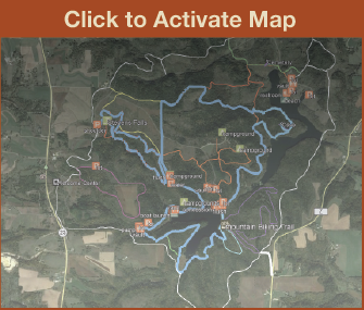
Directions and Trail Map

Click Map Image to load the full interactive map.
If viewing on a mobile device, open the trail map above to load into Google Maps App by touching the expand rectangle in the upper right corner.
Address for your GPS: 4175 State Highway 23, Dodgeville, WI 53533
| coordinates: 43.018276, -90.139682 |
| From Milwaukee | 2 Hours |
| From Madison | 1 Hour |
| From Green Bay | 3 Hours |
| From Wausau | 3 Hours |
| From Minneapolis | 4.5 Hours |
| From Chicago | 3 Hours |
Photos

|
| Stevens Falls at Governor Dodge State Park |

|
| Stevens Falls Trail at Governor Dodge State Park |

|
| Spring House on the Stevens Falls Trail |

|
| Spring House on the Stevens Falls Trail |

|
| Lost Canyon Trail at Governor Dodge State Park |

|
| Meadow Valley Trail at Governor Dodge State Park |

|
| Cox Hollow Lake Dam and Lakeview Trail |

|
| Cox Hollow Falls below the Cox Hollow Lake Dam |

|
| Pine Cliff Trail at Governor Dodge State Park |

|
| Pine Cliff Trail at Governor Dodge State Park |

|
| Pine Cliff Trail at Governor Dodge State Park |

|
| Twin Valley Lake from the Old Orchard Trail |

|
| Cemetery on Old Orchard Pass Trail |

|
| Cave Entrance at Governor Dodge State Park |

|
| Stevens Falls at Governor Dodge State Park |