

Getting close to nature is one of the top reasons to visit Door County. The rocky Door peninsula juts out into Great Lake Michigan. Its natural scenery and vistas make for ideal hiking. The county is home to 5 large state parks - each with a network of hiking trails. The Door peninsula is also orbited by a number of islands waiting to be explored. This article spotlights some of the most popular hiking trails Door County.
{tocify} $title={Table of Contents}
$ads={1}
advertisement

(IAT) Sturgeon Bay Segment
COUNTYDOOR COUNTY
COMMUNITIES
STURGEON BAY, MAPLEWOOD
TOTAL MILES
13.8-MILE POINT-TO-POINT
DIFFICULTY
MODERATE
CAMPING
Potawatomi State Park
The Eastern Terminus of the Ice Age National Scenic Trail is the observation tower at Potawatomi State Park. From there an epic 1200 mile national trail begins its exploration of terminal glacial moraines in Wisconsin. The Sturgeon Bay Segment descends the Niagara Escarpment and cuts along the Sturgeon Bay shipping channel into the City of Sturgeon Bay then heads south along the Ahpanee State Trail.
ICE AGE TRAIL - STURGEON BAY SEGMENT - TRAIL MAP AND ARTICLE HERE
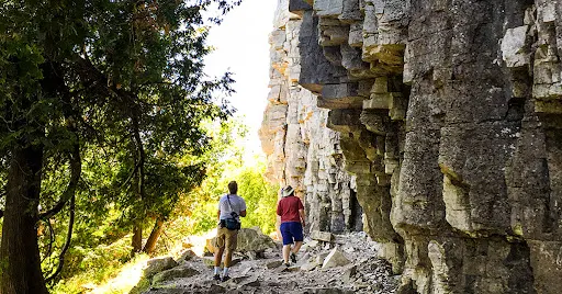
Eagle Trail at Peninsula State Park
COUNTYDOOR
COMMUNITIES
FISH CREEK
TOTAL MILES
2.5-MILE LOOP
DIFFICULTY
MODERATE
The Eagle Trail is among the most popular hiking trails in Wisconsin. It descends a bluff and follows along a narrow rocky and forested shoreline in the shadow of the imposing Niagara Escarpment. Its uneven surface is laced with roots and stones making it a challenging walk. You'll find caves, beautiful shoreline, and deep and dark cedar forests on the Eagle Trail.
EAGLE TRAIL ARTICLE AND TRAIL MAP HERE

Black Trail at Cave Point County Park
COUNTYDOOR
COMMUNITIES
JACKSONPORT, STURGEON BAY
TOTAL MILES
3-MILE LOLLIPOP
DIFFICULTY
EASY
Cave Point is fast becoming one of the most popular destinations in Door County. The scenic shoreline is pounded with Lake Michigan waves which have carved out sea caves.
Most visitors to Cave Point just stop in to see the photogenic shoreline. But, the park is also host to a rustic nature trail - the Black Loop. This trail begins at the neighboring Whitefish Dunes State Park. It makes a large loop in Cave Point County Park as it passes through birch and hardwood forest. You'll encounter deer and porcupine which are in abundance along this trail. You can take a connector trail down to water's edge to witness the sculpted shoreline.
CAVE POINT ARTICLE AND TRAIL MAP HERE

Red Trail at Whitfish Dunes State Park
COUNTYDOOR
COMMUNITIES
JACKSONPORT, STURGEON BAY
TOTAL MILES
2.8-MILE LOOP
DIFFICULTY
EASY
Though this trail is less storied than other Door County hiking trails, The Red Trail at Whitefish Dunes ranks high on my list of Wisconsin hiking experiences. The enormous dunes at Whitefish Bay are spectacle. On the Red Trail you experience these dunes by walking through them and over them. A single track cordwalk takes hikers into a pristine state natural area. The scenery along this trail is painted as if by watercolors.
RED TRAIL ARTICLE AND TRAIL MAP HERE

Thordarson Loop at Rock Island State Park
COUNTYDOOR
COMMUNITIES
WASHINGTON, ROCK ISLAND
TOTAL MILES
5.75-MILE LOOP
DIFFICULTY
EASY
This is one of the most popular adventure hiking trails in the State. It's an island hike, and requires traveling on two ferries - one to Washington Island, and the second to Rock Island. When you arrive you'll find a rocky bluff and shoreline capped by cedars and dense stands of hardwoods. There are treasures to discover on the island:The iconic Viking Boat House, rustic backpacking campsites, pristine sand beaches, and Wisconsin's oldest lighthouse.
HIKING ROCK ISLAND STATE PARK TRAIL MAP AND ARTICLE HERE

Door Bluff Headlands
COUNTYDOOR
COMMUNITIES
ELLISON BAY, LIBERTY GROVE
TOTAL MILES
2.5-MILE LOOP
DIFFICULTY
MODERATE
One of the least well known or visited parks in Door County is at the tip of the door at Ellison Bay. Door Bluff Headlands County Park is perched on a high bluff overlooking the Deaths Door Passage and Green Bay. It's a densely tangled and magical forest. You'll feel like you've stepped into a fantasy novel on hikes at Door Bluff Headlands.
DOOR BLUFF HEADLANDS ARTICLE AND TRAIL MAP HERE

Ellison Bluff
COUNTYDOOR
COMMUNITIES
ELLISON BAY
TOTAL MILES
1.1-MILE LOOP
DIFFICULTY
EASY
The easy loop at Ellison Bluff travels through birch and cedar forests that are blanketed with rare wildflowers. A wide path of crushed stone makes for an easy walk on gentle terrain. But, the highlight of this trail is the observation deck that extends off Ellison Bluff for up close views of the Niagara escarpment.
ELLISON BLUFF ARTICLE AND TRAIL MAP HERE

Toft Point
COUNTYDOOR
COMMUNITIES
BAILEY'S HARBOR
TOTAL MILES
2.5-MILE LOOP
DIFFICULTY
MODERATE
An enormous state natural area preserves a forest that could easily be confused with a Canadian wilderness. This former quarry was generously entrusted to the state by the Toft family. Remnants of the Toft homestead and guest cabins remain to be explored.
This trail is short and very easy. Further exploration of Toft Point requires a compass, a map, and wilderness skills. Naturalists and bird watchers who venture into the Toft Point wilderness will be rewarded with abundant wildlife and plant life encounters.
TOFT POINT ARTICLE AND TRAIL MAP HERE

Trails at Newport State Park
COUNTYDOOR
COMMUNITIES
ELLISON BAY, NORTHPORT
TOTAL MILES
30+ MILES NETWORKED TRAILS
DIFFICULTY
EASY
Newport State Park is Wisconsin's first and only State Wilderness Park. This large continuous property is a welcome retreat for more serious hikers looking to pack on miles where backpackers can hike camp to camp within the park. I recommend the Europe Bay Trail for day hikers. Newport State Park is also one of only a handful of official dark sky designated places in the world; so prepare for some star gazing at night.
NEWPORT STATE PARK ARTICLE AND TRAIL MAP HERE

Trails at Plum Island
COUNTYDOOR
COMMUNITIES
BAILEY'S HARBOR
TOTAL MILES
4.5-MILES NETWORKED TRAILS
DIFFICULTY
EASY
If you can navigate a boat or kayak through the perilous Deaths Door passage out to Plum Island you'll be rewarded with miles of fascinating hiking trails. Formerly a Coast Guard Station, Plum Island has been recently designated as a national wildlife refuge. It is now open for the public to explore. Designated hiking trails lead past historic buildings, lighthouses, to a wetlands area, and along beaches. You'll find Wisconsin's most rare flowering plants at Plum Island and have the opportunity to photograph Bald Eagles. If you are ever offered the opportunity to join an excursion out to Plum Island, take it.
PLUM ISLAND ARTICLE AND TRAIL MAP HERE

Trails at Ridges Preserve
COUNTYDOOR
COMMUNITIES
BAILEY'S HARBOR
TOTAL MILES
5-MILES NETWORKED TRAILS
DIFFICULTY
EASY
Wisconsin's first land trust preserved the curious land formations of parallel swales and ridges which support an abundance of wildlife and rare plants. The Ridges Sanctuary features several miles of networked trails that are easy for the whole family to enjoy. You'll also encounter a historic range light and remnants of early settlement in Door County.
RIDGES SANCTUARY ARTICLE AND TRAIL MAP HERE
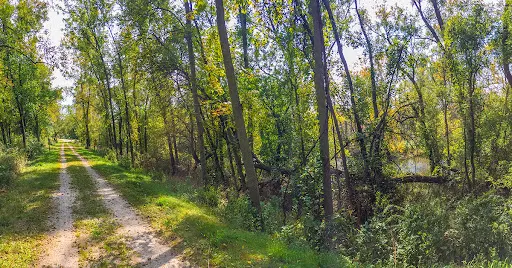
(IAT) Forestville Segment (Ahnapee State Bike Trail)
COUNTYDOOR COUNTY, KEWAUNEE COUNTY
COMMUNITIES
FORESTVILLE, ALGOMA, STURGEON BAY
TOTAL MILES
9.8-MILE POINT-TO-POINT
DIFFICULTY
EASY
CAMPING
Timber Trails Campground, Ahnapee River Trails Campground
The Forestville Segment of the Ice Age National Trail covers 9.8 miles between the Sturgeon Bay Segment and the Kewaunee Segment. The trail is very easy; paved with crushed stone and flat. The trail segment follows the Ahnapee State Trail - a Rails to Trails bicycle trail.
ICE AGE TRAIL FORESTVILLE SEGMENT ARTICLE AND TRAIL MAP HERE

Snowshoeing and Winter Hiking at Peninsula State Park
COUNTYDOOR COUNTY
COMMUNITIES
FISH CREEK
TOTAL MILES
5-MILES (LOOPS, VARIOUS TRAILS)
DIFFICULTY
EASY
Peninsula State Park in Door County offers three winter hiking or snowshoeing trails. These are modified winter versions of summer trails. The 1-mile long Minnehaha Trail skirts the lakeshore between Nicolet Beach and the trailhead for the Eagle Trail. A winter variation of the Sentinel Trail is the most popular winter hike. This 2-mile loop launches from the site of the old Eagle Tower and courses through dense pine and hardwood forest. Another 1.5-mile woodland loop trail begins at the Nature Center. Rentals for snowshoes are available at a bike and ski shop just outside the park.
PENINSULA STATE PARK WINTER HIKING TRAIL MAP AND ARTICLE HERE
Directions and Trail Map

Click Map Image to load the full interactive map.
Or Click here to open Interactive Map in Google Maps App.