|
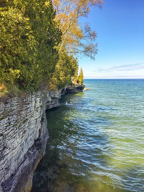
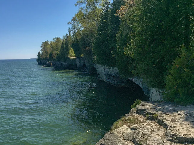
Cave Point is fast becoming one of Door County's most popular natural sights. Lake Michigan waves pound the rocky coastline here and have created wondrous sea caves. There are a few short trails along the bluffs at Cave Point, but an additional loop trail, the Black Trail, explores the hardwood forest set back from the shore and connects to the Whitefish Dunes State Park trail system.
The Black Trail is an adventure in its own right - and among the best nature walks in Door County. It is a 3-mile lollipop covering mild terrain. It begins and ends at the Whitefish Dunes State Park Parking Lot.
{tocify} $title={Table of Contents}
$ads={1}
advertisement
Cave Point is a spectacle of nature. Standing above the sea caves on a dolomite cliff you can feel the pounding of Lake Michigan's waves - a deep bone rattling churning below.
Beginning at the parking lots at Whitefish Dune State Park, the Black Trail makes its way along a quieter section of coastline towards Cave Point County Park. Along this first leg short spur trails offer glimpses of Lake Michigan at overlooks and picnic areas. One picnic area features artifacts from shipwrecks that have washed ashore over the years.
Both the Black Trails and the Brachipod Trail veer off to the northwest. The two trails cross Schauer Road together. Shortly after the road crossing the trails split - with the Black Trail continuing into Cave Point County Park. A few minutes walk beyond that intersection an unmarked spur trail leads to the main parking area at Cave Point. Take that spur trail to the shoreline to experience the spectacular sights at the Cave Point shoreline. If there is a good wind then the waves will be leaping into the air as they collide with sea caves at cave point.
Find your way back to the Black Trail for a more peaceful loop walk through the woods. The forest floor is covered in wildflowers and low shrubs. I nearly stepped on a porcupine as it slowly raised its quills to warn me. And, a few moments later two bucks jumped out of my way. The Black Trail cuts a loop through a less traveled area of the park which is abundant with wildlife.
The Black Trail circles back around leading back into Whitefish Dunes. If you want to continue adding miles to your walk I recommend taking the Red Trail to Old Baldy and back around through Whitefish Dunes State Natural Area. The Red Trail and Black Trail combined set up a nice 8 mile double loop hike with varying and spectacular scenery.

|
| Cave Point County Park in Door County WI |
Black Trail - At Whitefish Dunes State Park and Cave Point County Park
COUNTY: Door
COMMUNITIES: Jacksonport, Sturgeon Bay, Whitefish Bay
TOTAL MILES: 3 Mile lollipop
DIFFICULTY: Easy
CAMPING: Whitefish Dunes State Park
Directions and Trail Map
Click Map Image to load the full interactive map.
Address for your GPS: 3275 Clarks Lake Rd, Sturgeon Bay, WI 54235
| coordinates: 44.928090, -87.182246 |
| From Milwaukee | 2.5 Hours |
| From Madison | 3.5 Hours |
| From Green Bay | 1 Hours |
| From Wausau | 2.5 Hours |
| From Minneapolis | 5 Hours |
| From Chicago | 4.25 Hours |
Photos

|
| Cave Point County Park in Door County WI |

|
| Black Trail at Whitefish Dune State Park |

|
| Shipwreck artifacts along the Black Trail at Whitefish Dunes State Park |

|
| Cave Point County Park in Door County WI |

|
| Black Trail at Whitefish Dune State Park |

|
| Cave Point County Park in Door County WI |

|
| Cave Point County Park in Door County WI |

|
| Cave Point County Park in Door County WI |

|
| Cave Point County Park in Door County WI |
Links
Whitefish Dunes State ParkOfficial Trail Map
Door County Visitor Bureau
Door County Kayak Tours


