|
Exposed rock faces create a dramatic gorge along the sleepy Baraboo River in Rock Springs. Ableman's Gorge is a natural cut into the Baraboo Range, an ancient quartzite formation, which pinches the Baraboo River, a railroad, and Highway 136 into a tight S curve.
A state natural area at the site of a former quarry and scientific research site preserves virgin forest along the steep Baraboo riverbanks and the rock formations in the former quarry. The site is also a designated national historic landmark honoring the seminal geological studies of Charles Van Hise. A popular artesian well is also located on the property.
{tocify} $title={Table of Contents}
$ads={1}
advertisement

|
| Baraboo River at Ableman's Gorge |
An established 1 mile double loop hiking trail brings visitors to Ableman's Gorge into a former quarry and up close to the ancient quartzite rock faces. The trail is very easy and popular with families. An additional 1/2 mile of hiking is available on top of the ridge along unmarked rustic and difficult trails.
Most people who visit Ableman's gorge will simply stop to fill a bottle of pure mineral water from Rock Springs' namesake artesian well. There are two oblong pull-offs on the shoulder of highway 136 across from the Rock Springs Water Company. The well is centered in-between them. These pull-offs are not parking areas - but turn arounds for the tanker trucks to back into the Rock Springs Corp; so, don't plan to leave your car longer than it takes to fill up a 5-gallon jug of precious mineral water.
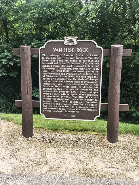
Further down the road there is another pull off with a Wisconsin historical marker. This is the site of Van Hise Rock. Charles Van Hise was a professor at the University of Wisconsin and sketched the rock while researching the development of mountains. The sketch was published in many academic journals and was used to prove new theories of metamorphic geology in the 1880's. Today, UW students still visit Van Hise Rock to see evidence of precambrian metamorphosis. This site was also designated as a national historic landmark in 1997.
Van Hise Rock is a good place to park a car and take a walk on the 1-mile double loop. The trail begins without a marker across the highway from the Van Hise pull-off. You'll immediately be immersed in thick forest and get up close to the exposed rock faces of the gorge. Along the trail you will come across the remains of a dynamite storage shelter built into the cliff side. Further along the trail the quarry floor opens up. There you will find the remains of a blast shelter.
For the more adventurous, unmarked rustic trails navigate the top of the stone bluffs. To reach them, park at the gravel lot alongside the Baraboo River that is just around the bend from Van Hise Rock. A precarious and difficult vertical trail rapidly climbs the bluff from the parking lot. Various off shoot trails connect to this line. The main line is apparent and follows the crest of the rock bluff. There are several points with long views of Ableman's Gorge and Rock Springs.

|
| Ableman's Gorge |
Ableman's Gorge State Natural Area Trail
COUNTY: Sauk
COMMUNITIES: Rock Springs
TOTAL MILES: .8 mile double loop
DIFFICULTY: Easy
Directions and Trail Map
Click Map Image to load the full interactive map.
Or Click here to open Interactive Map in Google Maps App.
Address for your GPS: 598 N River St, Rock Springs, Village of, WI 53961
| coordinates: 43.488576, -89.915843 |
| From Milwaukee | 2 Hours |
| From Madison | 1 Hour |
| From Green Bay | 3 Hours |
| From Wausau | 2 Hours |
| From Minneapolis | 3.5 Hours |
| From Chicago | 3 Hours |
Photos

|
| Ableman's Gorge |

|
| Dynamite Storage at Ableman's Gorge |

|
| Historic sign at Ableman's Gorge |

|
| Van Hise Rock at Ableman's Gorge |

|
| Rock Springs Artesian Well at Ableman's Gorge State Natural Area |

|
| Ableman's Gorge Entrance |

|
| Ableman's Gorge |

|
| Ableman's Gorge |

|
| Ableman's Gorge |

|
| Ableman's Gorge |

|
| Ableman's Gorge |

|
| Ableman's Gorge |

|
| Ableman's Gorge |

|
| Ableman's Gorge |

|
| Ableman's Gorge |

|
| Ableman's Gorge |

