

Hikers can find dozens of backpacking routes ranging from single overnights to weeklong expeditions in Wisconsin's tranquil landscape of deep woods, rolling hills, and hidden valleys. This State bounded by a pair of Great Lakes and the Mississippi River is home to two national scenic trails and sprawling national, state, and country forests - each hosting unique backpacking experiences. These landscapes inspired John Muir, Aldo Leopold, Jens Jenson, and the nation's leading conservationists. To this day, these lands remain open to you - to walk, explore, hunt, fish, and camp in. To be inspired within, or just for relaxation - Wisconsin's public lands are vast and free.
Below is a directory and summary of Wisconsin backpacking routes and potential trip plans. Try weekend loop trails, hut-hopping between shelters and cabins, weekend point-to-points, and weeklong section hikes.
Only you can know your tolerance for mileage and camping preferences, so take these trip ideas and make them yours. Beyond the samples of trip itineraries featured on this page, you can plan your own unique trips. Ice Age Trail or North Country Trail by using detailed descriptions, maps, and photographs available on this site as a guide.
{tocify} $title={Table of Contents}
$ads={1}
advertisement
WHERE TO GO BACKPACKING IN WISCONSIN
Weekend Loops and Out-N-Backs
Once you’ve got your backpacking kit, you can hit the trail whenever the mood strikes. Wilderness and dispersed campsites are often free, rarely full, and offer solitude most car campers can only dream of. The hikes below—short loops and out-and-backs perfect for a single night or a lazy long weekend—trade high mileage for high reward: peaceful forests and some of the most scenic, private campsites in Wisconsin.
Hidden Lakes Loop
DIFFICULTYBEGINNER
TOTAL MILES
15.5-MILE LOOP
REGION
UP-NORTH (NORTHERN WOODLANDS)
COUNTY
FOREST COUNTY
NEARBY COMMUNITIES
EAGLE RIVER
CAMPING TYPE
Mix of reservable drive-in sites and designated and non-designated disperesed primitive sites.
WHAT YOU'LL LOVE ABOUT THIS HIKE
Easy walking with beutiful camping beside small lakes.
SIGHTS ALONG THIS HIKE
Franklin Lake, Echo Lake, Pat Shay Lake, Dense Pine Forest, Mature Hardwood Forest, Wetlands, White Deer Lake, Luna Lake, Mickinley Lake, Three Johns Lake, Four Ducks Lake
WILDLIFE
Loons, Trumpeter Swans, Bald Eagles, Black Bear, Coyote, White Tailed Deer AMMENITIES
Paved access roads, paved parking lots, potable water, vault toilets, beaches, boat ramps
The Hidden Lakes Trail is an ideal introduction to backpacking, and it will be enjoyed by hikers of any level. A single-track trail circumnavigates Butternut Lake via a loop that meanders between many smaller secluded lakes. There are two major campgrounds separated by 5 miles along the trail route, Franklin Lake and Luna-White Deer Lake. Hikers can reserve drive-in campsites at either campground to use as a start and end point. In addition to these sites there are primitive campsites and primitive dispersed camping is allowed in the national forest.
Three-Day/Two-Night-Itinerary
DAY 1 (5-Miles):
Begin at the Franklin Lake Picnic Area and head west on the trail, hiking the loop counterclockwise. Hike through dense pine forest beside Franklin Lake and then on wide two-track trails through the Nicolet North XC Ski Area. Camp at a primitive site at Pat Shay Lake.
DAY 2 (6-miles):
Hike 6 miles towards Luna / Whitedeer Lake Campground. Keep going and camp beside Butternut Lake at the primitive site just before the bridge over the Pine River. If that site is full then move on to the primitive sites at Three Johns Lake and disperse camp if needed in the woods between Three Johns and Mckinley Lake.
DAY 3 (4-miles):
Hike 4 miles to return to Franklin Lake Picnic Area.
ARTICLE (WISCONSIN-EXPLORER)
Governor Dodge State Park Loop
DIFFICULTYBEGINNER
TOTAL MILES
17.5-MILE LOOP
REGION
SOUTHWEST (DRIFTLESS AREA)
COUNTY
IOWA COUNTY
NEARBY COMMUNITIES
DODGEVILLE
CAMPING TYPE
Mix of reserved drive-in sites and reserved walk-in backpacking sites
WHAT YOU'LL LOVE ABOUT THIS HIKE
Easy and long walks with a surprising variety of sights
SIGHTS ALONG THIS HIKE
Cox Hollow Lake, Stephens Falls, Lost Canyon, Twin Valley Lake, Old Cemetery, Thomas Cave, Pine Cliff State Natural Area
WILDLIFE
Songbirds gallore, squirrels and white tailed deer, racoons in your campsite at night, and the occasional fox
AMMENITIES
Paved access roads, paved parking lots, potable water, flush restrooms, showers, beaches, concessions, boat liveries, fire rings with grills, picnic tables in sites
Governor Dodge State Park in Southwest Wisconsin’s driftless area is an immensely popular park with two man-made lakes and a surprising diversity of scenery. There isn’t really a need to wear a backpack when hiking here as the walk-in campsites are less than a mile from a parking lot where there are flush toilets and showers. But if you want to try out backpacking without committing to the risks of a wilderness trip then you can park your vehicle further away from the sites and make a physically challenging overnight backpacking loop.
Two-Day/One-Night-Itinerary
BEFORE ARRIVAL:
Reserve a backpacking campsite.
DAY 1 (10-Miles): Park at Enee Point and head east along park roads towards Cox Hollow. Turn off and head north to the Cox Hollow Campground. Complete the Lost Canyon Loop by returning on the Meadow Valley Trail and continuing on Meadow Valley to the Woodland Trail. Next, take the Outer Horse Trail to Hickory Ridge and arrive at your campsite.
DAY 2 (9.5-miles):
Continue clockwise on the Outer Horse Loop and cut over to the Old Orchard and Woodland Trail. Take a loop on the Cave Trail to see Thomas Cave before returning to Cox Hollow Beach. Cross the dam to reach the Lakeview and Pine Cliff Trails. The Pine Cliff Trail leads back to Enee Point.
ARTICLE (WISCONSIN-EXPLORER)
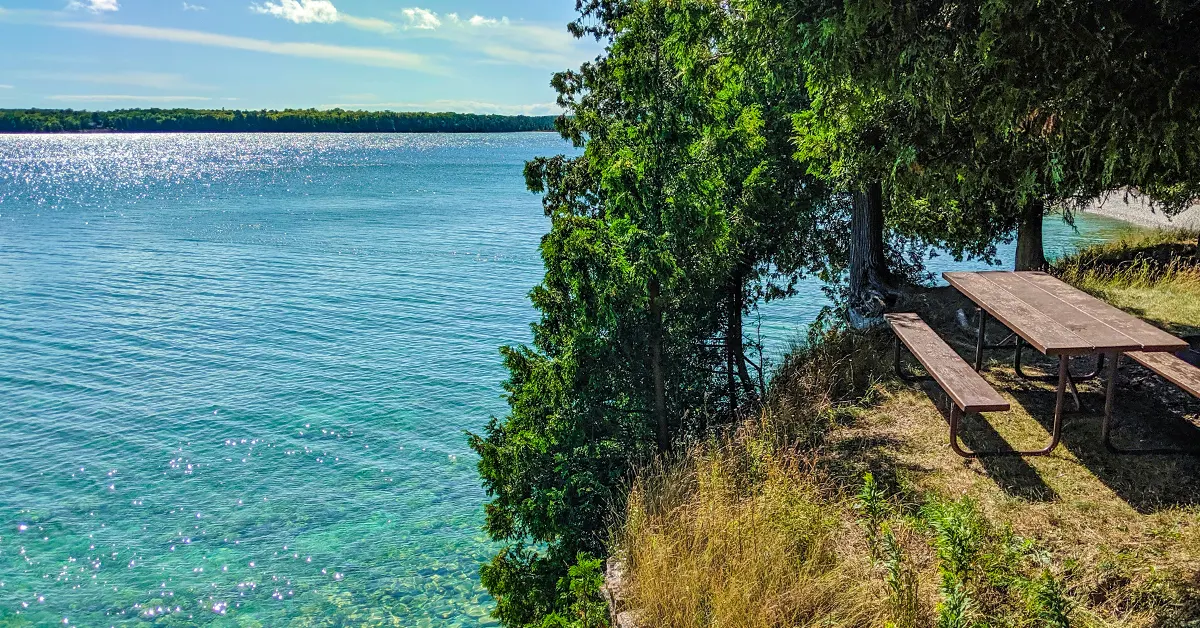
Rock Island State Park – Thordarson Loop
DIFFICULTYBEGINNER
TOTAL MILES
5.7-MILE LOOP
REGION
EASTERN
COUNTY
DOOR COUNTY
NEARBY COMMUNITIES
JACKSON HARBOR
CAMPING TYPE
Reservable remote walk-in sites.
WHAT YOU'LL LOVE ABOUT THIS HIKE
An adventure on a magical island.
SIGHTS ALONG THIS HIKE
Rock Island State Park, Pottawatomie Lighthouse, fake petroglyphs, Viking Boathouse, historic water tower, follies, old cemeteries, Gate to the West, beach, birch, oak, and maple hardwood forest
WILDLIFE
Songbirds gallore, squirrels and white tailed deer, racoons in your campsite at night
AMMENITIES
Passenger ferry, potable water, vault toilets, beach, cart rental, fire rings with grills, picnic tables in sites
Rock Island is an enchanted place accessed by taking a car ferry off the tip of Door County to Washington Island and then a passenger ferry from Washington Island to Rock Island. There are no vehicles on this island and the night sky is dark and glimmering with stars. I recommend spending at least two nights on the island to soak in the island camping experience.
3 DAY/2-NIGHT ITINERARY
BEFORE ARRIVAL:
Reserve a backpacking campsite (A,B,C,D,E) for night 1, and a traditional walk-in site (1-35) for your 2nd night.
DAY 1 (2-miles):
After arriving at the Island dock, take the Thordarson Loop counterclockwise to reach your first campsite.
DAY 2 (3.5-miles):
The next day continue counterclockwise around the island to return to the family campground.
DAY 3 (1/2-Mile):
Return to the dock and leave the island.
ARTICLE (WISCONSIN-EXPLORER)

Newport State Park Triple Loop
DIFFICULTYBEGINNER
TOTAL MILES
12-MILE TRIPLE LOOP
REGION
EASTERN
COUNTY
DOOR COUNTY
NEARBY COMMUNITIES
ELLISON BAY
CAMPING TYPE
Reservable walk-in remote sites.
WHAT YOU'LL LOVE ABOUT THIS HIKE
Boreal forest on the shore of Lake Michigan.
SIGHTS ALONG THIS HIKE
Lake Michigan, Europe Lake, Rowleys Bay, Newport Conifer-Hardwoods State Natural Area
WILDLIFE
Songbirds, squirrels, and white tailed deer
AMMENITIES
Paved access roads, paved parking lots, potable water, vault toilets, beach, fire rings with grills, picnic tables in sites
Newport is a state wilderness park which is a bit of a twist on the idea of a state park. The park holds a significant portion of Lake Michigan shoreline in Door County. It is largely undeveloped, with a short drive into two larger paved parking areas. There are 16 reservable walk-in sites and each has a fire ring, picnic table, and either a latrine or nearby to a vault toilet building.
3 DAY/2-NIGHT ITINERARY
BEFORE ARRIVAL:
Reserve sites in advance with night-1 at one of the Europe Bay/Europe Lake sites and night-2 at the Rowley’s Bay sites.
DAY 1 (3-Miles):
Park at the beach lot and hike north on the Europe Bay Trail to reach your first campsite.
DAY 2 (6-miles):
Hike south on the Europe Bay Loop and continue to follow the shore on the Newport Trail, Sand Cove Trail, and Duck Bay Cove Trail and over the Rowleys Bay Trail to your second campsite.
DAY 3 (2.5-Mile):
Return to parking via the Ridge Trail
ARTICLE (WISCONSIN-EXPLORER)

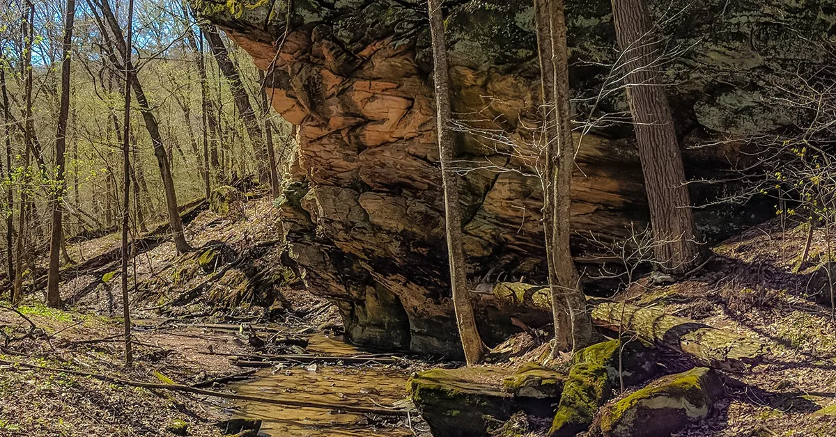
Kickapoo Valley Reserve (KVR) Hanson Rock Loop
DIFFICULTYBEGINNER
TOTAL MILES
7-MILE LOOP
REGION
SOUTHWESTERN (DRIFTLESS AREA)
COUNTY
VERNON COUNTY
NEARBY COMMUNITIES
LA FARRGE
CAMPING TYPE
Reservable remote walk-in sites
WHAT YOU'LL LOVE ABOUT THIS HIKE
Bucolic countryside and challenging drifless area hills.
SIGHTS ALONG THIS HIKE
Kickapoo River, Hanson Rock
WILDLIFE
Songbirds, squirrels, and white tailed deer
AMMENITIES
Paved access roads, off-street parking lots, stone and earth fire rings in campsites, central staffed visitor center with potable water and flush toilets.
The Kickapoo Valley Reserve (KVR) is a massive land reserve in the driftless area along the scenic Kickapoo River between Ontario and La Farge. Hikers can connect a web of equestrian, mountain bike, and hiking trails to form long multi-day hikes. KVR has several trailside rustic campsites that can be reserved at the Visitor Center. The area includes steep hill climbs and river and stream fords which hikers must negotiate. I’ll provide a beginner-loop itinerary, but as always, feel free to use the KVR map to create your own multi-day plan.
2 DAY/1-NIGHT ITINERARY
BEFORE ARRIVAL:
Reserve campsite “F” at the KVR Visitor Center.
DAY 1 (4.5-Miles):
Park at Campsite P on Weister Creek Road and hike the West Ridge Trail to the Hanson Rock Trail. Climb several hundred feet to Hanson Rock overlook and descend the south face to reach Campsite F. This campsite is shaded by trees and set against a stream and has a spring box for drinking water. Beware that the valley can flood fast in heavy rainstorms.
DAY 2 (3-miles):
Hike counterclockwise on the West Ridge Trail to the Ice Cave Trail and then proceed up the Little Canada Trail to regain the West Ridge Trail and return to parking at Campsite P.
ARTICLE (WISCONSIN-EXPLORER)

The Lauterman Loop
DIFFICULTYINTERMEDIATE
TOTAL MILES
14-MILE TRIPLE LOOP
REGION
UP NORTH (NORTHERN WOODLANDS)
COUNTY
FLORENCE COUNTY
NEARBY COMMUNITIES
FLORENCE
CAMPING TYPE
First-come-first-serve remote sites
WHAT YOU'LL LOVE ABOUT THIS HIKE
You'll have the whole place to yourself.
SIGHTS ALONG THIS HIKE
Artesian Well, Pine National Wild and Scenic River, Lake Lauterman, Perch Lake
WILDLIFE
Loons, Bald Eagles, Black Bear, Wolves
AMMENITIES
Gravel access roads, off-street parking lots, artesian well, vault toilets, thunder boxes, fire rings, picnic tables in sites
The Lauterman National Recreation Area combines three lakes, two campgrounds, and over a dozen miles of interconnected multi-use trails in the Chequamegon-Nicolet National Forest. The Lost Lake campground is the hub of activity with drive-in campsites, a beach, and a boat ramp. Across Lost Lake is an old youth camp where visitors can now rent individual cabins or the whole camp with a dining hall and staff cabins included. Hiking trails connect to the nearby Chipmunk Rapids campground set beside the Wisconsin Scenic Pine River. From the Pine River, a network of ski trails branch off to the north connecting to Lake Lauterman and Perch Lake where hikers can snag one of ten scenic remote campsites. If the hike from Lost Lake to Perch Lake isn’t enough, the Whisker Lake Federal Wilderness is directly across the street from Perch Lake.
2 DAY/1-NIGHT ITINERARY
DAY 1 (7-Miles):
Park at Lost Lake and follow the Ridge Trail around counterclockwise for views of the Pine River, then connect to Chipmunk Rapids Campground. Fill up with water at the Artesian Well at Chipmunk Rapids. Then cross the Lost Lake Road bridge to the Lauterman Trailhead. Follow the Chipmunk Trail for 3-miles over hilly terrain to a warming shelter set high on a hill overlooking Lake Lauterman. Follow the Lauterman Trail around to the north end of the lake and connect with the Perch Lake Loop which will take you across Highway 70. Choose a primitive campsite on the shore of Perch Lake.
DAY 2 (7-miles):
Return to Lost Lake using the same trails from your first day’s hike.
ARTICLE (WISCONSIN-EXPLORER)

Apostle Islands Lakeshore Trail Out-And-Back
DIFFICULTYINTERMEDIATE
TOTAL MILES
10-MILE OUT-AND-BACK
REGION
UP NORTH (LAKE SUPERIOR)
COUNTY
BAYFIELD COUNTY
NEARBY COMMUNITIES
CORNUCOPIA
CAMPING TYPE
THREE RESERVABLE REMOTE BACKPACK SITES
WHAT YOU'LL LOVE ABOUT THIS HIKE
Boreal forest on high cliffs overlooking the Apostle Island sea caves.
SIGHTS ALONG THIS HIKE
Meyers Beach, Apostle Islands National Lakeshore, Lake Superior, Boreal Forest, Sea Caves, Lunch Beach
WILDLIFE
Songbirds, Black Bears, White Tailed Deer
AMMENITIES
Gravel access roads, off-street parking lots, thunder boxes, fire rings with grills, secure bear bins, tent pad, picnic tables in sites
The Apostle Islands National Lakeshore is the closest thing we have to a national park in Wisconsin. It’s managed by the National Park Service even if it doesn’t get the national park designation. Most of the park is on islands that are accessible if you have a boat that is fit for Lake Superior. The park service included one hiking trail on the mainland that you can drive to without a ferry service. From Meyer’s Beach, a five-mile trail unfolds along the top of an imposing Lake Superior bluff. The trail is easygoing and popular as it leads to some distant and obscured views of the famed Apostle Island sea caves. This Lakeshore trail terminates at a beach and primitive campsite.
2 DAY/1-NIGHT ITINERARY
BEFORE ARRIVAL:
Reserve the Mainland Campsite 30 days in advance of your trip.
DAY 1 (5-Miles):
Park at Meyers Beach and hike along the edge of Lake Superior and stop to view some of the sea caves. Continue on to Lunch Beach and camp at the Lakeshore Trail Campsite.
DAY 2 (5-miles):
Return to Meyers Beach using the same trails from your first day’s hike.
ARTICLE (WISCONSIN-EXPLORER)

Pattison State Park Loop
DIFFICULTYBEGINNER
TOTAL MILES
7.6-MILE LOOP
REGION
UP NORTH (NORTHERN WOODLANDS)
COUNTY
DOUGLAS COUNTY
NEARBY COMMUNITIES
SUPERIOR
CAMPING TYPE
Remote backpack sites must be reserved
WHAT YOU'LL LOVE ABOUT THIS HIKE
Boreal forest and awesome waterfalls
SIGHTS ALONG THIS HIKE
Big Manitou Falls, Little Manitou Falls, Interffalls Lake, Nemadji River
WILDLIFE
Songbirds, Bald Eagles, Black Bears, White Tailed Deer
AMMENITIES
Staffed rangers office, Paved off-street parking lots, paved access roads, potable water, flush toilets, showers, beach, concessions, fire rings in sites, picnic tables in sites, tent pads
Pattison State Park is famous for two waterfalls on the Black River, Big Manitou Falls and Little Manitou Falls. Big Manitou is the highest waterfall in the state. The North Country National Trail flows through the park, but unfortunately, it is a disconnected segment. There are three reservable backpacking sites and a trail shelter. These sites happen to be across the river from the NCT. Nevertheless, an exciting beginner backpacking loop can be made in the park.
2 DAY/1-NIGHT ITINERARY
BEFORE ARRIVAL:
Reserve a backpacking site in advance.
DAY 1 (3.6-Miles):
Park across from Big Manitou Falls in the lot off County Highway B. See Big Manitou Falls then cross Highway 35 and hike the Beaver Trail on the west side of Interfalls Lake. Travel south to the end of the trail to see Little Manitou Falls. Then backtrack to the CCC Bridge and cross it. There is a connector trail between the Beaver Loop and the Overlook Trail. Take that connector and follow the Overlook Trail to the Oak Ridge Trail and arrive at your campsite.
DAY 2 (4-miles):
Hike counterclockwise on the Oak Ridge Trail and connect to the River View Trail. Then take the Overlook Trail back to the Beaver Trail to the beach area. Cross under the tunnel and return to your vehicle in the parking area.
ARTICLE (WISCONSIN-EXPLORER)

Chippewa Moraine Circle Trail Loop
DIFFICULTYBEGINNER
TOTAL MILES
5-MILE LOOP
REGION
UP NORTH (NORTHERN WOODLANDS)
COUNTY
CHIPPEWA COUNTY
NEARBY COMMUNITIES
CORNELL
CAMPING TYPE
Remote sites - permit required at visitor center
WHAT YOU'LL LOVE ABOUT THIS HIKE
Easy trail past tons of small lakes and ponds
SIGHTS ALONG THIS HIKE
North Shattuck Lake, South Shattuck Lake, Chippewa Moraine
WILDLIFE
Songbirds, White Tailed Deer, the occasional black bear, coyote
AMMENITIES
Staffed rangers office, Paved off-street parking lots, paved access roads, potable water, vault toilets, fire rings in sites, picnic tables in sites
The Chippewa Moraine is an Ice Age Trail Scientific Area where the terrain is sculpted with moraines and pockmarked with kettle lakes. The Circle Trail is a loop bifurcating off the Ice Age Trail. There’s a nice visitors center on the top of a grand hill overlooking the area. There are two reservable primitive campsites on the trail, one on North Shattuck Lake and another on the shores of an unnamed lake. Yep, there are so many lakes here they couldn’t even name them all. For those just getting into backpacking, the short length of this loop trail may be the right place to start and get used to primitive camping along the trail.
2 DAY/1-NIGHT ITINERARY
BEFORE ARRIVAL: Reserve a backpacking site in advance.
DAY 1 (4.5-Miles):
Park at the David Obey Interpretive Center and get a permit for the campsite on North Shattuck Lake. Fill up with water and head out from the interpretive center onto the Ice Age Trail in a clockwise route around the loop. There are a few trail intersections in this first mile before reaching the campsite on the unnamed lake, so stay alert. Cross County Highway M and continue south on the IAT until you reach the Circle Trail intersection, then follow the Circle Trail around to the west and eventually to a second highway crossing. Stay on track until you reach another intersection with the IAT and then turn right to loop around North Shattuck Lake. A short spur trail leads to the Hiker’s Campsite.
DAY 2 (1/2-mile):
Finish the last half mile to reach the interpretive center.
ARTICLE (WISCONSIN-EXPLORER)

Chippewa Lobe Trail Loop
DIFFICULTYINTERMEDIATE
TOTAL MILES
12-MILE LOOP
REGION
UP NORTH (NORTHERN WOODLANDS)
COUNTY
TAYLOR COUNTY
NEARBY COMMUNITIES
RIB-LAKE, MEDFORD
CAMPING TYPE
DISPERSED CAMPING ANYWHERE ALONG THE TRAIL AND A PRIMITIVE FIRST-COME-FIRST-SERVE CAMPSITE
WHAT YOU'LL LOVE ABOUT THIS HIKE
The primitive campsite is worth the challenging terrain
SIGHTS ALONG THIS HIKE
Chequamegon National Forest
WILDLIFE
Songbirds, Whie Tailed Deer, black bear, wolves, loons
AMMENITIES
Gravel off-street parking lot, gravel access roads, Mondeaux Lodge nearby offers 24-hour access coin op shower, Artesian well located nearby - not on trail,
The Chippewa Lobe Loop (not to be confused with the Chippewa Circle Trail above) is one of the only backpackable loops along the Ice Age National Trail. The soil is poorly drained and the trail here is often mucky. Finding ways around mud pits and over streams adds an athletic challenge to this hike. There is a well-regarded primitive campsite beside a pond and wetland about halfway around the loop. Good wilderness navigation skills are required - parts of the trail don't look like a trail, it's easy to miss signs and blazes, and you'll be crossing many other trail intersections. Use the Map-My-Run app to track your route if you need to backtrack.
2 DAY/1-NIGHT ITINERARY
DAY 1 (5-Miles):
Park at the Ice Age Trail parking lot on County Highway E and head westbound on the Ice Age Trail Jerry Lake Segment. After 1.5 miles be on the lookout for a Chippewa Lobe Side trail. Follow the blue blazes clockwise around the loop. Camp at the site by the pond about halfway around the loop.
DAY 2 (7-mile):
Continue the loop and return on the Ice Age Trail Jerry Lake Segment heading eastbound.
Hikes to Shelters and Cabins
Wisconsin's weather can get scary and dangerous with summer thunderstorms that are awesome to behold. Timber shelters provide a more secure place to wait out a storm and extra room to spread out in. They also allow hikers to lighten their load - potentially forgoing a tent altogether.
There are large Adirondack shelters (which must be reserved prior to your hike) featured along the Southern and Northern Kettle Moraine State Forest segments of the Ice Age Trail. A few other first-come-first-serve free shelters can be found along trails around the state. And here and there, you'll find some unique cabins built just for hikers.

Ice Age National Trail: Whitewater Segment to Blue Spring Lake Segment
DIFFICULTYBEGINNER
TOTAL MILES
19-MILES POINT-TO-POINT
REGION
SOUTHEAST
COUNTY
WAUKESHA COUNTY
NEARBY COMMUNITIES
EAGLE
CAMPING TYPE
Drive-in campground, Trail shelters that must be reserved
WHAT YOU'LL LOVE ABOUT THIS HIKE
Trails close to Chicago, Milwaukee, and Madison.
SIGHTS ALONG THIS HIKE
Kettle Moraine State Forest
WILDLIFE
Songbirds, White Tailed Deer
AMMENITIES
Gravel off-street parking lots, paved access roads, reservable shelters, campground
The Southern Kettle Moraine State Forest hosts many continuous miles of the Ice Age Trail and provides large Adirondack shelters along the trail to enable backpackers. The Kettle Moraine Trails are the most popular backpacking routes in Wisconsin as a result. The scenery does not provide a sense of being in the wilderness, but the forest is dense and hilly, so the routes make for a good workout and escape into the woods. Bonus, these southern areas are nearby to major metropolitan areas, so they are easily accessible to more people. That does make it difficult to snag a shelter reservation. I recommend reserving a shelter eleven to eight months in advance for popular summer weekends.
The Whitewater Segment is the southernmost segment of the Kettle Moraine section. It connects directly to the Blackhawk Segment where there is a trail shelter. This first itinerary will cover Whitewater Lake to Emma Carlin Trailhead which will be the entire distance of the Whitewater, Blackhawk, and Blue Spring Lake Segments.
2 DAY/1-NIGHT ITINERARY
BEFORE ARRIVAL:
Reserve a Southern Kettle Moraine State Forest Shelter #3
DAY 1 (11.5-Miles):
Park a car at the Emma Carlin Trailhead lot and shuttle drive down to Clover Valley Road. There is shoulder parking for a couple vehicles on Clover Valley Road. If you need to you can park at the Rice Lake Nature Trail which is a half-mile away. Follow the trail northeast to Highway 12 to complete the Whitewater Segment. Keep going on the Blackhawk Segment to reach the Shelter.
DAY 2 (7.5-miles):
Continue hiking the Blackhawk Segment and the Blue Spring Lake Segment to reach the Emma Carlin Trailhead.
Whitewater Segment Trail Article
Blackhawk Segment Trail Article
Blue Spring Lake Segment Trail Article

Ice Age National Trail: Blue Spring Lake to Scuppernong
DIFFICULTYBEGINNER
TOTAL MILES
15-MILES POINT-TO-POINT
REGION
SOUTHEAST
COUNTY
WAUKESHA COUNTY
NEARBY COMMUNITIES
EAGLE
CAMPING TYPE
SHELTER MUST BE RESERVED
WHAT YOU'LL LOVE ABOUT THIS HIKE
Trails close to Chicago, Milwaukee, and Madison.
SIGHTS ALONG THIS HIKE
Kettle Moraine State Forest
WILDLIFE
Songbirds, White Tailed Deer
AMMENITIES
Gravel off-street parking lots, paved access roads, reservable shelters, privy near shelters, potable water, ranger station with interpretive visitor center and flush toilets, picnic shelters, campgrounds
The next segments of the IAT in the Southern Kettle Moraine are the Stoney Ridge Segment, Eagle Segment, and the Scuppernong Segment. There are a few more camping opportunities on these segments, with two great shelters, Pinewoods Campground, and the nearby Ottawa Lake Campground.
2 DAY/1-NIGHT ITINERARY
BEFORE ARRIVAL:
Reserve a Southern Kettle Moraine State Forest Shelter #1
DAY 1 (9.5-Miles):
Park a car at the Pinewoods campground and shuttle drive back to the Emma Carlin Trailhead. Hike 1.25 miles to reach the Kettle Moraine Forest Headquarters and stop and see the museum. Fill up with water and continue on the Stony Ridge Segment to Highway 59. Across the highway begin the Eagle Segment. Fill up with water at the Highway 67 Trailhead and then cross 67 and climb the spur trail to Shelter #1.
DAY 2 (5-mile):
Complete the Scuppernong Segment to reach Pinewoods Campground.
Stony Ridge Segment Trail Article
Eagle Segment Trail Article
Scuppernong Segment Trail Article

Ice Age National Trail: Milwaukee River Segment to Greenbush Segment
DIFFICULTYBEGINNER
TOTAL MILES
31-MILES POINT-TO-POINT
REGION
SOUTHEAST
COUNTY
FOND DU LAC COUNTY
NEARBY COMMUNITIES
DUNDEE, PARNELL,KEWASKUM
CAMPING TYPE
Group drive-in campground, trail shelters that must be reserved
WHAT YOU'LL LOVE ABOUT THIS HIKE
Deep kettles and high eskers
SIGHTS ALONG THIS HIKE
Parnell Tower, Kettle Moraine State Forest
WILDLIFE
Songbirds, White Tailed Deer
AMMENITIES
Paved off-street parking lots, paved access roads, reservable trail shelters, privy near shelters, potable water, picnic shelters, campgrounds
The Northern Kettle Moraine State Forest draws campers, bikers, mountain bikers, anglers, and hikers to its parks and sites. Its two major campgrounds, Mauthe Lake and Long Lake are connected by a newly installed crushed stone bike trail. The Ice Age Trail cuts a meandering path from south to north on three segments, the Milwaukee River segment, Parnell Segment, and Greenbush Segment. With major family campgrounds and five large Adirondack shelters, long distance hikers can make their way through this forest in one long weekend. Remember to reserve your sites and shelters many months in advance of your trip.
4-DAY/3-NIGHT ITINERARY
BEFORE ARRIVAL:
Reserve shelter #2 for night 1, shelter #3 for night 2, and shelter #5 for night 3 in advance.
DAY 1 (8-Miles):
Park a vehicle at the Greenbush Segment Trailhead on Sheboygan County Highway P in Glenbeulah and shuttle down to the parking lot off Washington County Highway H. Proceed north towards New Fane. Stop at the New Fane Trails for lunch and to refill with tap water. Camp at Shelter #2 after hiking 8-miles.
DAY 2 (7-miles):
Hike 1.5-miles to Mauthe Lake and refill with water and go for a morning swim and grab a hot shower at the beach. Continue on past Crooked Lake to Shelter #3 having hiked 7-miles. There are some streams near Shelter 3 where you can grab water to filter.
DAY 3 (9-miles):
hike 5-miles to the Parnell Tower loop trail and take it to see Parnell Tower and refill with water. Hike three more miles to reach Shelter #5 for a total hike of 9-miles. Your legs will be very sore from climbing to and from Parnell Tower. Shelter #5 has a water pump nearby.
DAY 4 (7-miles):
hike 7-miles to the Glenbeulah parking area.
Milwaukee River Segment Trail Article
Parnell Segment Trail Article
Greenbush Segment Trail Article

Ice Age National Trail: Emmons Creek to Skunk and Foster Lake
DIFFICULTYBEGINNER
w TOTAL MILES
16-MILES POINT-TO-POINT
REGION
CENTRAL
COUNTY
PORTAGE COUNTY
NEARBY COMMUNITIES
WAUPACA, AMHERST
CAMPING TYPE
Reservable drive-in campsites, first-come-first-served log cabin
WHAT YOU'LL LOVE ABOUT THIS HIKE
Easy hiking on sandy footpaths
SIGHTS ALONG THIS HIKE
Waupaca River,
WILDLIFE
Songbirds, White Tailed Deer
AMMENITIES
Paved off-street parking lots, paved access roads, flush restrooms, potable water, picnic shelters, campgrounds
Here’s a super fun one that most hikers don’t think about. Fun, and pleasant, and easy. A 3-day trip will cover Emmons Creek Segment, Hartman Creek Segment, Waupaca River Segment, and Skunk and Foster Lake Segment. A long portion of the trail passes through Hartman Creek State Park where there is a family campground beside Allen Lake. There’s a lengthy road connection of 2.2-miles between the Hartman Creek Segment and the Waupaca River Segment, but this walk is along quiet roads with plenty of room to accommodate pedestrians. The Waupaca River Segment doesn’t offer many views of the Waupaca River, but it does offer a very unique camping experience at a little log cabin with room for 3-4 inside and plenty of space around it for tents. A much shorter 3/4 -mile road connection connects to the Skunk and Foster Lake Segment. There are spacious parking lots at both ends of this trail.
3-DAY/2-NIGHT ITINERARY
BEFORE ARRIVAL:
Reserve a campsite at Hartman Creek State Park for night-1 in advance
DAY 1 (5-Miles):
Park your vehicle at the Skunk and Foster Lake State Natural Area parking lot and shuttle down the Emmons Creek trailhead on 2nd Ave. Hike 5-miles to reach your site at Hartman Creek SP.
DAY 2 (6-miles):
Hike 6-miles along the Ice Age Trail and Nelson Drive and Cobbtown Road to reach the Waupaca River Segment and another 2-miles to reach the log cabin. The log cabin is between two large sand quarries, so don’t plan on sleeping in.
DAY 3 (4.5-miles):
Follow Foley Road north and cross Highway 10. Follow the Skunk and Foster Lake Segment to its end and return 1/8 of a mile south on N. Foley Drive to reach the parking area.
Emmons Creek Segment Trail Article
Hartman Creek Segment Trail Article
Waupaca River Segment Trail Article
Skunk and Foster Lake Segment Trail Article

Ice Age National Trail Underdown Segment
DIFFICULTYBEGINNER
TOTAL MILES
16-MILES OUT-AND-BACK
REGION
UP NORTH (NORTHERN WOODLANDS)
COUNTY
LINCOLN COUNTY
NEARBY COMMUNITIES
GLEASON
CAMPING TYPE
First-come-first-served primitve remote campsites and trail shelter, and dispersed camping allowed 50-feet from the trail.
WHAT YOU'LL LOVE ABOUT THIS HIKE
The scenery around the Dog Lake Shelter make it a great place to kick it for a day.
SIGHTS ALONG THIS HIKE
Underdown Recreation Area, Alta Springs, Dog Lake
WILDLIFE
Loons, Bald Eagles, White Tailed Deer, Coyote
AMMENITIES
Gravel off-street parking lots, gravel access roads, trail shelter, vault toilets near campground, campground, horse trails, ski trails, bike trails
The Ice Age Trail forms a big hook of continuous trail in Lincoln and Langlade Counties. The Underdown is a 44,000-acre county forest and recreation area that is easily reached from Highway 51. The terrain is hilly, forested, and dotted with small lakes. Hikers can camp anywhere in the Underdown, but there are also three established primitive campsites, one with a three-sided trail shelter. There’s also a small drive-in campground. Add a portion of the IAT Harrison Hills Segment to make for fuller days of hiking.
2 DAY/1-NIGHT ITINERARY
DAY 1 (7.7-Miles):
Park at the Ice Age Trail Lot on Turtle Lake Road on the Harrison Hills Segment. Hike westbound towards Alta Junction. Complete the Alta Junction Segment and then follow the connecting routes on roads to the IAT Underdown Segment trailhead. Follow the IAT Underdown Segment to the Dog Lake Shelter. If the shelter is occupied then find a campsite at Mist Lake and a Dispersed Camp Area on the hill between Dog Lake and Mist Lake.
DAY 2 (7.7):
Return on the route from Day 1.
ICE AGE TRAIL - UNDERDOWN SEGMENT ARTICLE
ICE AGE TRAIL - HARRISON HILLS SEGMENT ARTICLE
IAT Sand Creek Segment to IAT Grassy Lake Segment
DIFFICULTYINTERMEDIATE
TOTAL MILES
18-MILES POINT-TO-POINT
REGION
NORTHWESTERN
COUNTY
BARRON, BURNETT, POLK
NEARBY COMMUNITIES
INDIAN CREEK, TIMBERLAND
CAMPING TYPE
AIRBNB CAMPER CABIN ON THE TRAIL, SOME AREAS OF THE TRAIL ALLOW DISPERSED CAMPING
WHAT YOU'LL LOVE ABOUT THIS HIKE
Bueatiful ponds surrounded by deep hardwood forest
SIGHTS ALONG THIS HIKE
Sand Creek, Timberland Hills Ski Area
WILDLIFE
Songbirds, White Tailed Deer, black bear, coyote
AMMENITIES
Gravel off-street parking lots, gravel access roads, portable toilet at one of the lots, lighted xc ski trails
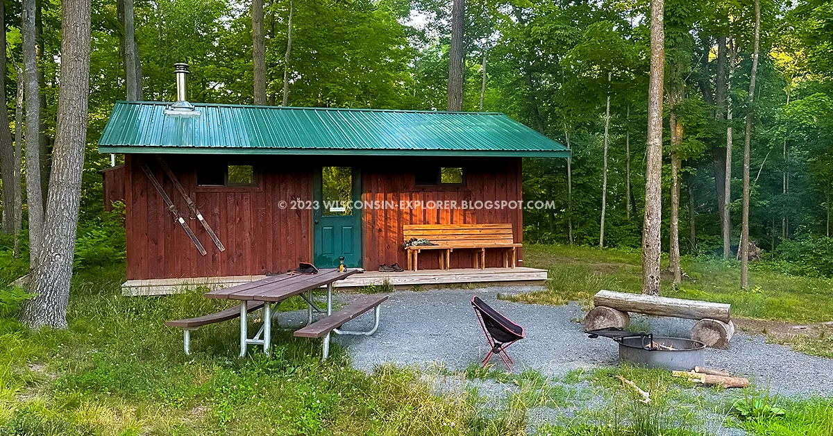
The Timberland Ski Area hosts a long segment of the Ice Age National Trail. The trail club invested in a camper cabin that they rent as a ski-in/ski out cabin in the winter and a trail cabin in the spring, summer, and fall. The cabin, reserved on Airbnb, is 2-miles in on the Ice Age Trail from the nearest parking lot and about midway along the Timberland Hills Segment. There's no drinking water there, but there is a pond to filter from. Otherwise, it includes a wood burning stove, four bunks, firewood, a fire pit, an outhouse, and a picnic table. If you can shuttle hike this trail, you'll be able to knock out the Sand Creek Segment and Timberland Hills in one weekend.
2 DAY/1-NIGHT ITINERARY
BEFORE ARRIVAL: Reserve the Burnette County Unique Camper Cabin
DAY 1 (10.5-Miles):
Park a vehicle at the IAT Grassy Lake West trailhead on Pershing Road then drive to the IAT Sand Creek Trailhead on 15th Ave. Hike 5.5-miles heading eastbound. Complete the IAT Sand Creek Segment and follow the short road connection to the Timberland Hills Segment trailhead. Hike eastbound for five more miles to reach the unique camper cabin.
DAY 2 (7-miles):
Continue hiking eastbound to complete the IAT Timberland Hills Segment and take the connecting road routes to the IAT Grassy Lake Trailhead.
ICE AGE TRAIL - TIMBERLAND HILLS SEGMENT ARTICLE
ICE AGE TRAIL - SAND CREEK SEGMENT ARTICLE
ICE AGE TRAIL - GRASSY LAKE SEGMENT ARTICLE
Unforgettable Multi-Day Hikes
Backpacking is about the journey. By your third day on the trail, you'll feel tired - but fully immersed in an experience that engages your whole body, mind, and spirit. Add social bonding to the mix as you and your group pull together to meet the challenges of the trail and you have the makings of lifetime memories. No matter the weather or the conditions you'll look back and either laugh at the difficulties you endured or warmly reminisce about how everything just seemed to line up.The next set of hiking recommendations comes from my own store of most-memorable-adventures-past - some group hikes and others as solo treks.

North Country Trail - Foster Falls To Copper Falls
DIFFICULTYINTERMEDIATE
TOTAL MILES
23-MILES POINT-TO-POINT
REGION
UP NORTH (NORTHERN WOODLANDS)
COUNTY
IRON AND ASHLAND COUNTIES
NEARBY COMMUNITIES
GURNEY, MELLEN
CAMPING TYPE
Reserved remote campsite in Copper Falls SP, Designated dispersed camp area, first-come-first-served primitive campsites, non-designated dispersed camping allowed anywhere in the Iron County Forest.
AMMENITIES
Grass, gravel, and paved off-street parking lots; paved and gravel access roads; primitive toilets near designated primitive sites; brief bench tables at designated primitive sites; stone and earth fire rings at designated primitive campsites; access to river water for filtering is abundant and frequent
WHAT YOU'LL LOVE ABOUT THIS HIKE
Hopping between three waterfalls with short climbs to overlooks in-between.
SIGHTS ALONG THIS HIKE
Foster Falls, Potato River, Upson Lake Overlook, Old Goldmine, Casey Overlook, Tyler Forks River, Wren Falls, Iron County Forest, Porcupine Hill, Bad River, Brownstone Falls, Copper Falls, Observation Tower, Doughboy's Trail, Loon Lake
WILDLIFE
Black Bears, Coyote, Wolves, Songbirds, Owls
A route full of delights and relatively easy hiking, the NCT follows the Potato River before jumping over to the Tyler Forks and Bad Rivers. You'll feel like you're on a journey as you find plenty of reasons to stop at overlooks, waterfalls, historic sites, curiosities, and just a really beautiful and wild forest. The campsites provided by the NCT trail volunteers are some of the most beautiful free backpacking campsites in the state. Dispersed camping is open anywhere in the Iron County Forest which will be anywhere between Foster Falls the west side of Porcupine Hill - and there are plenty of fine areas where you can sling a hammock for the night. The route finishes in Copper Falls State Park at the Doughboy's loop where you'll be treated to a pair of postcard worthy waterfalls and an observation tower poking up just above the trees. The cost of this trip is free - if you use the dispersed campsites. A small fee and reservation is needed if you want to use the Copper Falls remote backpacking campsite.
3 DAY/2-NIGHT ITINERARY
BEFORE ARRIVAL:
Reserve the North Hikers Campsite at Copper Falls State Park for night 2.
DAY 1 (9-miles):
Park a vehicle in Copper Falls State Park and then drive another car over to Foster Falls. Hike westbound along the Potato River and make stops at two overlooks and an old goldmine before arriving at Wren Falls. Just past Wren Falls take the footbridge across Tyler Forks River and camp at the primitive campsite on the west side of the bridge.
DAY 2 (12-miles):
Start by hiking up Porcupine Hill and then descend to cross the Tyler Forks River on the west side of Porcupine Hill. Cross through wetlands on boardwalks before crossing Highway 169. After a long straight walk you'll see the Dispersed Camping Area. You'll catch some good views of the Bad River from the bluffs before reaching the Copper Falls North Hikers Campsite.
DAY 3 (2-5 Miles):
It's less than 2-miles to reach Brownstone Falls where the Tyler Forks River joins the Bad River in a stone canyon. The Doughboys Loop circles around this scenic area and you can take the CCC trail to the top of a hill and climb the observation tower. Hike the remaining distance to where you parked.
NORTH COUNTRY TRAIL - FOSTER FALLS SEGMENT ARTICLE
NORTH COUNTRY TRAIL - PORCUPINE HILL SEGMENT ARTICLE
NORTH COUNTRY TRAIL - COPPER FALLS SEGMENT ARTICLE

North Country Trail - Penokee to Two Lakes
DIFFICULTYINTERMEDIATE
TOTAL MILES
34-MILES POINT-TO-POINT
REGION
UP NORTH (NORTHERN WOODLANDS)
COUNTY
ASHLAND AND BAYFIELD COUNTIES
NEARBY COMMUNITIES
MORSE, MARENGO, DRUMMOND
CAMPING TYPE
Beaver Lake and Two Lakes drive-in campgrounds, two designated first-come-first-serve trail shelters, first-come-first-served non-desiganted primitive campsites, non-designated disperesed camping allowed on national forest Properties (at most, but not all locations along the trail - knowledge of forest rules and boundaries required).
WHAT YOU'LL LOVE ABOUT THIS HIKE
A true journey through the heart of the Chequamegon Forest.
SIGHTS ALONG THIS HIKE
Penokee Overlook, Trout Brook, English Lake Hemlocks State Natural Area, Brunsweiler River and Mineral Lake State Natural Area, Hanson Overlook, Hanson Field, Brunsweiler State Wild River, Lake Three, Spring Brook, Beaver Lake, Whiskey Creek, Swedish Settlement, Marengo River, Juniper Overlook, Longmile Lookout, East and West Davis Lakes, North Country Trail Hardwoods State Natural Area, Porcupine Lake Federal Wilderness, Porcupine Lake, Eighteen Mile Creek, Eighteen Mile Creek State Natural Area
WILDLIFE
Loons, Owls, Black Bear, Wolves, Elk, Beaver, White Tailed Deer, Woodpeckers and Songbirds including many rare species AMMENITIES
Grass and gravel off-street parking lots; paved and gravel access roads; potable water at Beaver Lake Campground; at least once daily access to stream and lake water for filtering; two designated timber trail shelters
This route has all the makings of trail magic if conditions are right. Each day you will immerse yourself in the deepest of Wisconsin's forest. Broad swaths of mature hardwood forest turn vivid with color in the fall and stands of boreal pine species keep the forest green in winter and spring. Daily hikes are challenging in this hilly terrain interrupted by random stone outcroppings and hops over streams. It is possible to break this proposed trip down into shorter hiking days or extend the plan to pack on miles. Wilderness campers will love the deep woods' primitive camping options that abound.
5 DAY/4-NIGHT ITINERARY
DAY 1 (2-miles) Travel Day:
Park a vehicle in the small 4-car lot off Porcupine Road FR213 near the trailhead for the Porcupine Lake Wilderness Segment (You'll see the federal wilderness sign). Drive a 2nd vehicle to the Penokee Ski Trails lot on Ashland County GG. Hike 2-miles on wide two-track XC ski trails to reach the Penokee Warming Shelter. Disperse camp near the shelter.
DAY 2 (11-miles):
You'll get a chance to fill up with water at a heavy flowing stream less than a mile westbound from the Penokee Shelter. Hike past an overlook, through Hanson Field, across the Brunsweiler River, and past Lake Three. Camp at the Beaver Lake drive in campground or continue on 1.5 miles and dispersed camp near Whiskey Creek.
DAY 3 (7-Miles):
Hike shorter miles on Day-3 and enjoy time relaxing on Juniper Overlook and exploring the historic Swedish Settlement. Camp near the Marengo River Shelter or dispersed camp in the pine plantation near Sallygirl Overlook.
DAY 4 (11-Miles):
Hike to the top of Longmile Lookout then down to East Davis Lake. Cross through jungle-like terrain in the Porcupine Lake Wilderness to reach Porcupine Lake where you will find two primitive campsites, one near the lake and one up the hill from the lake.
DAY 5 (2.5-Miles) Travel Day:
Hike out, retrieve vehicles and travel home.
NORTH COUNTRY TRAIL - PENOKEE TO BEAVER LAKE ARTICLE
NORTH COUNTRY TRAIL - TWO LAKES TO LAKE THREE ARTICLE

North Country Trail - Lake Owen through Rainbow Lake Wilderness
DIFFICULTYINTERMEDIATE
TOTAL MILES
21-MILES POINT-TO-POINT
REGION
UP NORTH (NORTHERN WOODLANDS)
COUNTY
BAYFIELD COUNTY
NEARBY COMMUNITIES
DRUMMOND
CAMPING TYPE
First-come-first-serve non-designated primitive campsites, non-designated disperesed camping allowed on national forest Properties (at most, but not all locations along the trail - knowledge of forest rules and boundaries required).
WHAT YOU'LL LOVE ABOUT THIS HIKE
Easy hiking to peaceful primitive campsites
SIGHTS ALONG THIS HIKE
Lake Owen, Melland Pond, Lake Owen Hardwoods State Natural Area, Drummond Ski Trails, Drummond Woods State Natural Area, Long Lake Branch Creek, Overby Lake, Esox Lake, Mirror Lake, Nelson Lake, Stratton Ponds, Wishbone Lake, Reynard Lake, Bufo Lake, Rainbow Lake, Tower Lake, Rainbow Lake Federal Wilderness
WILDLIFE
Loons, Owls, Black Bear, Wolves, Beaver, White Tailed Deer, Woodpeckers and Songbirds including many rare species AMMENITIES
Paved off-street parking lots; paved and gravel access roads; potable water at Lake Owen Picnic Grounds; multiple daily access to stream and lake water for filtering
This peaceful forest, easy trail, and outstanding primitive campsites will make you want to return and rehike this trail several times. The two campsites mentioned in the plan below are among the best sites in the entire state - please take loving care of them and pitch in to help carry out left behind trash and keep the sites clean and natural for the next hiker.
3 DAY/2-NIGHT ITINERARY
DAY 1 (6-miles) Travel Day:
Park a vehicle in the small 3-car lot off West Delta Road FR228 across from the trailhead for the Rainbow Lake Wilderness Segment (You'll see the federal wilderness sign). Drive a 2nd vehicle to the Lake Owen Picnic Grounds. Hike a spur trail to Melland Pond and then turn north to follow the NCT through the Drummond Ski Trails. Cross Highway 63 and enter Drummond Woods where there are a few old growth white pine trees. Continue downhill to Long Lake Branch Creek and camp at the primitive campsite there.
DAY 2 (8-miles):
Hike through hilly terrain past a number of lakes and enter the Rainbow Lake Wilderness. The trail becomes flat and easy in the wilderness. Turn off on the Anderson Grade Trail and head westbound to reach the Anderson Lake primitive campsite (which will take some patience and searching to find).
DAY 3 (7-Miles):
Hike back to the North Country Trail and head north and hike past Rainbow and Tower Lake before finishing your trip.
NORTH COUNTRY TRAIL - DRUMMOND SKI TRAILS ARTICLE
NORTH COUNTRY TRAIL - DRUMMOND AREA AND RAINBOW LAKE ARTICLE

North Country Trail - Ruth Lake to Brule/St. Croix Portage
DIFFICULTYINTERMEDIATE
TOTAL MILES
31-MILES POINT-TO-POINT
REGION
UP NORTH (NORTHERN WOODLANDS)
COUNTY
BAYFIELD AND DOUGLAS COUNTY
NEARBY COMMUNITIES
IRON RIVER, BRULE, SOLON SPRINGS
CAMPING TYPE
Camping is restricted to first-come-first-serve designated primitive campsites.
WHAT YOU'LL LOVE ABOUT THIS HIKE
Easy hiking between excellent primitive campsites.
SIGHTS ALONG THIS HIKE
Erick Lake, Morris Pond, Winneboujou Bluff, Brule River State Forest, Motts Ravine State Natural Area, Highland Town Hall and Park, Jersett Creek, Brule Glacial Spillway State Natural Area, Historic Brule St Croix Portage Trail, Historic Memorial Stones
WILDLIFE
Owls, Black Bear, Wolves, White Tailed Deer, Porcupine. AMMENITIES
Gravel and grass off-street parking lots; paved and gravel access roads; designated primitve campsites have breift bench table, stone fire rings, and thunderboxes nearby; artesian well nearby at Brule River Campground.
This route generally descends elevation over its four days as hikers roll along gentle terrain towards the Brule River valley. This working forest will have you hiking through cutover land - but the upside is that you'll get sunshine and breezes in between hikes in the deep shade of pine plantations. There are six outstanding primitive campsites along this trail where you can relax and enjoy the forest. The trail and woods become wilder as you approach the Brule River, and the hike finishes out on one of the most historic footpaths in the United States. It may well be the oldest footpath still being used as such.
4 DAY/3-NIGHT ITINERARY
DAY 1 (4.6-miles):
Park a vehicle at the St Croix Lake Boat Landing (Palmers Landing Park). On your drive over, consider stopping at the Rush Lake Road Trailhead just off Highway 27 - Stash a gallon of drinking water there - You may need it on Day 2. Drive a 2nd vehicle to the Ruth Lake Trailhead at Bayfield County Highway A. Cross the highway and head westbound on the North Country Trail towards Erick Lake. Stop to fill up with water at Erick Lake then continue on to the campsite at Morris Pond.
DAY 2 (12-miles):
Continue westbound for 7-miles to reach the Winneboujou Bluff Campsite. If you need drinking water and did not stash any at a trailhead you will have the opportunity to take a 1-mile out and back down and back up a hill to a stream from the Winneboujou Bluff. That could be your last chance to filter drinking water until Jersett Creek. Continue south on the trail in a gradual decline for 5-miles to reach the Paul Schoh Campsite. Along the way, you'll pass the Rush Lake Road Trailhead and you can retrieve your stashed drinking water from Day-1.
DAY 3 (9.5-Miles):
Continue south from Paul Schoh Campsite and cross Highway 27 at Gaylord Nelson Portal and continue for 7 miles to Highland Town Hall. Do not expect to find drinking water at the Town Hall. Head south across County S for another 2.5 miles. You'll notice a change in the trail and surrounding forest as you approach the Brule River Valley. The Jersett Bluff Campsite is on top of a conical hill in an aspen grove. A strong running creek is in the valley just south of the campsite.
DAY 4 (5-Miles):
Hike south along the NCT for 2.5 miles to reach the historic portage put-in. Over the next 2-miles you'll note memorial stones recognizing voyageurs, missionaries, and traders who led historic expeditions on this portage between the Brule River and the St. Croix River. Cross County A and follow the white blazed trail to the St Croix Lake Boat Launch to complete your hike.
NORTH COUNTRY TRAIL - ERICK LAKE SEGMENT
NORTH COUNTRY TRAIL - BRULE RIVER STATE FOREST SEGMENT
NORTH COUNTRY TRAIL - HISTORIC BRULE ST CROIX PORTAGE TRAIL

Ice Age Trail Trail - Mondeaux Esker Through Lake Eleven Segments
DIFFICULTYINTERMEDIATE
TOTAL MILES
34-MILES POINT-TO-POINT
REGION
CENTRAL
COUNTY
TAYLOR COUNTY
NEARBY COMMUNITIES
RIB LAKE
CAMPING TYPE
First-come-first-serve primitive campsites, reservable drive-in campsites at Mondeaux Recreation Area, non-designated dispersed camping allowed in most locations along this described route.
WHAT YOU'LL LOVE ABOUT THIS HIKE
Challenging hiking in a Northern mesic jungle.
SIGHTS ALONG THIS HIKE
Mondeaux Flowage, Mondeaux Dam Lodge, Spearhead Point, Picnic Point, Chequamegon National Forest, Mondeaux Hardwoods State Natural Area, North Fork of the Yellow River, Chippewa Lobe Loop Trail, Lost Lake Esker State Natural Area, Sailor Creek, Jerry Lake, Richter Lake Hemlocks State Natural Area, Lake Eleven, Perkinstown Hemlocks State Natural Area, Beaver Creek
WILDLIFE
Owls, Sandhill Cranes, Beavers, Black Bear, Wolves, White Tailed Deer, Porcupine AMMENITIES
Gravel and grass off-street parking lots; paved and gravel access roads; artesian well nearby at Mondeaux Recreation Area; Nearby Mondeaux Dam Lodge provides a 24-hour access coin-op shower, beach, restaurant, shelter, and boat rentals; Spearhead Point Campground has a strong timber shelter that is a suitable emergency shelter in a thunderstorm.
Covering the Mondeaux Esker, Jerry Lake, and Lake Eleven segments, this route courses on the only segments of the Ice Age Trail to cut through the Chequamegon National Forest. Forest bathers will delight in this mature northern mesic forest located in Central Wisconsin. The trails roll up and down in dramatically hummocky fashion - frequently dipping into long areas soaked and swampy. Hiking through these extended mud pits will add time to your daily trips and will rapidly drain your leg strength. You'll come away sweat drenched, mud caked, and stronger.
4 DAY/3-NIGHT ITINERARY
DAY 1 (7.5-miles):
Park at the Lake Eleven Trailhead parking area off Highway 64 and shuttle back to the beach area at Mondeaux Dam Recreation Area. Hike 5-miles to complete the Mondeaux Dam Segment at Mondeaux Drive. Then hike on the Jerry Lake Segment for 2.5-miles to reach an unnamed lake near where the White Birch Trail intersects the IAT where you may find three established primitive campsites. These sites are off the trail, so you will have to scout them out.
DAY 2 (9-miles):
Hike the Jerry Lake Segment to the South Fork of the Yellow River primitive campsite. This is an exceptional campsite at a bend in the river and directly trailside.
DAY 3 (9-Miles):
Hike to Jerry Lake and proceed onto the Lake Eleven Segment. Hike to Lake Eleven where you will find two primitive campsites on opposite ends of the lake.
DAY 4 (9-Miles):
Complete the remaining 9-miles to reach the Lake Eleven Segment trailhead and parking area.
LAKE ELEVEN SEGMENT ARTICLE
JERRY LAKE SEGMENT ARTICLE
MONDEAUX ESKER SEGMENT ARTICLE
Ice Age Trail Segment Eaters
There's thousands of would-be Thousand-Milers who start ticking off IAT segments in the Southern counties where trails are shorter, easier, and easier to reach. When it comes time to travel to destination hikes in the North Central and Western regions of the state it's time to get a hiking partner willing to drive the distance separately, a backpack, and a few days off so you can bag as many segments as possible in each trip.Here's a look at how some of the Central and Western Ice Age Trail segments can tie together into backpacking trips.

Ice Age National Trail: Highland Lakes Through Kettlebowl
DIFFICULTYADVANCED
TOTAL MILES
36-MILES POINT-TO-POINT
REGION
NORTHERN
COUNTY
LANGLADE COUNTY
NEARBY COMMUNITIES
ANTIGO
CAMPING TYPE
Reserved remote and drive-in campsites, dispersed camping allowed along the Lumbercamp Segment
WHAT YOU'LL LOVE ABOUT THIS HIKE
The amazing Jack Lake Campground and campsite at Game Lake
SIGHTS ALONG THIS HIKE
Deep Wood Lake, Susan Lake, Alta Lake, Old Railroad, Jack Lake XC Ski Trails, Jack Lake Campground, Jack Lake, Game Lake, Upper Ventor Lake, Ventor Lake, Peters Marsh Wildlife Area, Norem Lumbercamp, Baker Lake, Kettlebowl Ski Area, Big Stone Hole, Kent Lookout, Frost Pocket, Norem Sheep Farm
WILDLIFE
Loons, Owls, Bitterns, Coyote, Wolves, White Tailed Deer AMMENITIES
Paved, gravel, and grass off-street parking lots; paved and gravel access roads; Leopold benches along trail; Jack Lake Campground includes potable water, drive-in campsites, reservable cabins, electric sites, coin-op showers, flush toilets;
The trails in Langlade County tend to be two-track forest roads that are clear and easy to walk. You can let your guard down and look up from the ground and around at the trees and listen to the songbirds. There are some interesting portions of the trail on the Summit Moraine Segment and towards the end of the Lumbercamp Segment. Otherwise, this route is mundane and repetitive. Advanced skills are required as you will have to camp in a non-designated dispersed area on Night-2, will need to be experienced in water management, carry extra water weight, be able to purify water from still lakes, and be able to hike for long days. Most beginners struggle to hike 10-mile days, so please consider that before choosing this route.
3 DAY/2-NIGHT ITINERARY
DAY 1 (9-miles):
On day-one, Park at the Kettlebowl off-street parking lot with room for 30 vehicles then drive a 2nd vehicle to the Deep Wood Lake Wayside off forest road and park int the off-street parking lot with room for 4 vehicles (do not block the lane through). Hike 1/8-mile south to reach the Ice Age Trail and head eastbound on the trail. Pass through the Girl Scout Camp and keep going along the easy dirt road trail route. Take Highway B 1/4-mile south to connect to the trail heading east and then cross Highway 45. -Continue eastbound through the ski area until you reach County-J. Take County J south and enter the Veteran's Memorial Park and hike through the Jack Lake Campground to the Game Lake Remote Campsite. Water and showers are available at the Jack Lake Campground.
DAY 2 (14-miles):
The trail is easy, but the miles are long. Hike eastbound to complete the Summit Moraine Segment. Stop at the designated dispersed campsite and fill up with water for the rest of the day and night when passing Upper Ventor Lake. Cross Highway A and begin the Lumbercamp Segment through Peter's Marsh. Cross County S and continue on the Lumbercamp Segment for another 4-miles before reach the Norem Lumbercamp. Camp in the field beside the Hillbilly Hilton. No nearby water sources available.
DAY 3 (13-Miles):
The trail descends a long hill, which can only mean a long uphill to follow. After crashing through some rough trail you'll reach Baker Lake where you can filter water for the day. Finish the hill climb and reach Kettlebowl. Then enjoy the long downhill for the next 10.5-miles to the parking lot.
IAT EAST HIGHLAND LAKES SEGMENT ARTICLE
IAT SUMMIT MORAINE SEGMENT ARTICLE
IAT LUMBERCAMP SEGMENT ARTICLE
IAT KETTLEBOWLSEGMENT ARTICLE

Ice Age Trail - Grandfather Falls Through New Woods
DIFFICULTYINTERMEDIATE
TOTAL MILES
17-MILES POINT-TO-POINT
REGION
CENTRAL
COUNTY
LINCOLN COUNTY
NEARBY COMMUNITIES
TOMAHAWK
CAMPING TYPE
First-come-first-served primitive campsites, reservable drive-in campsites, non-designated dispersed camping in some areas.
WHAT YOU'LL LOVE ABOUT THIS HIKE
Scenery along the Wisconsin River is exceptional.
SIGHTS ALONG THIS HIKE
Camp New Wood County Park, Wisconsin River, Grandfather Dam Hydroelectric Facility, Grandfather Falls, Turtle Rock, New Wood River, Kelly Creek, Averill Creek, Camp 26 Creek, New Wood Public Hunting Grounds
WILDLIFE
Owls, Herons, Beavers, Black Bear, Wolves, White Tailed Deer AMMENITIES
Paved, gravel, and grass off-street parking lots; paved and gravel access roads; Leopold benches along trail.
The Grandfather Falls Segment is an easy hike on a popular trail along a scenic section of the Wisconsin River. There is a long road connection to the Turtle Rock Segment where the trail turns into a wilderness adventure. There is a section of the Turtle Rock Segment that crosses a boulder field along the Wisconsin River where the trail is difficult to follow. Then it cuts uphill on a faint and narrow footpath. You’ll find an adequate campsite at Burma Road which is not close to water sources, next to a road, and not scenic at all. The trail continues across Burma Road onto the Averill-Kelly Creek Segment which cuts through dense woods on private property. Hikers must ford the Kelly Creek and the Averill Creek. The New Woods Segment is easier going on a trial with good tread through the massive New Wood State Wildlife Area. Mosquitoes, ticks, bears, and wolves thrive in this dense and remote woodland.
3 DAY/2-NIGHT ITINERARY
DAY 1 (9-miles):
Park at the Camp 27 trailhead off Conservation Ave, then shuttle back to the New Woods County Park on Highway 107. Head North following the IAT along the Wisconsin River for 3-miles. Then follow Highway 107 for ¾-Mile to reach County E and take the bridge over the Wisconsin River and turn left to stay on County E for 1-mile to reach the Turtle Rock Segment. Follow the Turtle Rock Segment south and then west to reach a primitive dispersed camp area at Burma Road.
DAY 2 (8-miles):
On day-two, complete the 5-miles of the Averill-Kelly Creek Segment. Then head north for a few blocks on Lincoln County Rd E to reach the New Wood Segment. Hike 2.5-miles to the northernmost hook of New Woods Segment. From this hook hike north off the trail to find the New Wood River and there will be adequate space in the area to set up a primitive campsite.
DAY 3 (4-Miles):
On day-three, complete the remaining four miles of the New Wood Segment.
IAT GRANDFATHER FALLS SEGMENT ARTICLE
IAT TURTLE ROCK SEGMENT ARTICLE
IAT AVERIL KELLY CREEK SEGMENT ARTICLE
IAT NEW WOODS SEGMENT ARTICLE

Ice Age National Trail: New Woods Segment to Mondeaux Esker Segment
DIFFICULTYADVANCED
TOTAL MILES
45-MILES POINT-TO-POINT
REGION
CENTRAL
COUNTY
LINCOLN AND TAYLOR COUNTIES
NEARBY COMMUNITIES
RIB LAKE
CAMPING TYPE
FIRST-COME-FIRST-SERVE PRIMITIVE CAMPSITES, RESERVABLE DRIVE-IN CAMPSITES, DISPERSED CAMPING IN SOME AREAS
WHAT YOU'LL LOVE ABOUT THIS HIKE
Rustic trail through the wilder side of the Ice Age Trail.
SIGHTS ALONG THIS HIKE
New Woods State Wildlife Area, Wood Lake County Park, New Wood Creek, Gus Johnson Creek, Rusch Preserve, Rib Lake Ski Club, Moose Mountain, East Lake, Pine Line State Trail, Fisher Creek, Mondeaux Flowage. Mondeaux Dam Lodge.
WILDLIFE
Owls, Beavers, Black Bear, Wolves, White Tailed Deer, coyote, Bald Eagles, Loons
AMMENITIES
Paved, gravel, and grass off-street parking lots; paved and gravel access roads; Leopold benches along trail.
The routes of the Ice Age Trail in Lincoln and Taylor Counties are among the most remote segments of the overall trail. This is an opportunity for immersion in the wilderness. Unfortunately, there are longer distances between camping areas and a few lengthy road connections. This 4-day backpacking trip covers, from east to west, the Camp 27, Timberland, Wood Lake, Rib Lake, East Lake, Pine Line, and half of the Mondeaux Esker segments of the Ice Age Trail.
4 DAY/3-NIGHT ITINERARY
DAY 1 (12-miles):
Park at the main beach area and lodge at Mondeaux Dam Recreation Area., then shuttle to the Camp 27 Segment trailhead off Conservation Ave. Complete the New Wood Segment and Camp 27 Segment. Refill with water at the river ford over the North Branch of the Copper River before finishing the Camp 27 Segment. Hike 2-miles west on Tower Road to reach the trailhead for the Timberland Wilderness Segment and complete that segment, then on to the Wood Lake Segment and Camp in the Wood Lake Campground.
DAY 2 (12-miles):
Proceed westbound along the Ice Age Trail Wood Lake Segment. Cross Highway 102 to begin the Rib Lake Segment. Camp at the Stille Nacht Campground on the Rib Lake Segment. Your Day-2 hike will be 12-miles. There is a water pump at Stille Nacht.
DAY 3 (11-Miles):
Complete the Rib Lake Segment. then take the short road walk to the East Lake Trailhead and complete the East Lake Segment, fill up with water at the wayside and hike south along Highway 13 for 0.62-miles. Be very attentive as the Pine Line Segment trail sign is set off from the road among tall grass and shrubs. Take the Pine Line Segment ¼-mile to reach the Eagle Scout primitive campsite. Total hike for Day-3 is 11-miles.
DAY 4 (11-Miles):
Finish the Pine Line Segment and hike 3.6 miles west along Fawn Ave to reach the trailhead for the Mondeaux Esker Segment at the intersection with Bunker Road. (Before hiking down Fawn Ave you may want to take a 1-mile out-and-back side trip to Chelsea Lake Park after finishing the Pine Line Segment to retrieve water from a water pump there as there are no reliable water sources for the next 8-miles). Hike 6 more miles westbound along the Mondeaux Esker Segment to reach the Mondeaux Dam Recreation Area parking lot.
CAMP 27 ARTICLE
TIMBERLAND WILDERNESS ARTICLE
WOOD LAKE ARTICLE
RIB LAKE ARTICLE
EAST LAKE ARTICLE
PINE LINE ARTICLE

Ice Age National Trail: Chippewa Moraine to Chippewa River Segments
DIFFICULTYINTERMEDIATE
TOTAL MILES
18.5-MILES POINT-TO-POINT
REGION
NORTHERN
COUNTY
CHIPPEWA COUNTY
NEARBY COMMUNITIES
CORNELL
CAMPING TYPE
FIRST-COME-FIRST-SERVE PRIMITIVE CAMPSITES, DISPERSED CAMPING IN SOME AREAS
WHAT YOU'LL LOVE ABOUT THIS HIKE
Rolling woodland hills beside picturesque small lakes and wetlands.
SIGHTS ALONG THIS HIKE
Horsehoe Lake, North of North Shattuck Lake State Natural Area, North Shattuck Lake, Ice Age National Scenic Reserve, Chippewa County Forest, Knickerbocker Lake, Dam Lake, Dumke Lake, Plummer Lake, Chippewa Moraine Lakes State Natural Area, Harwood Lakes, Deer Lake, Picnic Lake, Firth Lake
WILDLIFE
Owls, Beavers, Black Bear, White Tailed Deer, coyote, Loons
AMMENITIES
gravel off-street parking lots; paved and gravel access roads; Leopold benches along trail.
This hike is among the backpacking trips I recommend most often. It's a great wilderness hike that is easy to reach and has scenic primitive campsites along the trail. The Chippewa Moraine is a hilly area that is dotted with lakes. The first day of this hike hops from lake to lake and lands at a picture perfect campsite on a narrow isthmus between the two Harwood Lakes. Fishermen will love camping here. The next day brings hikers deep into wilderness forest along the Harwood Lakes Segment. There's a campsite overlooking Ruth Lake, or you can push on just a bit further to another site in the woods on the Firth Lake Segment.
The only unfortunate aspect of this set of trail segments is that a key trail connection between Firth Lake and the Chippewa River Segment is closed due to a change in property ownership. If you are up to a few miles of hiking along roads you can easily add the Chippewa River Segment to this hike. Plans are already in motion to reconnect Firth Lake and the Chippewa River with a new trail, but for now I will consider the Firth Lake boat ramp to be the end of this route.
3 DAY/2-NIGHT ITINERARY
DAY 1 (8.5-miles):
On day-one, Park at the Firth Lake boat ramp off 250th Ave and shuttle to the Chippewa Moraine Segment trailhead on 267th Ave. Hike east for 7.3-miles on the Ice Age Trail to complete the Chippewa Moraine Segment at 260th Ave. Follow 260th Ave for a short distance and then turn south on Plummer Lake Rd and walk two blocks to find the Harwood Lakes Segment Trailhead. Hike 1-mile east on the Harwood Lakes Segment to reach the primitive campsite at Harwood Lakes. Total day-1 mileage will be 8.5-miles.
DAY 2 (7.5-miles):
On Day 2 continue eastbound to complete the Harwood Lakes Segment on Chippewa County Highway E. Walk south along County E for ¾-miles. This road walk is precarious with little shoulder while the curvy road and hills will prevent vehicles from seeing pedestrians. Take care to walk against traffic and stay as far off the pavement as possible. Turn on to 245th Ave which is a wide gravel road without traffic and hike 1-mile east to reach the Harwood Lakes Segment. Follow this north hook of the trail around through some scenic wetlands and come to another intersection with 245th Ave. Hike ½-mile further along the Ice Age Trail and look for a flat clearing and primitive campsite just off the trail on your right side (south side of the trail). This campsite is less used, but ideal for backpacking. It is a short distance up the trail from a water source on a branch of the Bob River. Total day-2 mileage will be 7.5-miles
DAY 3 (2.5-Miles):
On day-3, complete 2.5-miles to return to the parking area at Firth Lake.
IAT CHIPPEWA MORAINE SEGMENT ARTICLE
IAT HARWOOD LAKES SEGMENT ARTICLE
IAT FIRTH LAKE SEGMENT ARTICLE

Ice Age National Trail: Bear Lake Segment Through Trade River Segment
DIFFICULTYADVANCED
TOTAL MILES
62.5-MILES POINT-TO-POINT
REGION
NORTHWEST
COUNTY
BARON, BURNETTE, POLK, WASHBURN
NEARBY COMMUNITIES
CUMBERLAND
CAMPING TYPE
Dispersed Camping is required on this route, Reserved campsites at Straight Lake, and a reserved trail cabin at Timberland Hills
WHAT YOU'LL LOVE ABOUT THIS HIKE
Interesting diversity of camping experiences
SIGHTS ALONG THIS HIKE
Bear Lake, Camp Phillips, Bass Lake, Bear Lake State Fishery, Leaman Lake, Grassy Lake, Washburn County Forest, Barron County Forest, Timberland Hills Ski Area, Clam River South Fork, Burnett County Forest, Sand Creek, Sand Creek State Fishery Area, Dinger Lake, Mckenzie Creek State Wildlife Area, Clam River, Mckenzie Creek, Tula Lake State Natural Area, Mckenzie Lake, Straight River, Straight Lake, Tunnel Channel Woods State Natural Area, Straight Lake Tamarack Fen State Natural Area, Big Basalt Rock, Trade River,
WILDLIFE
Owls, Beavers, Black Bear, White Tailed Deer, coyote, Loons, Trumpeter Swans
AMMENITIES
Paved, gravel, and grass off-street parking lots; paved and gravel access roads; Leopold benches along trail; vault toilets at Straight Lake Campground; campsites at Straight Lake campground include fire rings with grills and picnic tables.
Separated by short road connections, the set of IAT segments in the Northwest portion of the trail form a chain of footpaths that carry through county forests. The key to this hike is managing water as many ponds are covered by algae with the potential for toxic blue-green algae blooms and streams shown on maps are often dry beds. When it is available, filter enough water for a full day plus and carry it. This advanced-level hike requires backpackers to: hike off the trail to camp in non-designated dispersed campsites where LNT is mandatory, be experienced with drinking water testing, purifying, and management along with the ability to carry multiple liters each day, hike long miles in hilly terrain for multiple days, and navigate along connecting road routes for miles in areas with low quality cell service. Athletic hikers may combine days to accomplish the hike in a shorter time, but beware, areas along this route that are ammeanable to non-designated camping can be difficult to locate.
7 DAY/6-NIGHT ITINERARY
BEFORE ARRIVAL:
Make two reservations: The first for your 2nd night at the Unique Camper Cabin in the Burnette County Forest. The second for your last night (Day-6) for a hike-in campsite at Straight Lake State Park. Sites #7, #5, and #9 are excellent - but all others are good.
DAY 1 (9-miles):
On day-one, Park at the Trade River Segment lot on 140th street where there is off-street parking for a dozen vehicles, then return in another vehicle to the east trailhead for the Bear Lake Segment on Highway VV just outside Camp Phillips and park in an off-street lot with room for 6 vehicles. Bring enough water for 1 1/2 days. Hike westbound through Camp Phillips and Cub World then through rougher terrain leading up to Shallow Lake Road. Take Shallow Lake Rd North to 30th Ave and and hike 1/4-mile west to reach the Grassy Lake east trailhead. Hike on easy trail to about mid-way on this segment and find a series of wooded hills above wetlands in view that I have identified with a tent icon on my maps. The hill to the south of the trail is suitable for dispersed camping, however, the next water source is a mile west at Leaman Lake. The woods between here and the west end of Grassy Lake Segment are thickets or wetlands and not suitable for camping.
DAY 2 (13-miles):
Continue to Leaman Lake and filter enough water for a few hours. Complete the Grassy Lake segment and follow a 2.5-mile road walk on low traffic rural roads. From the east trailhead for Timberland Hills hike on easy and wide trails for an additional 5-miles. There are small lakes and ponds that you can filter water from - including the Clam River North Branch. Reach the Unique Camper Cabin you reserved and enjoy the stay in a hard-walled shelter. The pond near the cabin isn't the best looking water source and there is a large farm that drains to it - so beware of blue green algae blooms.
DAY 3 (9-Miles):
Finish the Timberland Hills Segment. There are plenty of small lakes to filter water from along the trail. Take the short road connection to the Sand Creek Segment and hike more than half of this segment. You'll cross Sand Creek on a large wood decked ATV bridge. After the bridge you will find a pine plantation on a small rise. Walk off the trail to the northeast and before you hit Sand Creek again you'll find an area in the pine plantation where you can disperse camp. There will be enough flat soft ground to set up a tent, plenty of trees for a hammock, as well as privacy in the pine thicket, and access to Sand Creek for water.
DAY 4 (8-Miles):
Fill up with a day's worth of water from Sand Creek and depart. Finish the Sand Creek Segment and then take the short road walk to the Indian Creek Segment. Complete the Indian Creek Segment and cross Highway O to begin the Mckenzie Creek Segment. The first mile of Mckenzie Creek Segment passes through a State Ice Age Trail Area (SIATA) where dispersed camping is allowed. Non-designated dispersed camping areas become scarce going forward - so the area here off the trail near a pond in a pine plantation is your last chance for legal camping before the next designated primitive campsite 12-miles further along the route. The Clam River - 1-mile to the west where the IAT crosses on a wood foot bridge - is the closest best source for filtering drinking water.
DAY 5 (12-Miles):
It won't be long before you encounter Mckenzie Creek which is a good source for drinking water. Before completing the Mckenzie Creek Segment fill up with a day and half's worth of water filtered from Mckenzie Lake. Continue through the Mckenzie Creek Segment and then on the short road walk to the Pine Lake Segment and take the Pine Lake Segment - through a cow pasture - to Highway 48. At a trail parking lot off 95th Street you'll find a designated primitive campsite on a small hill overlooking a pond. There's a lot of agriculture in the area and thus a lot of manure in the water - beware of potential blue-green algae blooms on this pond and at the designated Dispersed Camping Area on Long Lake.
DAY 6 (7-Miles):
Complete the Straight River Segment and follow the short road walk to the Straight Lake Segment. Hike to a reserved campsite on the south end of Straight Lake. Filter water from Straight Lake.
DAY 7 (4.5-Miles):
Complete the Straight Lake Segment and more than half of the Trade River Segment and arrive back at the parking lot on 140th St.
IAT BEAR LAKE SEGMENT ARTICLE
IAT GRASSY LAKE SEGMENT ARTICLE
IAT TIMBERLAND HILLS SEGMENT ARTICLE
IAT SAND CREEK SEGMENT ARTICLE
IAT INDIAN CREEK SEGMENT ARTICLE
IAT MCKENZIE CREEK SEGMENT ARTICLE
IAT PINE LAKE SEGMENT ARTICLE
IAT STRAIGHT RIVER SEGMENT ARTICLE
IAT STRAIGHT LAKE SEGMENT ARTICLE
IAT TRADE RIVER SEGMENT ARTICLE
Bonus: Backpacking Beyond Wisconsin
Our neighbors are the best. Minnesota, Michigan, and Wisconsin feel connected - where the people are friendly and the children are above average. We share seasons, climate and weather patterns, and forest typographies. While I'm a tireless promoter of my home state I have to admit that Michigan and Minnesota both outshine Wisconsin when it comes to backpacking trails. From the Border Route to the famed Superior Trail and across to the Porcupine Mountains and Pictured Rocks, the North Country Trail is the sinew of a backpacking culture.
Backpacking The Porcupine Moutains in Michigan's Upper Penninsula
DIFFICULTYINTERMEDIATE
TOTAL MILES
90-MILES LOOPING TRAIL NETWORK
REGION
MICHIGAN
COUNTY
ONTONAGON, GOGEBIC
NEARBY COMMUNITIES
ONTONAGON, WHITE PINE, WAKEFIELD
CAMPING TYPE
Designated primitve sites require reservations, Rustic Camper Cabins require reservations.
WHAT YOU'LL LOVE ABOUT THIS HIKE
Long looping trails spanning between high bald rock overlooks and the Lake Superior shoreline.
WILDLIFE
Loons, Owls, Eagles, Black Bears, Porcupine, Wood Peckers, Beavers
Speaking of backpacking-first culture, there's no better way to see the Porcupine Mountains Wilderness State Park than by backpacking. With 35,000 acres of old-growth forest and 90-miles of looping and interconnected trails, there are dozens of potential routes ranging from single overnights to a full week on the trail. Loops make it easy to hike this park solo or with groups. You'll know you have a campsite or cabin waiting for you at the end of each day with its unique back-country camping reservation system.
With so many potential trips available, it's difficult to determine which is the best one to recommend for the uninitiated. What I recommend is focussing on the West side of the park rather than the more popular East side. You'll have more options and diversity of experience on the West end between Summit Peak and the Lake Superior shore. This is where you'll spend the whole day hiking beside a cascading river, find the best waterfalls, the best access for swimming in Lake Superior, and trails that rise to an observation tower at Summit Peak.
The beginner route I recommend is a 4-day, 23-mile loop between Summit Peak, Mirror Lake, and The Big Carp and Little Carp Rivers. This route will give you a sample of everything the Porcupine has to offer. 4 DAY/3-NIGHT ITINERARY
BEFORE ARRIVAL:
Reserve campsite SML-3 for your first night, LC-14 for your 2nd night, LC-3 for your 3rd. DAY 1, Travel and Check-In Day (3-miles):
Drive to the park headquarters on the East side of the park on South Boundary Road. This is the only station where you can check in to get your camping permits. After checking in, Drive on South Boundary Road over to Mirror Lake Parking Area (do not take up day-visitor parking spaces at Summit Peak). Begin your hike and travel downhill to reach Mirror Lake and camp at SML-3.
DAY 2 (8-miles):
Follow the Little Carp River Trail north beside the shore of Mirror Lake and turn north on the Correction Line. Hike down a steep hill for 3-miles to reach the Big Carp River Trail. Take a left turn to hike northwest on the Big Carp River Trail for 3-miles. Along the way you will ford the Carp River and pass Shinning Cloud Falls and Bathtub Falls. At the mouth of the Big Carp River head southwest for 1.6-miles on the Lake Superior Trail to the mouth of the Little Carp River. Camp at LC-14 on the shore of Lake Superior.
DAY 3 (7-Miles):
Head south for 5-miles on the Little Carp River Trail. You’ll ford the Little Carp River twice as you hike uphill the entire day. You’ll also pass Trappers Falls, Explorer Falls, and Greenstone Falls. Just after Greenstone Falls veer left to stay on the Little Carp River Trail for two more miles. You’ll hike through some mud and uphill to reach a campsite at LC3.
DAY 4, Travel Day (5-Miles):
Hike 1.3-miles northwest on the Little Carp River trail to reach the intersection of the Beaver Creek Trail. Take the 2.3-mile steep climb up to Summit Peak then return to the parking lot on 1.5-miles of the South Mirror Lake Trail.
WISCONSIN-EXPLORER POST ABOUT THE PORCUPINE MOUNTAINS

Backpacking Isle Royale National Park
DIFFICULTYINTERMEDIATE
TOTAL MILES
36-MILE LOOP
REGION
MICHIGAN
COUNTY
KEWEENAW
NEARBY COMMUNITIES
HOUGHTON, ROCK HARBOR
CAMPING TYPE
First-come-first-serve designated primitive sites grouped in campgrounds, first-come-first-serve trail shelters.
WHAT YOU'LL LOVE ABOUT THIS HIKE
Hiking on an enchanted remote island where the night sky is full of stars and swimming each day in icy cold Lake Superior.
WILDLIFE
Loons, Owls, Eagles, Otters, Wolves, Moose, Fox
The largest island in the largest lake in the world boasts 165-miles of looping interconnected backpacking trails in a remote and otherworldly landscape. Requiring a 3.5-hour ferry ride across Lake Superior or an adventurous journey by sea plane Isle Royale is not easy to reach. Once there you'll be fully immersed in wilderness. But for a tiny sliver of civilization at the two ports of Windigo and Rock Harbor this island is a backcountry forest waiting to be explored either by foot or canoe.
When you arrive you'll have to get a backcountry camping permit and provide your expected itinerary but you'll be able to change course after starting. Campsites and shelters cannot be reserved, providing the flexibility backpackers need to respond to weather and the conditions of the trail.
To get a taste for all that this island offers try this itinerary which covers trail along the Lake Superior shoreline, up to an observation tower on the Greenstone Ridge, across the island through dense forest with high potential for moose sightings, and back across the width of the island while passing its famous inland lakes.
5 DAY/4-NIGHT ITINERARY
BEFORE ARRIVAL:
Reserve a seat on the Isle Royale Queen IV ferry boat from Copper Harbor MI to Rock Harbor on a Monday and a return trip on a Friday.
DAY 1, Travel and Check-In Day (7.5-miles):
Arrive at Rock Island and attend the mandatory orientation and check-in. Then proceed on relatively easy but uneven trail along the Lake Superior shore to the Daisy Farm Campground.
DAY 2 (9.5-miles):
Get an early start and climb the Greenstone Ridge from Daisy Farm and reach one of the highest points at Mt Ojibway. Climb the lookout tower and then spend the rest of the day slowly descending into dense forest on the north side of the island. Camp at Mcargoe Cove.
DAY 3 (8-Miles):
Reach across the island on rough trail between Chickenbone Lake and Lake Richie. Camp at either Lake Richie Campground or Moskey Basin.
DAY 4 (8-Miles):
Begin the return leg of the loop with hike back to Three Mile Campground or finish the loop and hike 11-miles back to Rock Harbor.
DAY 5, Travel Day (2.5-Miles):
Hike the remaining distance to Rock Harbor and take the ferry back to the mainland.
WISCONSIN-EXPLORER POST ABOUT THE ISLE ROYALE