

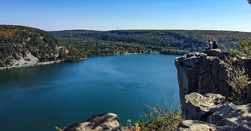
Devil's Lake State Park was recently ranked the #5 best state park in the United States by USA Today. It draws 3 million visitors annually, more than all but the top 4 national parks. There are many things to do at this recreational hub including camping, swimming, boating, scuba diving, rock climbing, and mountain biking ... but hiking is the top activity at Devil's Lake.
Some of the best and most challenging hiking trails in Wisconsin and the Midwest are at Devil's Lake. In the post below you'll find a directory and summary of each trail along with a link to articles with more details and images of the trails. So, let the challenge begin, can you hike all of them?
{tocify} $title={Table of Contents}
$ads={1}
advertisement
Devil's Lake Segment of the Ice Age National Trail
Trail Miles: 10.8 miles linearDifficulty: Difficult

The 1200-mile Ice Age National Scenic Trail crosses through Devils Lake. This challenging trail consists of the Upland, Johnson Moraine, West Bluff, Balanced Rock, East Bluff, and Roznos Meadow Trails. It also connects directly to the Sauk Point and Merrimac Segments of the IAT.
ICE AGE TRAIL - DEVIL'S LAKE SEGMENT - TRAIL MAP AND ARTICLE HERE
East Bluff Trail
Trail Miles: 1.7-Miles linearDifficulty: Moderate-Difficult

Beginning from the North Shore, The East Bluff Trail ascends the east bluff for over a mile on CCC installed stone steps. You'll find many perches for taking in the views along the way as well as features such as Elephant Rock and Elephant Cave. This trail pairs nicely with the Devil's Doorway trail and you can return on the East Bluff Woodlands Trail to create a 4-mile loop. A portion of this trail is also certified as Ice Age National Scenic Trail.
EAST BLUFF - TRAIL MAP AND ARTICLE HERE
West Bluff Trail
Trail Miles: 1.85-Miles linearDifficulty: Difficult
The West Bluff Trail also begins on the North Shore and climbs rapidly on stone steps to the west bluff. The West Bluff trail is a bit more difficult than the East Bluff. You'll find Prospect Point and Cleopatra's Needle on the West Bluff Trail. Returning on the Tumbled Rocks trail creates Devil's Lake's most popular loop route. The West Bluff Trail is certified as Ice Age National Scenic Trail.
WEST BLUFF TRAIL - TRAIL MAP AND ARTICLE HERE
Tumbled Rocks Trail
Trail Miles: 1-mile linearDifficulty: Easy

The easy-going Tumbled Rocks Trail is Devil's Lake's most popular trail. It negotiates a field of large boulders, called a talus slope, along the lakeshore. This trail is paved with asphalt and an easy walk for the whole family. Most hikers begin this trail at the North Shore.
TUMBLED ROCKS TRAIL - TRAIL MAP AND ARTICLE HERE
Balanced Rock Trail
Trail Miles: .4-Miles linearDifficulty: Difficult

Balanced Rock is one of the signature rock features of Devil's Lake State Park. It is accessed via the very challenging Balanced Rock Trail from the South Shore. This short trail is Wisconsin's most difficult hiking climb - a level 4 mountaineering rated climb.
BALANCED ROCK TRAIL - TRAIL MAP AND ARTICLE HERE
Potholes Trail
Trail Miles: .3-Miles linearDifficulty: Difficult

Another difficult climb from the South Shore up the South Face is the highly scenic Potholes Trail. Potholes are glacial rock formations created by swirling eddies of glacial meltwaters. On this trail you'll pass through a tight stone corridor. A suggested route is to climb the Balanced Rock Trail, see Devil's Doorway and descend the Potholes Trail.
POTHOLES TRAIL - TRAIL MAP AND ARTICLE HERE
CCC Trail
Trail Miles: .3-Miles linearDifficulty: Difficult

The third difficult climb on the South Face is the CCC Trail which leads from the CCC parking lot to the East Bluff Trail. This trail is most often used by rock climbers for access to climbing hot spots.
CCC TRAIL - TRAIL MAP AND ARTICLE HERE
Devil's Doorway Trail
Trail Miles: .1-Miles linearDifficulty: Difficult
This short trail ontop the South Face of the East Bluff cuts down to the Devil's Doorway rock formation which is Devil's Lakes most popular scenic feature. The Devil's Doorway Trail is a side trail reached from the East Bluff Trail.
DEVIL'S DOORWAY TRAIL MAP AND ARTICLE HERE
Upland Trail
Trail Miles: 2.8-Miles linearDifficulty: Easy

The Upland Trails is a wide and easy trail that connects the Steinke Basin parking lot to the East Bluff Trail. Use this trail for accessing the East Bluff and Devils' Doorway if you want to avoid the difficult climbs from the South Shore. A portion of the Upland Trail is certified as Ice Age National Scenic Trail. Bikers may also use this trail, and in the winter it is Devil's Lake's best cross-country ski trail.
UPLAND TRAIL - TRAIL MAP AND ARTICLE HERE
East Bluff Woodlands Trail
Trail Miles: 3-Mile networkDifficulty: Moderate-Difficult

The East Bluff Woodlands Trail is a gravel road used for emergency access to the East Bluff trails. It can be hiked as an alternative to the East Bluff Trail and connects via a network of spurs to the East Bluff, Balanced Rock, Devil's Doorway, Upland, and Steinke Basin Trails. If starting this trail from the North Shore the East Bluff Woodlands trail includes a long level 5 mountaineering rated climb to the top of the East Bluff. The East Bluff Woodlands Trail is considered one of the premier cross-country skiing routes at Devil's Lake.
EAST BLUFF WOODLANDS TRAIL MAP AND ARTICLE HERE
Steinke Basin Trail
Trail Miles: 2.4-Mile LoopDifficulty: Easy

The Steinke Basin Loop crosses restored prairie and through woodlands. This easy trail is accessed at a parking lot on County Highway DL. Portions of the Steinke Basin Loop are multi-use and ideal for off-road biking as well as hiking.
STEINKE BASIN TRAIL - TRAIL MAP AND ARTICLE HERE
Johnson Moraine Loop Trail
Trail Miles: 3.5-Mile LoopDifficulty: Easy

The Johnson Moraine Trail connects the Ice Age Campground with the Steinke Basin and Upland Trails. The trail covers gentle terrain on a wide mowed grass trailbed. A 3.5-mile loop can be made by including portions of the Steinke Basin Loop Trail. The Johnson Moraine Trail is certified as a leg of the Ice Age National Tail Devil's Lake Segment.
JOHNSON MORAINE TRAIL - TRAIL MAP AND ARTICLE HERE
Roznos Meadow Trail
Trail Miles: 2.5-Miles linearDifficulty: Easy-Moderate

The Roznos Meadow is a lowland between the South Face of the East Bluff and the South Bluff. The Roznos Meadow Trail begins at a parking lot on Highway 113 and crosses gentle terrain of mixed wetland and restored prairies. After crossing South Lake Drive it ascends to meet the Upland Trail on the South Face. The Roznos Meadow Trail is certified as a leg of the Ice Age National Tail Devil's Lake Segment.
ROZNOS MEADOW TRAIL MAP AND ARTIBLE HERE
Grottos Trail
Trail Miles: .8-Miles linearDifficulty: Very Easy

The gentle Grottos Trail is an easy woodland route that connects trails descending the South Face of the East Bluff to the South Shore lakefront. The Balanced Rock, Potholes, CCC, and Group Camp trails all connect directly to the Grottos Trail.
GROTTOS TRAIL - TRAIL MAP AND ARTICLE HERE
Group Camp Trail
Trail Miles: 1/2-Mile linearDifficulty: Very Easy

The Group Camp Trail is an easy woodlands route that connects the Group Camp parking lot to the Grottos Trail and eventually to the South Shore. The Group Camp Trail can be combined with the Grottos Trail to create a 1-mile easy woodland loop route.
GROUP CAMP TRAIL - TRAIL MAP AND ARTICLE HERE
Ice Age Trail Sauk Point Segment
Trail Miles: 4-Miles linear (8-miles out-and-back)Difficulty: Moderate

The Sauk Point Segment of the Ice Age Trail connects Parfrey's Glen with the Ice Age Trail Devil's Lake Segment. It descends the Baraboo Range 775 feet over two miles when heading towards Parfrey's Glen. On the return trip, this is a level 4 mountaineering rated climb.
ICE AGE TRAIL SAUK POINT SEGMENT - TRAIL MAP AND ARTICLE HERE
Parfrey's Glen Trail
Trail Miles: .85 miles linear (1.7-Miles out-and-back)Difficulty: Easy-to-Difficult

Parfrey's Glen is Wisconsin's first State Natural Area and is part of the Devil's Lake State Park property. The minuscule Parfrey's Glen Stream has cut a deep sandstone canyon to be explored via a short out-and-back trail. The beginning of this trail is easy but becomes more difficult as it progresses back into the stone canyon. Parfrey's Glen can be reached from Devil's Lake via the Sauk Point Segment of the Ice Age Trail or a parking lot on county highway DL.
PARFREY'S GLEN TRAIL MAP AND ARTICLE HERE
Ice Age Trail Merrimac Segment
Trail Miles: 3.6-Miles linearDifficulty: Easy
The Merrimac Segment of the IAT connects directly to the Devil's Lake IAT segment at Roznos Meadow. The Merrimac Segment leads out towards the Merrimac Ferry through the Merrimac Preserve which is adjacent the Devil's Lake State Park property. This trail can be reached from a number of parking lots, but is typically started from the Roznos Meadow parking area.
ICE AGE TRAIL MERRIMAC SEGMENT MAP AND ARTICLE HERE
Griegol Gulch
Trail Miles: 2-Mile lollipopDifficulty: Moderate

Griegol Gulch is a portion of undeveloped parkland in Devil's Lake State Park. You are free to explore the gulch on an unofficial trail that circles through a ravine and crosses a small stream.
GRIEGOL GULCH MAP AND ARTICLE HERE
Devil's Lake Hiking Trail Map
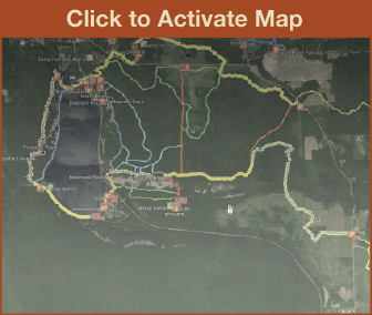
Click Map Image to load the full interactive map.
Address for your GPS: S5975 Park Rd, Baraboo, WI 53913
| coordinates: 43.434496, -89.739531 |
| From Milwaukee | 2 Hours |
| From Madison | 45 minutes |
| From Green Bay | 2.5 Hours |
| From Wausau | 2 Hours |
| From Minneapolis | 3.5 Hours |
| From Chicago | 3 Hours |
Links
Devil's Lake State ParkIce Age National Trail Alliance
Ice Age National Trail - National Parks Service