

|
| Wren Falls |
Following stretches of the Potato River and Tyler Forks Rivers, The North Country Trail (NCT) segment between Foster Falls and Wren Falls is an 8-mile course wrapped in some of Iron County’s most photogenic terrain - river gorges, thundering waterfall, and airy rock outcrops — wrapped on all sides by the Iron County Forest where backpackers can bed down anywhere they like permit-free.
Trail amenities include small gravel parking lots at both ends (Sullivan Fire Road for Foster Falls; Wren Falls Road for Wren Falls), signed blue-blazed singletrack footpaths, short boardwalks and footbridges over wet pockets, and primitive campsites. Camping anywhere in the Iron County Forest (with distance buffers from trails/POIs) is allowed and the trail features four established primitive sites along the route that include tent pads, primitive toilets, access to water, fire rings, and abbreviated picnic tables at sites that are immersed in North Country forests.
When you step off at Foster Falls, you’re walking a corridor shaped by billion-year-old iron-rich bedrock, carved by Ice-Age ice and meltwater, traveled for centuries by Ojibwe, logged and mined in the late 1800s, and now stewarded as part of the Iron County Forest—a public working forest that welcomes backpackers. Listen for thrushes and wrens in the cool bottoms, scan the hemlock crowns for a flicker of glowing Blackburnian orange, and take a quiet moment at the “Gold Mine” site to imagine the boom-time hopes that once rang through this same valley. This is one of my favorite hikes in the state of Wisconsin and I have returned many times for solo overnights and have introduced friends to the pleasures of Wisconsin backpacking on this very trail segment.
{tocify} $title={Table of Contents}
$ads={1}

|
|
Upson Lake Overlook on the NCT |
Route overview (hiking Foster Falls → Wren Falls)
TRAILHEAD AND FIRST MILESStarting from Sullivan Fire Road on the west side of the Potato River. Before you start the hike take time to hop around the rock ledges at Foster Falls—a roughly 25-foot cascade squeezed through sculpted chutes—before churning along the blue-blazed singletrack trail that shadows the river. Expect short footbridges and boardwalks over soggy sections as you leave the falls and angle upstream. This section can be swampy and buggy in summer.
TILTED GABRO CAMPSITE
About a couple miles from Foster, you’ll pass the gorgeous Tilted Gabbro campsite tucked under pines—cozy and scenic. It’s positioned beside riffles on the Potato River. Even though you are just starting out, you might want to throw up a hammock and spend a few lazy hours hanging beside the river here in this idyllic scene. While you're resting here listen for Blackburnian Warbler, look for northern white cedar trees, and scan the river banks for gabro rock formations.
CLIMB TO UPSON LAKE OVERLOOK
Leaving the river you’ll climb onto the Penokee-era rock and hit the Upson Lake Overlook, a bald outcrop with a long view over the lake and forest—one of the route’s signature vistas. Stop and spend some time admiring the birdseye view and take in the breeze. You’ll enjoy a little escape form the bugs up here during summer. From the overlook westbound, the tread rolls across lichen-flecked ledges and mixed woods. You’ll descend slowly into the forest towards the gold mine. Watch for a spur trail down to Upson Lake where there is additional trail access, parking, and nice hiking loop. Upson Lake is an undeveloped lake noted for its rock bass and bluegill fishing.
GOLD MINE
Near mid-segment, look for remnants of an abandoned gold mine (old machinery and water-filled shafts). Stay on the blazed path and keep pets/kids close; some pilot holes are reported to be very deep. The nearby Gold Mine primitive site sits on a small rise about midway on the trail and this site is almost always unclaimed. Remember, primitive sites along this route are first-come-first-serve. Get to a campsite early to claim it, or, since it is legal here, just pop up a tent anywhere along the route 100 feet from the trail or points of interest.
CASEY OVERLOOK
Beyond the mine you’ll pop out at Casey Overlook, a framed window toward the forested hills ahead. As you cross a suspension bridge over a stream feeding the Tyler Forks. Pause here to listen for winter wren. Before too long you’ll be drawn away from the bridge by the sound of Wren Falls nearby.
WREN FALLS
The NCT crosses the Tyler Forks River at the Bill Thomas Bridge, tying into the Wren Falls area, where a large clifftop primitive site and another riverside site sit within a few minutes’ walk. Before reaching the bridge You’ll get outstanding views of Wren Falls, where the Tyler Forks bursts through a pinch in dark rock and drops a dozen feet into a narrow gorge—an ideal bookend for the trip. Parking is nearby at the end of Wren Falls Road which has been improved and is suitable for most vehicles.
Cultural History
BEDROCK AND ICE: HOW THIS LANDSCAPE WAS FORMEDNorthern Iron County lies atop the Penokee–Gogebic Range, a pair of ancient ridges made of some of the oldest rock in Wisconsin. Among them is the Ironwood Iron Formation — striking layers of iron-rich stone formed nearly two billion years ago and later tilted by mountain-building forces. These tough, iron-laden rocks are what create the cliffs and rocky overlooks hikers see today.
Much of the landscape you walk through between Foster Falls and Wren Falls was shaped far more recently by the Wisconsin Glaciation. As the massive Laurentide Ice Sheet advanced and retreated about 25,000 years ago, it carved valleys, filled lowlands with glacial till, and rerouted streams. When the ice melted, it left behind steep ridges of exposed bedrock and broad wetlands where beavers thrive today. The waterfalls along the trail mark spots where hard rock layers force rivers through narrow chutes, creating the dramatic cascades that define this stretch of trail.
Rocks and Minerals of the Penokee Range

Striped iron-rich rocks that define the Penokee Range; these ancient formations date back nearly two billion years.

Durable quartzite ridges underpin many of the region’s scenic overlooks and steep outcrops along the North Country Trail.
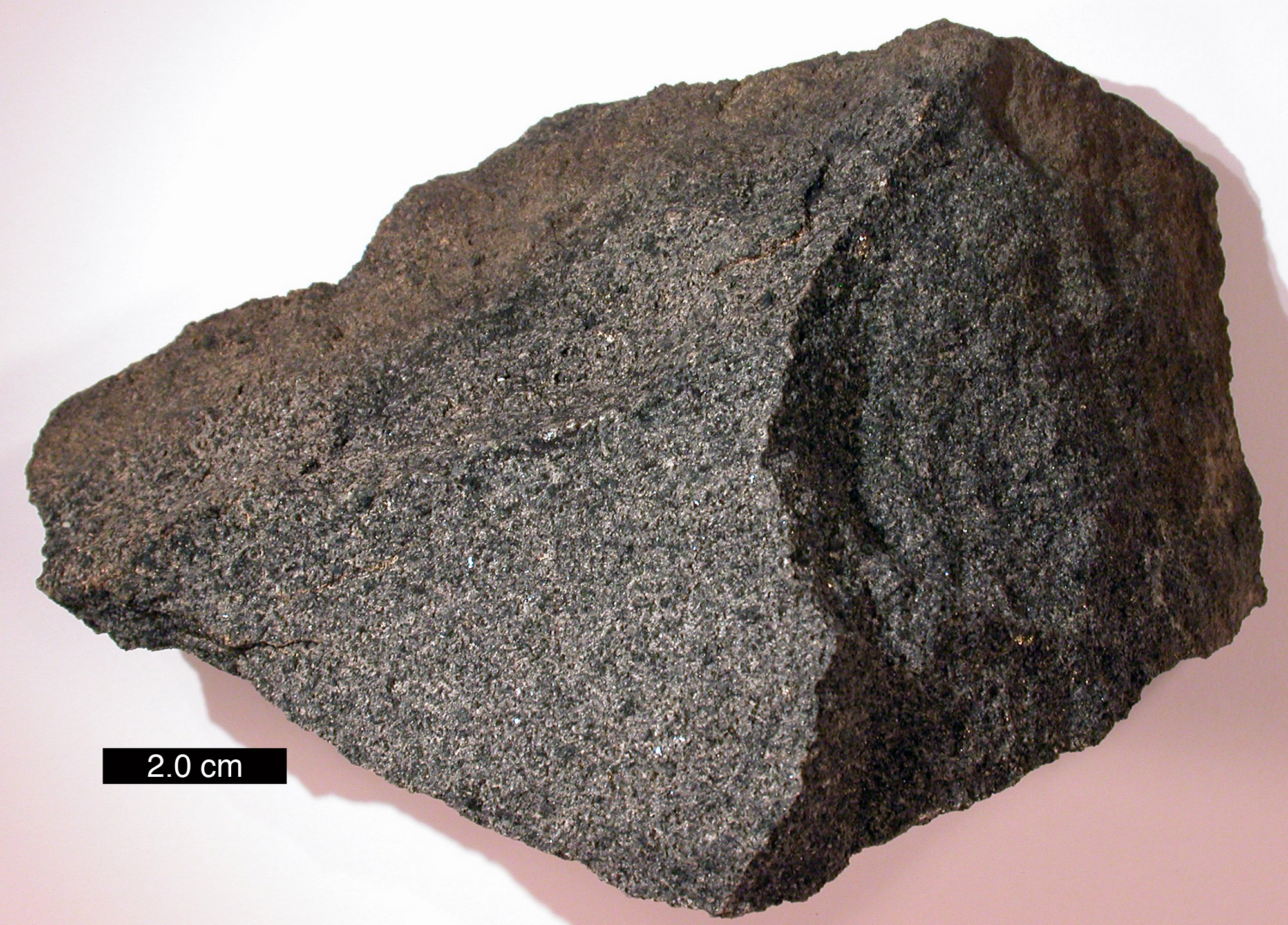
Dark, coarse-grained gabbro forms part of the tilted formations that inspired the name “Tilted Gabbro Campsite.”
SETTLERS, IRON, AND TIMBER
Iron country is part of the homelands of the Anishinaabe/Ojibwe who migrated into Wisconsin from Sault Ste Marie in the 1600’s around the time of European contact and French exploration of northern Wisconsin. After centuries of seasonal movement along water routes for ricing, fishing, hunting, and trade, the 1854 Treaty of La Pointe established the nearby Bad River Reservation; Ojibwe treaty rights for hunting, fishing, and gathering continue across the region’s ceded territory.
Euro-American settlement surged in the 1880s iron boom when the Gogebic (Penokee) Range’s high-grade ores drew investors and workers, and towns such as Hurley blossomed. Mining on the range persisted (with booms and busts) into the mid-20th century. Logging arrived in the same era; when cut-over lands went tax-delinquent, Wisconsin’s County Forest Law enabled counties to assemble large public forests. That program birthed Wisconsin’s county-forest system (first created in 1928), under which Iron County Forest is managed today for timber, water, wildlife, and recreation—exactly the mix hikers experience on the NCT.
A GOLD MINE ON THE TRAIL – WHAT’S THE STORY?
Near mid-segment you pass the NCT’s “Gold Mine” historical site. The Penokee belt is famous for iron, but 19th-century prospectors also poked around for precious metals; historic newspapers mention a “gold rush” that flickered in the 1880s, and several small prospects and shafts were sunk near the Tyler Forks. Today you’ll see relic pits and foundations beside the trail. Use caution and stay back from wells and mine shafts - they're deep and right beside the trail.

|
|
After the Goldmine Campsite you will cross through an old gold mine
where pumps and equipment remain |
THE NORTH COUNTRY TRAIL – AMERICA’S LONGEST FOOTPATH
The establishment of the North Country Trail through the Iron County Forest is yet another chapter in the cultural history of this area, and one we hope will endure for a thousand years. The North Country National Scenic Trail (NCT) stretches nearly 4,800 miles across eight northern states from North Dakota to Vermont. In Wisconsin, the NCT winds through the Northwoods across Iron, Ashland, Bayfield, and Douglas Counties – connecting Michigan’s UP to the Minnesota North Shore.
The trail is built and cared for by local volunteer chapters of the North Country Trail Association. The Heritage Chapter of the NCTA oversees the portions of the NCT in Iron and Ashland counties and was responsible for blazing the Foster Falls to Wren Falls segment in Iron County only a few years ago. This blog post defines this segment between the parking lots at Foster Falls and Wren Falls, but North Country Trail continues north to Gurney and west to Copper Falls State Park. The Heritage Chapter will open more certified trail north to Lake Superior in the coming years, and eventually they’ll connect the trail to NCT segments in Michigan’s Upper Peninsula.

|
|
North Country Trail beside the Potato River |
Local Ecology - Trees, Flora, and Birds
THE FOREST YOU’RE WALKING THROUGHThis corridor is classic northern mesic hardwood with conifer inclusions: sugar maple, yellow birch, paper birch, red maple, basswood on uplands; hemlock, white pine, balsam fir, and white spruce in cooler pockets; and white cedar, tamarack, and black spruce in wet ribbons. Expect blowdown pockets and coarse woody debris in younger stands, and lichen-flecked bedrock near overlooks.
Spring flora (late April–May): On rich maple slopes and moist ravines, look for hepatica, trout-lily, bloodroot, large-flowered trillium, Dutchman’s breeches, bellwort, and wild leek (ramps). These spring ephemerals bloom before the canopy closes, then fade by early summer. Wet spots light up with marsh marigold in late April–May.
Trees and Wildflowers Along the Foster–Wren Falls Trail

The signature hardwood of northern Wisconsin, Sugar Maple dominates upland forests and produces brilliant fall color.

Found in cool, wet ravines and near streams, this aromatic conifer creates dense evergreen groves along the Potato and Tyler Forks Rivers.
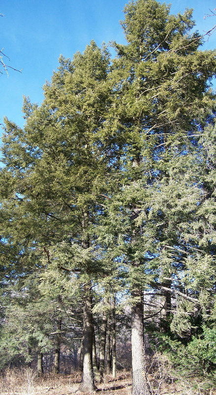
This shade-tolerant conifer thrives on north slopes and cool valleys, lending a deep green tone to the mixed forest canopy.

Appearing in May, trillium carpets rich maple woods with its iconic three-petaled white blossoms.
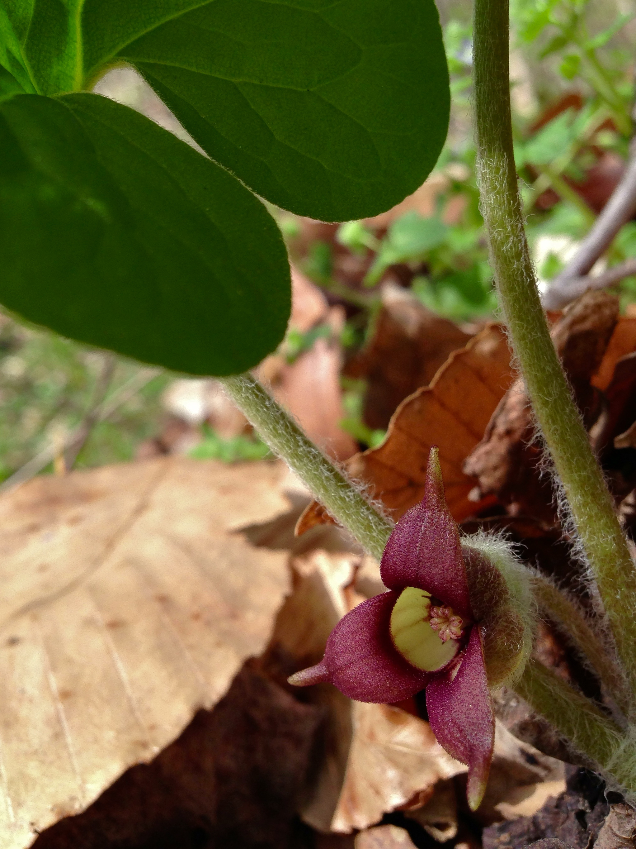
This low-growing groundcover blankets moist soils; its heart-shaped leaves hide small maroon flowers at ground level.

Among the first to bloom each spring, trout-lilies nod beneath sugar maples on sun-dappled slopes.
WHAT YOU MIGHT HEAR: A BIRDER’S GUIDE FOR THE TRAIL
Summer–fall notes: Canopy birdsong stays lively into June as warblers finish nesting high in mixed hardwood–conifer stands; by September, maples and birches start turning, and the understory opens for easier views into the Potato River and Tyler Forks corridors.
This stretch is superb for sound-first birding. Three voices to learn:
Hermit Thrush (Catharus guttatus) — Ethereal, flute-like phrases that rise and spiral from shaded midstory perches in May–June. If there’s one sound that means North Woods, it’s this.
Winter Wren (Troglodytes hiemalis) — A tiny bird with a huge, cascading, bell-like song pouring from blowdowns and cedar-spruce tangles along creeks.
Blackburnian Warbler (Setophaga fusca) — High canopy specialist; listen for the buzzy, sibilant trill that ascends to a glass-shattering final note near hemlock–pine crowns.
Birds of the Foster–Wren Segment (North Country Trail)
Hear three classic voices of the North Woods. Tap play to sample each species’ typical call/song.

.jpg)
_male_San_Isidro.jpg)
North Country National Trail - Wren Falls to Foster Falls Section
COUNTY
IRON
COMMUNITIES
ANDERSON, GURNEY, UPSON
TOTAL MILES
8-MILES POINT-TO-POINT
DIFFICULTY
MODERATE
LOWEST ELEVATION
1241 AMSL BILL THOMAS BRIDGE
HIGHEST ELEVATION
1607 AMSL UPSON LAKE OVERLOOK
CUMULATIVE ELEVATION GAIN
1272
CUMULATIVE ELEVATION LOST
-1299
NEXT NCT SEGMENT EASTBOUND
GURNERY TO FOSTER FALLS SEGMENT
NEXT NCT SEGMENT WESTBOUND
PORCUPINE HILL SEGMENT
POINTS OF INTEREST
Wren Falls, Foster Falls, Casey Overlook, Upson Lake Overlook, Gold Mine, Tyler Forks River, Potato River, Upson Lake, Iron County Forest
CAMPING
This trail is entirely within the Iron County Forest and permit and fee free primitive camping is allowed anywhere along its length 100 feet from a trail or point-of-interest. Established Primitive Sites at Wren Falls, Tyler Forks, Gold Mine, Tilted Gabbro, and Foster Falls.
A two-way from–to mileage matrix for the North Country Trail segment between Foster Falls and Wren Falls in Iron County, Wisconsin. Points of interest are labeled on both the top row and the left column. Cells show one-way trail miles in either direction. Diagonal cells show an em dash to indicate zero distance (same location).
| From ↓ / To → | Foster Falls | Tilted Gabbro Camp | Upson Over Look | Gold Mine | Gold Mine Camp | Casey Over Look | Wren Falls |
|---|---|---|---|---|---|---|---|
| Foster Falls | — | 1.6 | 2.8 | 4.2 | 4.6 | 5.0 | 8.0 |
| Tilted Gabbro Campsite | 1.6 | — | 1.2 | 2.6 | 3.0 | 3.4 | 6.4 |
| Upson Overlook | 2.8 | 1.2 | — | 1.4 | 1.8 | 2.2 | 5.2 |
| Gold Mine | 4.2 | 2.6 | 1.4 | — | 0.4 | 0.8 | 3.8 |
| Gold Mine Campsite | 4.6 | 3.0 | 1.8 | 0.4 | — | 0.4 | 3.4 |
| Casey Overlook | 5.0 | 3.4 | 2.2 | 0.8 | 0.4 | — | 3.0 |
| Wren Falls | 8.0 | 6.4 | 5.2 | 3.8 | 3.4 | 3.0 | — |
Directions and Trail Map
WREN FALLS TO FOSTER FALLS BROCHURE AND OFFICIAL MAPGEOREFERENCED PDF MAP
The Georeferenced Map in the link above can be printed on standar letter size paper, or be added to an offline mapping app such as Avenza or Caltopo so you can follow along the route with GPS.
DIRECTIONS: Turn onto Vogues Road off Highway 169. Follow Vogues Road to an intersection with Casey Sag Road and Wren Falls Road. Take Wren Falls Road to Wren Falls Parking Lot. To get to Foster Falls, continue from Vogues Road at the hairpin turn onto Casey Sag Road and after a mile veer to the left onto to Sullivan Fire Road. Take the fire road and 300 feet before the Potato River there is parking to the left.
Beware that GPS may try to route you to Foster Falls on Sullivan Road from Highway 122 ... that will put you on the east side of the river, across the river from the trail.
| Wren Falls Coordinates: 46.399116, -90.504839 |
| Foster Falls Coordinates: 46.421030, -90.460527|
| From Milwaukee | 5 Hours |
| From Madison | 4.5 Hours |
| From Green Bay | 4 Hours |
| From Wausau | 2.5 Hours |
| From Minneapolis | 4 Hours |
| From Chicago | 6.5 Hours |
Photos

|
|
The Bill Thomas Bridge crosses the Tyler Forks at Wren Falls and
connects to an area of trail that is being constructed in 2020-2021 |

|
|
A large campsite at Wren Falls has space for many tents and has a fire
ring and latrine. It is a close walk to the parking area. |

|
| Looking across Tyler Forks at the Wren Falls Campsite that sits on top of a steep stone cliff |

|
| At Wren Falls the Tyler Forks River is very scenic |


|
|
Just across the Bill Thomas Bridge a new primitive campsite is being
built |

|
|
The new primitive campsite at Wren Falls is on a river bank above the
Tyler Forks. Looks like good fishing. |

|
|
Looking back from Wren Falls at the new Bill Thomas Bridge |

|
| Starting down the trail towards Foster Falls, you won't have to worry about wet feet, There are brides across every stream. |

|
|
A short section of two track troad leads away from Wren Falls |

|
| After passing a wetland look for the trail to go off the road on to single track footpath |

|
| The trail climbs a couple of steep hills to start off. One of the hill climbs pays off with a rest at Casey Overlook |

|
|
Be aware of pilot holes and mine shafts at the gold mine. The holes
are filled with water, but are 100 feet deep |

|
|
A long section of climbs pays off at the Upson Lake Overlook |

|
| More well constructed bridges on the NCT cross frequently over soggy terrain beside the Potato River |

|
| Tilted Gabbro campsite is a picturesque campsite, but small |

|
|
There are a few tent pads, Tilted Gabbro can support 4-6 small tents.
Large groups should continue on to the Foster Falls site. |

|
|
Tent pad at Tilted Gabbro Campsite |

|
| Tent pad at Tilted Gabbro Campsite |

|
| Tilted Gabbro Site has a couple benches, table, and fire circle set close to the Potato River |

|
| Tilted Gabbro Campsite |

|
| Latrines are located at the Wren Falls, Foster Falls, Gold Mine, and Tilted Gabbro sites |

|
| Morning Campfire before departing Tilted Gabbro |

|
|
Boardwalk after Tilted Gabbro |

|
|
Foster Falls is a large rock outcropping in the Potato River with
several water chutes |

|
| Foster Falls |

|
| Foster Falls |

|
|
A very large primitive group campsite is available on the East bank of
the Potato River at Foster Falls |