

Harrison hills is among the most epic and memorable segments of the Ice Age Trail. It is a difficult 14.4-miles that connects between the Alta Junction Segment at its west trailhead and the Parish Hills Segment to the east. The entire length of this trail cuts through the Lincoln County Forest and primitive camping is allowed along its entire distance. This trail is a roller coaster that meanders uphill to a ‘summit’ at Lookout Mountain near the center of the segment.
Unfortunately, the most distinguishing feature of this segment is the noise of passing and more distant ATV’s. You will not find peace along this trail between Bus Lake and the eastern trailhead at Fish Lake Road.
{tocify} $title={Table of Contents}
$ads={1}
advertisement
My legs yearned for a stretch after being dormant over the winter months. Then on the 1st of May in 2021 we were given the gift of a Saturday forecast to be in the 80’s. I would be joined by nearly every other Wisconsinite in heading for the outdoors. It would soon become apparent that I had gotten myself in to more than I bargained for.
I had decided last minute to take advantage of the fine weather and spend the day and evening backpacking and camping along a trail. But I’d need to find a trail that was easy to get to and get myself going right away. I had previously earmarked Harrison Hills as an ideal place for a last-minute backpacking trip. Its trailhead is only a few minutes east of Hwy 51 and can be reached from Southern Wisconsin within a couple hours of easy freeway driving. I figured that I could start at the west end of the trail and hike about 12-miles to the Chain Lakes where the map shows two primitive campsites, and if I had competition for those sites, I knew that I could camp pretty much anywhere along this trail where I could find a suitable clear space.
Oftentimes plans look better on a map then they turn out to be in reality. So, I’ll spare you a drawn-out story and just explain what went wrong with my trip. I had spent my time the previous winter binge watching streaming TV and was badly out of shape at the beginning of this season. Twenty-four miles in 24-hours of backpacking on hilly terrain would have been challenging but par for me in the previous Fall. But after loafing around for too long this hike was on the upper end of what I could handle. The forecast for the unseasonably hot day, which I had perceived as a gift, ended up being too much of a good thing. Way. Way too hot for a man who had just gotten used to scraping snow off my windshield without a jacket or gloves. even in July an 80-degree day makes a nap in air conditioning more enticing than a backpacking trip. Let’s just say i’m a bit like Goldilocks when it comes to backpacking. I sweated, sweltered, and withered the entire way. I’d have traded that early May heat for 70’s with black flies and mosquitoes … wait. No, I wouldn’t.
The worst part about this trip is what you can never see by looking at a map. According to the maps and the satellite views this looks like an ideal back-country type hiking paradise. The trail appeared to be covered by dense forest, to be mildly hilly, with a few healthy and challenging climbs, and to have many scenic lakes and overlooks. And yes, this is all true. There are many scenic lakes and overlooks. This trail would be shade covered during the late spring, summer, and fall but the leaves had not yet popped. There was no escape from that now-90-degree sun. Standing beside these scenic lakes would have been rewarding if there was any peace along this trail. But what is not apparent from the hiking trail maps is that the Harrison Hills of the Lincoln County Forest is a very popular ATV park.
No disrespect to the ATV crowd, it seems like it could be fun riding at 15 mph in a line of tricked out golf carts. Sure. Seems like something i’ll look forward to when I’m retired. But while I can still carry a backpack, I am a hiker, and hiking is about riding in a car for a bunch of hours, away from all the other cars, so I can get out of that car and not into another one.
I am glad that Lincoln County has made room for the Ice Age Trail to pass through its forests just as it has accommodated other sports including mountain biking, horseback riding, and ATV’ing. But if you are reading this article as a guide and in search of excellent hiking trails let it be understood now that the ATV traffic is constant and louder than the city you’re trying to escape from. There is only a short portion at the west end of this trail where the ATV traffic is more distant. More often, the Harrison Hills Segment follows right beside ATV trails.
Now that I’ve confessed that my first backpacking trip of the year turned out to be a dud, I will put that all aside and share with you the things that I’ve learned about this trail.
Getting to this trail and getting parked is easy. The parking lot at Alta Junction is a bit hard to spot and there is only room for a few vehicles and not much room for turning around. The other parking lot at Turtle Lake Road is a few miles down a gravel county forest roadbed. Don’t worry about the conditions of this road. It is wide and well maintained and any vehicle will be able to navigate it. The parking lot off this road is flat and grass covered and large enough to hold ten vehicles. The other lots, one at the center of this segment, and one at the east trailhead are even larger and easier to access than these.
After parking at Alta Junction, I felt great slipping my backpack on and heading off into the woods. The first section of this hike to Bus Lake is mild and easy hiking. There are many picturesque wetland overlooks. The trail is single track and on firm dry ground. The first big climb takes you to an overlook of Bus Lake.
I could see down to the campsite on the far side of bus lake and was not surprised to spy a couple of RV’s and a large group tossing corn hole. On a quiet weekday you might find this glorious site available for you to camp at free of charge. It is a single isolated drive-in site with a ton of space and a huge fire ring right beside the Lakeshore. There is a marked side trail leading between the site and the overlook on the Ice Age Trail.
From the overlook at Bus Lake the Ice Age Trail descends the hill into a dense pine forest. From there it is not too long before you reach another scenic lake. A new primitive campsite has been established on a small rise overlooking this lake. There is room for as many as four small tents and a small fire ring. Had I been more realistic in my expectations for my hike I would have claimed this empty site and would have had quite a comfortable evening here before heading back to my car the next morning. But I pushed onward.
From the small scenic unnamed lake, the trail becomes much more hilly as it begins to ascend to Lookout Mountain. This is also where you will encounter the ATV trails for the first time. There are many short and very steep climbs that roll back down in elevation only to climb higher and steeper over the next hill. If a workout is what you are looking for you will find it here on Harrison Hills.
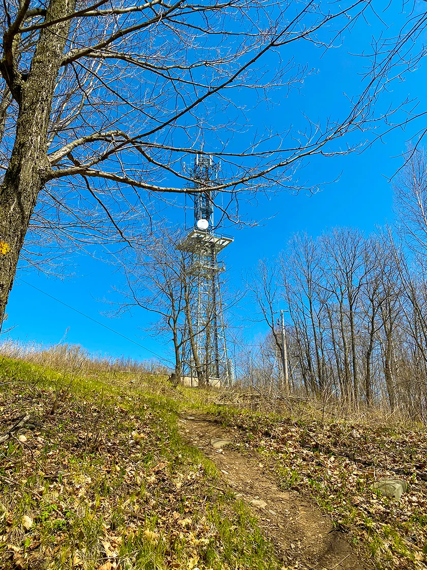
I found the climb to Lookout Mountain to be strenuous with a fully loaded backpack but when I arrived at the radio tower, I still had plenty of energy left. For being the summit of this trail, it is disappointing that there is not a scenic overlook. But I was glad to find space to sit down and enjoy my lunch.
Continuing eastbound the trail descends Lookout Mountain more casually through a beautiful hardwood forest. The trail joins the access road for Lookout Mountain and descends steeply before turning back off on a single-track hiking trail. You’ll encounter a few smaller hills before reaching the ATV parking lot.
By the time I reached the ATV parking lot my energy was tanked, and I still had two miles to hike before reaching the Chain Lakes where I was promised a pair of campsites. I had hopes that the terrain would be milder in this last two miles, but it did not come to be. The overall elevation is descending but there are several steep rocky hill climbs punctuating this route. My enjoyment of this hike began to diminish with each step.
My energy was so sapped during this last two miles that I was stopping to take breaks nearly every 20 steps. But my mood was uplifted a bit when I came to the stream that leads to the Chain Lakes. The trail follows along this stream and at leads through exactly the type of scenery I had expected, a beautiful back country fishing lake. Yet it was apparent that there are highly trafficked ATV trails ringing around this lake.
I crossed my fingers as I entered the lake area and hoped for an available campsite. But I was not so lucky. The first campsite was filled with a talkative crowd. Had I arrived in better shape I might have asked the group if they could make room for me within their site. I hiked to the second site along this trail and found a couple of tents that had been set up, so I turned around and bushwhacked to the far side of the lake where I found a stream teeming with fish and a suitable site to set up a single tent in thick weeds.
I have never before attempted to set up a campsite in such an exhausted state. Each small task required mental coaching. Setting up a simple gravity filter for water was a tiring ordeal. Yet bit by bit things started to take shape. I had no energy to search for firewood or build a fire ring. So, I tuned my weather radio into the Brewers baseball game and laid back in my tent and listened for the next five hours and 11 innings. After satisfying myself of a Brewers win over the Dodgers I slept fast and hard.
The next morning I woke and was packed up before the sun rose. I knew what was in store for me And I loathed the 12-mile rigorous hike in front of me. But I had gathered some energy after resting for the evening. The climb to Lookout Mountain in reverse was much easier than the hike from west to east the day before. But the repeated roller coaster of hill climbs after the summit destroyed what was left of my energy. When I arrived back at my car I popped the back hatch, let my backpack fall into the trunk of my car and then I climbed in with it and kicked back for a long rest before I could contemplate changing clothes and driving home.
I know that I would fare much better if I had attempted this trail further into the season when I was in better shape and when the weather was cooler. But I am glad this segment of the Ice Age Trail is behind me, and I will not seek to rehike it in the future.

|
| A stream leads away from the Chain Lakes where there are two primitive campsites |
Ice Age Trail Harrison Hills Segment
COUNTY
LINCOLN
COMMUNITIES
GLEASON, PARRISH
TOTAL MILES
14.5-MILE POINT TO POINT
DIFFICULTY
DIFFICULT
LOWEST ELEVATION
1447 AMSL
HIGHEST ELEVATION
1942 AMSL
TOTAL ELEVATION GAIN
2600 FT
NEXT IAT SEGMENT EASTBOUND
PARRISH HILLS SEGMENT
NEXT IAT SEGMENT WESTBOUND
ALTA JUNCTION SEGMENT
CAMPING
Sites at Bus Lake, Unnamed Lake, 2 sites at Chain Lakes
Directions and Trail Map

Click Map Image to load the full interactive map.
If viewing on a mobile device, open the trail map above to load into Google Maps App by touching the expand rectangle in the upper right corner.
Address for your GPS: County Rd B, Gleason WI 54435
| coordinates: 45.410361, -89.462712 |
| From Milwaukee | 3.5 Hours |
| From Madison | 3 Hours |
| From Green Bay | 2 Hours |
| From Wausau | 1 Hours |
| From Minneapolis | 3.5 Hours |
| From Chicago | 5.5 Hours |
Photos

|
| Even smaller hills are steep and difficult on this sement |

|
| There is a side trail to Bus Lake Campsite |

|
| The Bus Lake overlook is a welcome rest after a long hill climb |

|
| The path cuts through dense pines to another unnamed lake after Bus Lake |

|
| At the next lake after Bus Lake there is a newly established campsite with a fire ring. This site is not yet shown on maps. |

|
| Small scenic lakes and wetlands are nearly always in view on this trail |

|
| A stream flows out of the unnamed lake, a good source for drinking water |

|
| Along the Harrison Hills Segment in Lincoln County WI |

|
| The hills become more serious in the long approach to Lookout Mountain |

|
| You've already gained elevation and the climbs become ever steeper in the approach to Lookout Mountain. |

|
| There are long lengths of rolling hills in the final approach to Lookout Mountain |
|
| At last you arrive at the radio tower at Lookout Mountain |

|
| Lookout Mountain is the official name of this hill, as indicated on the survey marker |

|
| Milder terrain on the east side of Lookout Mountain |

|
| Views on the east side of Lookout Mountain are still long |

|
| The Parking lot at the ATV Parking Area |