
The Parrish Hills Segment of the Ice Age National Scenic Trail connects between the Harrison Hills Segment headed westbound and the Highland Lakes East Segment headed eastbound. This 11.6-mile segment is rated as difficult with rugged terrain, a ford of the Prairie River, and many hills to climb and descend.
Most of the miles of the Parish Hills segment are blazed through the Langlade County Forest where primitive camping is allowed.
{tocify} $title={Table of Contents}
$ads={1}
advertisement
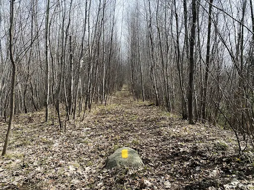
For most hikers, crossing of the Prairie River will stand out as the most memorable moment of this trail, but for me what I recall most are the troads … two track logging roads winding through the Langlade County Forest.
I was lucky to have a hiking partner along with me for the segment. We parked a car at Townline Lake parking lot at the east trailhead, then shuttled over to Parrish and parked at the Prairie River State Fishery Area.
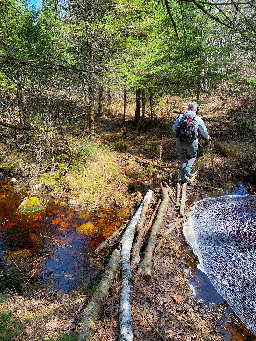
Our first obstacle of the day was fording the Prairie River. The river is wide and there are riffles in the area at the ford. I had brought a pair of lightweight old shoes that I swapped into just for this crossing. The crossing was never deeper than knee height and the current was noticeable but not overwhelming. Once across, I changed back into my primary hiking shoes which was premature because there are mud pits and puddles in the wetlands beside the river for a way before the trail elevates and dries out.
When fording any river, it is helpful to wear shoes to prevent yourself from snagging on fishhooks or sharp rocks unseen in the water. Another piece of essential equipment are trekking poles for stability. Unclip your backpack straps in case you tumble into the river so that you can quickly release your backpack. Keep your head up and focus on the points on the opposite riverbank that you are headed towards as looking down at the rushing water can make you dizzy and lose track of where you are in the crossing.
As many as half the miles of this trail follow logging roads or ATV trails. We were able to hike side-by-side and have a good conversation along the way which made the frequent small hills less noticeable.
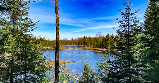
There were a few scenic sections of the trail where it tightened to a single track through dense pines and overlooks of wetlands.
I recall a few minor stream crossings that were either rock-hops or short balances on logs. For the most part we were able to keep our feet dry the entire way.
CAMPING ALONG PARRISH HILLS SEGMENT
Primitive camping is allowed on the segments in the Langlade County Forest which is the area between the Prairie River and Townline Lake. There were three spots that I noticed along our hike that would be ideal for camping. The first was along an ATV trail where there is an old picnic shelter and a pair of crumbling latrines where there is wide open ground to set up tents. Another area of open ground and a small fire circle can be found where the trail emerges at Five Cent Road. Keep in mind that you are not permitted to camp in the vicinity of the ATV shelter north of Five Cent Road. The trail doesn’t go in this direction so you shouldn’t even be tempted, however I would note that the restroom and water facilities at the ATV trail shelter are available for hikers to use.
There’s a small pond just west of the Nelson Fire Lane where the trail crosses beneath dense pines and I found a nice flat area where a couple hikers could setup tents with views of the scenic pond, and the pond as a source to filter water from.
The area around Townline Lake is the most scenic part of the trail. It is also the end of the trail and sadly there is no camping allowed around the shores of this lake.

|
| The foot crossing (river ford) at the Prairie River in Parrish |
Ice Age Trail Parrish Hills Segment
COUNTY
LINCOLN, LANGLADE
COMMUNITIES
PARRISH, UPHAM, SUMMIT LAKE
TOTAL MILES
11.5-MILES POINT TO POINT
DIFFICULTY
DIFFICULT
LOWEST ELEVATION
1600 AMSL
HIGHEST ELEVATION
1870 AMSL
TOTAL ELEVATION GAIN
2025 FT
NEXT IAT SEGMENT EASTBOUND
HIGHLAND LAKES WEST SEGMENT
NEXT IAT SEGMENT WESTBOUND
HARRISON HILLS SEGMENT
CAMPING
Anywhere in the Langlade County Forest 50' from trail and water. Potential site at unnamed pond. No camping allowed near ATV Cabin off 5 Cent RD.
Directions and Trail Map

Click Map Image to load the full interactive map.
If viewing on a mobile device, open the trail map above to load into Google Maps App by touching the expand rectangle in the upper right corner.
Address for your GPS: 14700 Pine Drive, Gleason, WI 54435
| coordinates: 45.423117, -89.392340 |
| From Milwaukee | 3.5 Hours |
| From Madison | 3 Hours |
| From Green Bay | 2 Hours |
| From Wausau | 1 Hour |
| From Minneapolis | 3.5 Hours |
| From Chicago | 5.5 Hours |
Photos

|
| After crossing the Prairie River there are muckey areas before the trail gains height |

|
| Another view of the wet areas on the trail beside the Prairie River |

|
| As the trail climbs in elevation it passes through the Prairie River State Fishery Area |

|
| The trail mostly follows two track roads (troads) |

|
| There is an old picnic area after the trail crosses an ATV trail. this area has space to setup a couple of tents |

|
| The IAT picks up in the woods after the picnic shelter |

|
| The trail crosses through several recently logged out areas that are beginning to regenerate |

|
| water traps continue to be a problem along this trail |

|
| In some place along the Parrish Hills Segment there are views of wetlands and small lakes |
|
| There are a few stream crossings that are easy to get across on the Parrish Hills Segment |

|
| Logging is active in the Langlade County Forest |

|
| The trail approaches a pond |

|
| There is a nice area for a campsite beside the pond |
|
| Along the Ice Age Trail Parrish Hills Segment |

|
| More water traps on the east end of this segment |

|
| The picnic area at Townline Lake at the east trailhead for the Parrish Hills Segment |

|
| The east trailhead for the Parrish Hills Segment |