

Bayfield County may be better known for its charming lakeside villages, but it is also a destination for adventurers seeking endless forest and small Wisconsin lakes in the Washburn District of The Chequamegon National Forest. Wisconsin’s woods may be at their deepest in the area surrounding Drummond. The North Country National Scenic Trail cuts through these woods. The trail provides for exceptional hiking and backpacking, passing several primitive campsites and bisecting the Rainbow Lake Federal Wilderness. In fact, I’m so in love with all that Bayfield County offers (especially its trails!) that this is now the first place I think of when I want a quick getaway either with friends or as a solo traveler.
The backpacking route I’ll describe in this article is 12.5-miles of moderately difficult trail between the north tailhead of the NCT in the Rainbow Lake Wilderness and the Drummond Woods Trailhead at Highway 63. This is it. This is the one. When I think Wisconsin backpacking this is the trail I think of.
{tocify} $title={Table of Contents}
$ads={1}
advertisement
HIKING THE RAINBOW LAKE WILDERNESS ON THE NORTH COUNTRY TRAIL
I was mindlessly chasing ice cubes around a brandy old fashioned and kicked back in a comfy rocking chair on the deck of a hotel room in Duluth. My late-night view across Lake Superior was focused off into the distance on a violently strobing late summer lightning storm barreling across Lake Superior from the Minnesota North Shore to Wisconsin’s Apostle Islands. The storms of 2021 had been as ferocious as they were frequent and had left deadfall scattered over the trails of Wisconsin’s Northwoods to prove it. Having already experienced camping in these storms several times this season I didn’t mind skipping this day of backpacking and postponing my first trip into the Rainbow Lake Wilderness. Before dawn the next morning I was skimming down wet highways towards Delta WI.
I never know quite what to expect with forest roads but was aiming for a parking lot on West Delta Road (FR 228). I’ve been caught driving down potholed dirt forest roads with deep waterfilled ruts and tree branches scrapping the sides of my car before; and by the time I might decide to turn around there’s no way to turn around. With the previous night’s storms there could be fallen trees or washouts blocking the way. I was relieved to find Bayfield County’s gravel roads wide and firmly graded with crushed red stone. The parking lot is a grassy flat cut beside the road that can hold three cars. Across from the lot is the trailhead for the North Country Trail marked by the familiar badge of the Forest Service’s wilderness signs.
A federal wilderness is a special designation within a national forest. This is land that will be left to just be, spared the chainsaw. Wildernesses are non-motorized, meaning ATV’s won’t bust the sound of songbirds or the pitter patter dripping of the woods the day after a rainstorm. And you can camp anywhere here, fee and permit free.
The Rainbow Lake Wilderness is an example of a forest that in 2021 is just a decade or so out from reaching the status of old growth forest. Measured in years, an old growth hardwood forest must be at least 150 years old, and this area was last clear cut in the 1890’s. But even if these woods are not quite fully mature, you’ll still find the distinguishing features of a virgin forest in the making. There is a mix of tree ages with a few massive white pines scattered among younger birch and middle-aged maples. There are plenty of standing snags, those dead trees that are perforated with woodpecker holes. You’ll find random openings in the woods where a large tree was felled by wind long ago. And the most telltale sign of all are the pit and mounds across the terrain. The pits are caused by a fallen tree being uprooted, and next to the pit will be a mound where the tree roots decayed into a pile of rich and soft dirt along with the stones that had been caught and uplifted with the roots and eventually dropped into a pile.
From the north trailhead of the Rainbow Lake Wilderness the North Country Trail is a narrow trail that is barely visible at times as it cuts through a young hardwood forest with a soft green grass forest floor. The trail passes beside some deep kettles and there are a few climbs in this glacial moraine topography. You’ll pass the site of an old radio tower, or perhaps it was a fire tower. I found no evidence of the tower nor the old tower trail which older maps describe. I did spot a grown over old road heading west from the NCT, but nothing heading east to the old tower trail trailhead.
At about 2-miles in you’ll reach Tower Lake where there is a small primitive campsite established directly beside the trail. This small site has a nice view of the lake, a fire circle, a few logs to rest your head against while sprawled out next to the fire and space for 2-3 tents.
The trail is a bit more hilly and windy as it approaches Rainbow Lake another mile to the south. There’s a very flat campsite here on the edge of Rainbow Lake, but it is surrounded by thick vegetation and no clear lake view despite being at the lake edge. Rainbow Lake has a mucky shoreline, and it is hard to get to, but the beavers and the wolves seem to like this lake nonetheless. Sleep may come hard with the overnight howling of the wolves.
ANDERSON GRADE TRAIL

|
| Along the Anderson Grade Trail in Fall |
There’s a few more hills south of Rainbow Lake, but the trail picks up along an old railroad grade and it stays very straight and flat for a distance. Roughly 2-miles south of Rainbow Lake you’ll cross the Anderson Grade Trail at Bufo Lake.
I had hiked the length of the Anderson Grade on a separate trip later that fall and this is another trail I rate highly. It gets less than stellar reviews on hiking apps and I’m not sure why others have dismissed it. It is a flat and straight trail which also follows an old railroad grade. Anderson Grade bisects the Rainbow Lakes Wilderness from east to west passing four beautiful fishing lakes and a few wetlands including a tamarack swamp along the way. The trail is dry most of the way other than one brief shallow stream that flows across the trail from Flakefjord Lake to Clay Lake.
The Anderson Grade is 4-miles in total length and very easy to walk. Its east trailhead is at the Perch Lake drive-in campground where I camped on one of my trips to this area. It’s 2-miles from Perch Lake to reach the intersection with the North Country Trail. And from that intersection another 1-mile to Anderson Lake where there is small but extraordinary campsite on the northwestern shore.
I searched all around Bufo Lake to find a campsite and did not find a fire ring. There is a trail to reach the peninsula striking off from the Anderson Grade and another trail to the lakeshore from the NCT. At the shore at the end of the side trail from the NCT there is flat ground elevated a few feet above Bufo Lake that would make for a good campsite, all it needs a fire ring to be built.
SOUTH OF ANDERSON GRADE
Heading south along the North Country Trail from Anderson Grade the trail is straight, wide, and flat. The next lake you’ll get to is Reynard Lake where there is a massive primitive campsite just off the trail on the north end of the lake. This site is remarkably flat and sheltered beneath pine trees that create framed views of the lake. This is such a picture-perfect campsite that you’ll be lucky to be the first to claim it. Make sure you arrive early in the day if it is your plan to camp here.
There’s a short boardwalk crossing a stream on the south end of the lake and a side trail with a canoe put-in on Wishbone Lake. It’s only a few steps from Wishbone Lake to reach Reynard Lake Road which is the southern border of the Rainbow Lake Wilderness.
SOUTH OF RAINBOW LAKE WILDERNESS

|
| Old growth white pines tower above the North Country Trail at Drummond Woods |
The North Country Trail continues its course out of the wilderness and through the Chequamegon National Forest. It’s two miles from Reynard Lake Road to Delta-Drummond Road where there is a paved parking lot.
After crossing Delta-Drummond Road the trail becomes hillier, so prepare for a workout. You’ll find a small campsite directly beside Mirror Lake just off the trail about a 45-minute hike in from Delta-Drummond Road. There are quite a few dead branches hanging over the site, so I bypassed this one even though I was ready to be finished hiking.
Esox Lake is surrounded by steeply sloping hills. I am told there is campsite on this lake as well, but I can’t imagine where it is as this area is quite hilly. I saw an old rowboat on the shore on the southeast shore midway between the NCT and Esox Road and that is likely the site, but I did not discover a side trail over to it.
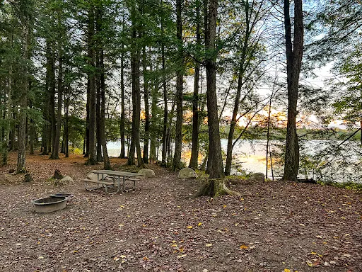
After crossing Cisco Lake Road there is a section of hills and a long descent into the Long Lake Branch Creek valley. Long Lake Branch Creek is an adorable winding creek that can be full and rushing at times or shallow and moving at other times. There is a heavy timber bridge crossing the stream and on the south side of the bridge you’ll find an excellent campsite. This is the site I camped at.
The campsite at Long Lake Branch Creek is in an idyllic valley covered with ferns and soft earth. I very much enjoyed this spot and cooled my aching feet in the creek which was also a cold source for drinking water. True to form, my blue-sky day ended with a torrential downpour and thunderstorm that had me pinned down in my tent for a couple hours in the early evening. But the rain finished before dark, and I was able to enjoy a nice campfire. I was especially thankful for carrying the weight of my mini camp chair which I was able to lounge in beside the fire on that wet evening. As a side note, backpack camping in a severe thunderstorm is both dangerous and fairly scary. How lucky do you feel that lightning will not strike nearby, or a tree will not tumble down on top of you? There’s really no advice once it has already started; just be in a lower area and hope for the best. Though I will say that if I heard the wail of a tornado siren in Drummond, I would have been hiding under the heavy timber bridge and hoping that the creek didn’t flash flood.
From Long Lake Branch Creek there is a long climb up to Sawmill Lane and the trail is somewhat calm and easy the rest of the way to Drummond Woods.
Drummond Woods is a very small area right beside Highway 63 where there are a dozen old growth white pines that are estimated to be 300-400 years old. There are a few ski and interpretative trails that link up with the NCT at Drummond Woods and one of the trails heads directly into town. In Drummond there is a nice little RV campground beside Drummond Lake and there are modern hot showers there. Drummond also has a couple of bars and a convenience store. If you are hiking the distance on the NCT it might be worth the 1-mile walk for an overnight in town.
BAYFIELD COUNTY – AN IDEAL LOCATION TO GET AWAY FROM IT ALL
So, I’ll leave you with this last thought. It’s a long five-hour drive to reach Bayfield County from the southern end of Wisconsin, but it’s worth it. It’s relaxed, quiet, and away from it all while being close to a lot. The variety of options for a vacation seem endless. Let me break it down for you.
Let’s start with the Apostle Islands and Bayfield itself. If you want that nautical seaside weekend or a dose of laid-back island culture you can’t do much better than Bayfield and Madeline Island. Then there is the phenomenally scenic trail at Meyers Beach over to views of the sea caves with a trail that terminates 5-miles in at a reservable campsite on a Lake Superior Beach. Think private beach to yourself for 20-miles in each direction.
If camping is your thing, then you’ll have options for RV camping, and a few super scenic drive-in national forest campgrounds. Can’t find a drive-in site? No problem. There are primitive sites like the ones I described in the Rainbow Lake Wilderness plus a bunch more along the North Country Trail in the Porcupine Lake Wilderness. And feel free to primitive camp (nearly) wherever you like in the Chequamegon National Forest.
There are also several Airbnb cabins in the area. But, for lodging I might choose Duluth or Ashland … probably Duluth for myself. Ashland has the great old and haunted Chequamegon Inn with all the amenities you’ll enjoy, but it comes at a steep price for a common room. There are more choices and better rooms at the lineup of hotels in Duluth Canal Park which is a top-rated walkable tourist destination with restaurants for every taste and shopping for every need.
And, if that wasn’t enough, there’s also a couple of scenic rivers nearby, The Bois Brule River and the Namekagon River. Both rivers are nationally recognized canoe camping destinations and are served with outfitters that will rent canoes and kayaks and shuttle you to and from the river.
For hardcore bikers, the CAMBA mountain bike trails are among the top-rated courses in the world and there’s no shortage of campgrounds that cater to the mountain bike community. In Winter you’ll find the world-famous American Birkebeiner Nordic ski trail. So famous indeed that it had its own airport for celebrities to fly their private jets to. Drummond also has a ski trail network, and you’ll also find great skiing at the Rock Lake Trail Area and the Valhalla Recreation Trail. These trail areas also make great backpacking in the summer. But for the cherry on top for winter activities, if the conditions are right, you might get to hike out on Lake Superior to the magical Ice Caves at Meyers Beach.
So, I’m not trying to sound like a pitchman for Bayfield and its surrounding counties, but in my travels around Wisconsin, I’ve found no better place to set off for on an impromptu three-day weekend in any season of the year. The variety and above-and-beyond high quality of the recreation, camping, and lodging cannot be surpassed by any other location in the state. From extraordinary backcountry backpacking to comfy lakeside inns this is the very best of Wisconsin.

|
| Along the North Country Trail outside the Rainbow Lake Wilderness by Mirror Lake |
North Country Trail Rainbow Lakes Wilderness Through Drummond Woods
COUNTY
BAYFIELD
COMMUNITIES
DRUMMOND, DELTA
TOTAL MILES
12.5-MILE POINT TO POINT
DIFFICULTY
EASY
LOWEST ELEVATION
1130 AMSL
HIGHEST ELEVATION
1370 AMSL
TOTAL ELEVATION GAIN
1900 FT
CAMPING
Perch Lake Campground, Drummond Campground, Primitive sites at Tower Lake, Raindbow Lake, Reynard Lake, Mirror Lake, Anderson Lake, Long Lake Branch Creek, Disperse camping allowed anywhere in the Chequamegon National Forest 50' from the trail/ 100ft from water.
POINTS OF INTEREST
Rainbow Lake Wilderness, Chequamegon National Forest, Drummond Woods State Natural Area, Tower Lake, Rainbow Lake, Bufo Lake, Reynard Lake, Wishbone Lake, Straton Ponds, Nelson Lake, Mirror Lake, Esox Lake, Overby Lake, Long Lake Branch River, Drummond Ski Trail Area
NEXT NCT SECTION EASTBOUND
DRUMMOND SKI TRAIL AREA SECTION
NEXT NCT SECTION WESTBOUND
RUTH LAKE SECTION
Directions and Trail Map
DOWNLOAD PRINTABLE PDF NFS TOPOGRAPHIC MAP
DELTA QUADRANGLE
DIAMOND LAKE QUADRANGLE
DRUMMOND QUADRANGLE

Click Map Image to load the full interactive map.
Address for your GPS: Delta-Drummond Trailhead Drummond, WI 54832
| coordinates: 46.37655296254846, -91.27186325805543 |
| From Milwaukee | 5.5 Hours |
| From Madison | 4.5 Hours |
| From Green Bay | 4.5 Hours |
| From Wausau | 3 Hours |
| From Minneapolis | 3 Hours |
| From Chicago | 7 Hours |
Photos

|
| Forest Road 35 "Delta Road" is paved from Drummond with paved parking lots accessing the NCT |

|
| Starting from the north end of the Rainbow Lake Wilderness this is the trailhead for the Ruth Lake Section heading north at Rocky Run Road. Rocky Run Road is a wide two-lane gravel road and you can see the parking area at the trailhead. |

|
| This is the trailhead enterring the Rainbow Lake Wilderness looking south from Rocky Run Road |

|
| The trail is easy and mostly flat to Tower Lake |

|
| There is a medium sized campsite at Tower Lake, this is the only site on Tower Lake. The site has room for 3-4 tents, a fire ring, and a few logs for sitting. |

|
| One of the campsites on Rainbow Lake has a fire ring and room for 2-3 tents |

|
| Another view of the campsite at Rainbow Lake |

|
| The North Country Trail crosses an old railroad grade that is now the Anderson Grade Trail. This trail head 1.5-miles east on easy and flat terrain to the Perch Lake Campground. It also heads west, but I didn't take the trail west, so I don't know what the trail condition is, but it is said there is an excellent campsite 1-mile west on Andersson Lake. |

|
| The Andersson Grade Trail can be seasonally overgrown and wet in some areas, but passable |

|
| This is the Andersson Grade Trailhead on fire Road 35. There is room for 3-4 vehicles to park off the road |


|
| The Andersson Grade Trail has some overgrown areas, but is mostly flat and clear like in this photo. |

|
| The North Country Trail in the Rainbow Lake Wilderness also follows an old railroad grade, so the trail is mostly flat, wide, and straight. |

|
| Heading South from the Andersson Grade Trail you'll next reach an enormous campsite on Reynard Lake. This site can easily accommodate 10-14 tents and has beautiful lake frontage. But, with proximity to nearby roads, you'll also have trouble being the first to claim this gorgeous campsite on busy weekends. Even on off-season weekdays you'll have to arrive early to claim it. |

|
| Reynard Lake at the Reynard Lake Campsite |

|
| There is a short boardwalk around the east end of Reynard Lake |

|
| There is a carry-in boat launch to Reynard Lake where you will also find a trail registry |

|
| Here is the south end of the Rainbow Lake Wilderness on Reynard Lake Road |

|
| From Reynard Lake heading south the North Country Trail becomes quite a bit more hilly and the banks of the lakes are steep |

|
| There's a couple of running streams south of the Rainbow Lake Wilderness that are good sources for drinking water |

|
| Here is the campsite on Mirror Lake. I bypassed this site because there is a very tall totally dead white pine standing above the site that is sure to come down during a storm in the coming years. One hopes it falls into the lake and not onto the site |

|
| Here's another view of the campsite at Mirror Lake |

|
| I setup camp at the trail crossing of Long Lake Branch Creek in Drummond Woods. The site is surrounded on three sides with a winding rushing creek. The site is medium sized and there are clear spots for three tents, plus you could easily fit more tents in the surrounding area which has lots of flat clear ground. The stream is a great source for drinking water, and I also soaked my tired feet in the cold water. There's no wireless signal in the camp, but a short 1/4 mile walk in either direction will get you enough bars to pull down a weather map or send a message. |

|
| It was a very quiet night at the Long Lake Branch Creek Campsite, No sounds of nocturnal wildlife, just the rushing of the creek and the crackle of the fire. |

|
| Along the North Country Trail near Drummond Woods |

|
| A campsite at Perch Lake Campground near Drummond. |
|
| A drive-in campsite at Perch Lake Campground near Drummond |

|
| View of a passing storm in the distance reflected off Perch Lake - From the Perch Lake Campground. Perch Lake has a boat ramp at the campground and it is an excellent kayaking lake. The campground includes vault toilets, a water pump, and drive-in campsites. |