

The North Country National Scenic Trail cuts a 212-mile route through Wisconsin between Upper Michigan and Minnesota. The Wisconsin length can be broken down further into unofficial sections. This article describes a 28-mile section linking Erick Lake and the Historic Brule-St. Croix Portage sections, a portion that crosses through Wisconsin’s Brule River State Forest in Douglas County.
The Brule River State Forest section traces the edge of a bluff above the Bois Brule River. Miles of tread between working forest plantations are punctuated by parking lots at trailheads and primitive campsites. The number of trailside campsites available to hikers and the ease of shallow rolling elevation changes makes this section a desirable weekend overnight backpacking trail.
The scenic Bois Brule River in the valley below the trail draws paddlers and tourists to the area who occasionally make their way to the NCT for short out-and-back day hikes. The Bois Brule State Forest Campground is connected to the NCT via a spur trail.
{tocify} $title={Table of Contents}
$ads={1}
advertisement
The Brule River State Forest is heavily worked, that is to say rigidly grid planted and frequently logged. The North Country Trail route is set far back from the scenic Bois Brule River banks and avoids riparian edges where a working forest might be more protected. These combined factors make it difficult to love hiking this section. You’ll have to walk through dry and scrubby cutover lands beneath the beating sun. When you do enter the shade of forest it is typically beneath pine plantations with trees planted in uniform rows as though these white pines were mere feed crops. This is not like hiking through the lush and diverse Porcupine and Rainbow Lakes Wildernesses of the Chequamegon National Forest. The State Forest plays an important role in our State’s economy, but it doesn’t do much for scenery seeking hikers. If you want to see the majestic face of this state forest you’ll have to paddle the Brule River itself; up on the bluff it’s all forestry business.
Now that that caveat is out of the way. I ended up having a marvelous time hiking and backpacking the NCT through the Brule River SF. It helps that I had picture perfect weather and a total lack of biting bugs. Like many of the tourists in this area, I set up camp on the banks of the Bois Brule River in the State Forest drive-in campground on Labor Day just as the hoards of holiday weekend travelers were packing up and leaving. Weekenders paddled their canoes past me lounging in my campsite and several commended me for my selection of the best campsite in the northwoods.
I used this idyllic campsite as a base camp for exploring the local trails. I started with a couple of day hikes. The first an out-an-back to Morris Pond from the parking lot on Samples Road. There’s not much to note about this part of the trail, just a lot of barren land recently cut over and a few stands of trees between.
The next day I hiked the other direction from Samples Road towards Gaylord Nelson Portal on Winneboujou Bluff. The hike started with a few views crowded by trees of the river valley below. Then I came to the Winneboujou Bluff campsite. This site is large and flat, but set back without any views that you might expect at the high point of this trail section. There is a side trail that connects the site to a pond where you can filter water. It’s a long side trail and down a steep grade, but there are few water sources in the Brule River State Forest, so you’ll have to make the extra mile-and-a-half round trip to fetch water if you are backpacking. The campsite also features a picnic table, fire ring, and primitive toilet.
Further down the trail I got some better shade and nice breezes before I popped out into more recently logged areas. There are a couple of benefits to the cutover. I got blasted with a strong wind which cooled me off white hiking beneath the afternoon sun, and the views of the Bois Brule River valley were unobstructed.
I descended gently down the trail and into an older woods as I approached the Paul Schoh Campsite. I could really picture myself settling into this campsite on an overnight backpacking trip and I’ll come back some weekend to do so. There’s no scenery per se, but I liked the shade and setup. There are three nice tent pads on the site and a good fire ring, picnic table, and primitive toilet. There’s also a short trail to a stream which was nearly dry when I visited. One drip was falling from a PVC pipe in the stream bed but it would work to set a Nalgene bottle beneath it and in an hour you’d have a full bottle to filter from.
My first trip through this section ended at Gaylord Nelson Portal parking area, but I returned to finish the section three weeks later at the beginning of fall for a single overnight on the trail. Parking at the Gaylord Nelson Portal I hiked through young pine plantations which gave way to more mature forest as I progressed towards Highland Town Hall.
The campsite at Highland is nicely sited beneath tall white pines just a few yards from a park at Highland. The site has the typical picnic table, fire ring, and primitive toilet. There is supposedly a water source in the park and I found it but couldn’t get it to work. So, I wouldn’t count on that water source. The theme here is that you need to overprepare with drinking water on the Brule River Section of the NCT.
Heading south from Highland the forest becomes more diverse and thick. It wasn’t far before I came on the Jersett Creek Campsite – one of the finest campsites I have had the pleasure of camping in. It is perched on the top of a conical hill beneath an aspen grove. It’s a steep trip down the hill to Jersett Creek for water, but one water fetch will suffice from this strongly flowing stream. I had a roaring campfire and a restful night at Jersett Campsite and set off to finish the trail at the Historic Brule / St. Croix Portage Trail. At last I had reached the river banks again.

|
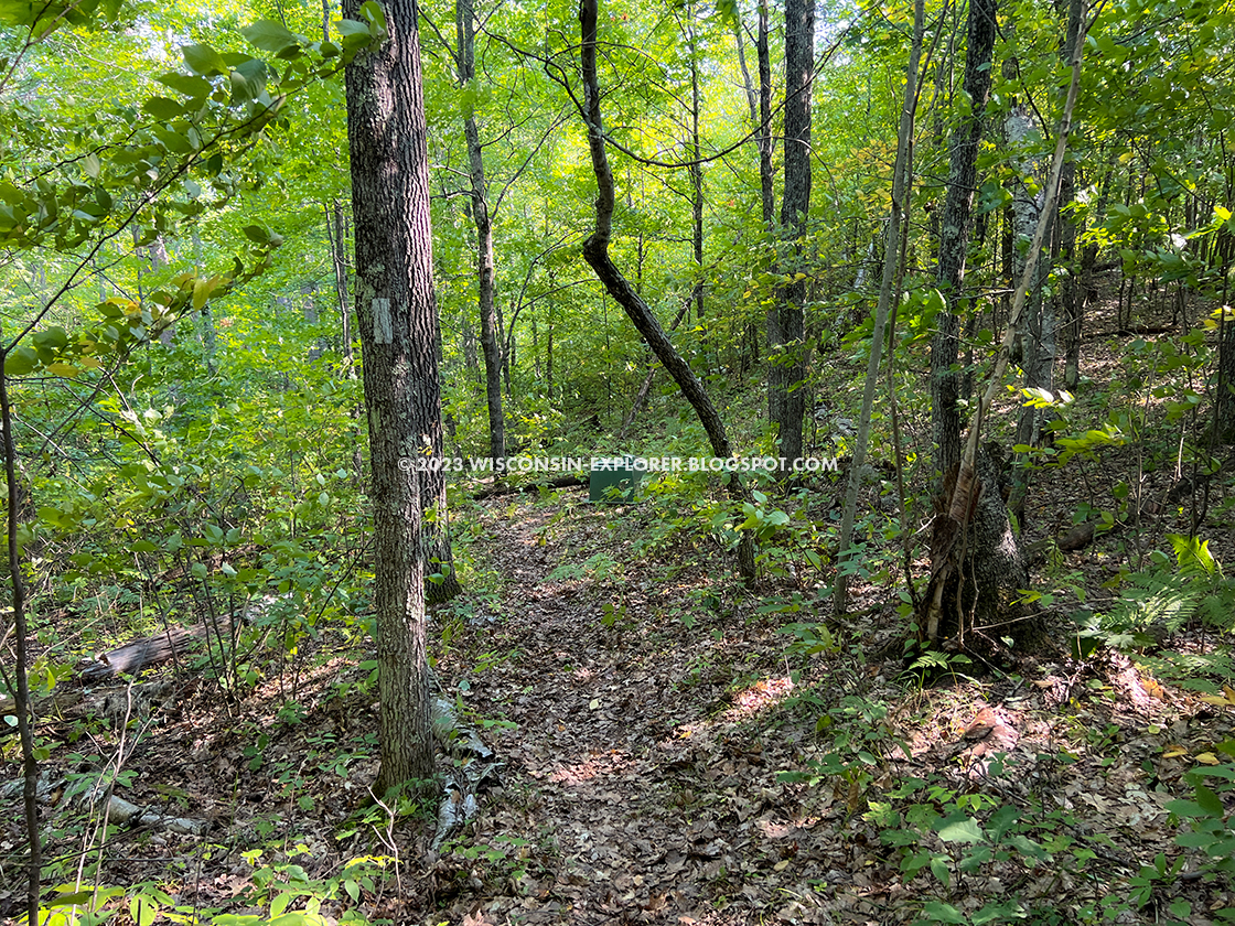
| The trail descends gradually into a some regrowth from previous logging as you approach Paul Schoh Campsite |
North Country Trail - Brule River State Forest Segment
COUNTY
DOUGLAS
COMMUNITIES
BRULE, LAKE NEBAGAMON, SOLON SPRINGS
TOTAL MILES
28-MILES POINT TO POINT
DIFFICULTY
EASY-MODERATE
LOWEST ELEVATION
1037 AMSL (HISTORIC BRULE ST CROIX PORTAGE PUT-IN)
HIGHEST ELEVATION
1268 AMSL (MORRIS POND)
TOTAL ELEVATION GAIN
4207 FT
NEXT NCT SECTION WESTBOUND
HISTORIC BRULE / ST CROIX PORTAGE TRAIL
NEXT NCT SECTION EASTBOUND
ERICK LAKE SEGMENT
CAMPING
BOIS BRULE RIVER CAMPGROUND, MORRIS POND, WINNEBOUJOU BLUFF, PAUL SCHOH, HIGHLAND, JERSETT CREEK
Directions and Trail Map
If viewing on a mobile device, open the trail map above to load into Google Maps App by touching the expand rectangle in the upper right corner.
Address for your GPS: Gaylord Nelson Portal WI-27, Lake Nebagamon, WI 54849
| coordinates: 46.45329755098374, -91.594542398298 |
| From Milwaukee | 6 Hours |
| From Madison | 5 Hours |
| From Green Bay | 5 Hours |
| From Wausau | 3.5 Hours |
| From Minneapolis | 3 Hours |
| From Chicago | 7 Hours |
Photos
ERICK LAKE TO WINNEBOUJOU BLUFF

|
| A requisite snap of a trail sign on the NCT to prove I was there. |

|
| As I approached Winneboujou Bluff I was eager for some long views of the state forest and the Brule River Valley. This is unfortunately the best view in the area, but I would soon find out that the heavy logging activity in this forest has its benefits in clearing views. |

|
| At the Winneboujou Bluff Campsite you can get some water. It's about a mile round-trip from the site to a pond and that includes a steep climb on the way back, so good to plan for some extra challenging hiking if you want to fill up here. This is a theme between Erick Lake and Jersett Creek - nowhere to refill water. |
|
| Here's a spot of nice forest on Winneboujou Bluff |

|
| The Campsite at Winneboujou Bluff is set back from the bluff and doesn't have any views, but the area around it has lots of clear flat ground. A larger group could easily setup here overnight. |

|
| The wilderness toilet at Winneboujou Bluff has some manmade privacy screening |

|
| The Winneboujou Campsite features a fire ring, bench, table, and wilderness toilet. Plenty of flat soft ground for tents and good trees for rigging hammocks. |
WINNEBOUJOU TO PAUL SCHOH

|
| Even though my many photos on this post were shot in lush forests, the reality is this forest is heavily logged out which makes for despairing hiking. |

|
| There are multiple tent pads at the Paul Schoh site. There is quite a bit of bear activity in this area. The tiny stream nearby draws alot of wildlife and saw some deer jumping around near the site. |

|
| The Paul Schoh Campsite is a first-come-first-served fee-free wilderness campsite that features a fire ring, several tent pads, a bench, picnic table, a wilderness toilet, and a questionable water source. |

|
| Here's another view of the Paul Schoh campsite. |
|
| Here's the wilderness toilet at Paul Schoh Campsite |

|
| There is a tiny trickle of water comming out of the PVC pipe in this stream at Paul Schoh Campsite. If you placed a 32oz bottle beneath the pipe it might be full in half an hour. Not the best water source, but at least its something and only a few steps outside the campsite. |
PAUL SCHOH TO HIGHLAND

|
| The marker at the Gaylord Nelson Portal parking lot is about midway on the length of the NCT Brule River SF section. |

|
| From Gaylord Nelson Portal heading westbound the trail is easy going through lots of pine plantation and logged out areas. |

|
| Here's the trail heading through some barren land that was previously logged. |

|
| Looks like some controlled burn areas, perhaps trying to regenerate oak savanna. |

|
| The forest up here resembles forest in the southern half of Wisconsin more so than the lush and dense Chequamegon nearby. |

|
| Highland Town Hall features a park with an indoor picnic shelter or lodge. Presumably this can be rented by large groups. The Highland Town Hall also features overnight parking, restrooms, and trash bins. You can see the water spigot with the red handle near the right entrance in the photo. I tried it and was unable to get water to flow, so either I don't know how to operate it or it was shut off ... It is difficult to find drinking water on this section of the trail and if you were counting on making it to Highland for a refill, I would reconsider your water plans. |

|
| Here is the restroom building at Highland Town Hall |

|
| This is the trailhead at the Highland Town Hall parking area. |

|
| Just a few hundred yards from the Highland Town Hall Park there is the Highland Campsite. This first-come-first-served campsite is primitive and fee free.; |

|
| The Highland campsite features a fire ring, picnic table, wilderness toilet, and plenty of soft flat ground for tents as well as great trees for rigging hammocks. |

|
| Standard wilderness toilet at the Highland campsite |
HIGHLAND TO JERSETT CREEK AND BRULE-ST CROIX HISTORIC PORTAGE

|
| As I approached Highland I finally left the heavily logged section of the trail behind. |

|
| I was happy to get into denser older forest as I left Highland heading towards Solon Springs |

|
| Fall colors starting to show on this September trip. |

|
| Jersett Bluff previewing some beautiful fall color. |

|
| And at a last, I made camp at the phenomenal Jersett Creek Campsite. |

|
| Jersett Creek is down a very steep hill from the campsite, I only wanted to make one trip for water to be sure. |

|
| The Jersett Creek Campsite is a first-come-first-served fee-free wilderness campsite and features a stunning site in an aspen grove on top of a conical hill above the Brule River. There are not glorious views of the Brule, but the site features a bench, fire circle, picnic table, wilderness toilet, and a reliable water source nearby. |

|
| It's always lovely to arrive at your destination to find an empty and clean campsite. |

|
| I do one annual solo backpacking overnight each Fall. This was my spot at Jersett Creek in 2022. Wilderness camping alone is an interesting experience, and I have to say that each annual overnight has been memorable and relaxing. It's my version of a spa day I guess. But, I have no intention of unplugging. I brought an ipad and did some drawing on it and watched a movie with my dinner before emptying my flask of brandy and hot apple cider. No one said that backpacking has to be roughing it. |

|
| A nice dinnertime sunset on the campsite at Jersett Creek. |

|
| Here's the trail between Jersett Creek and the historic Brule-St. Croix Section of the NCT |

|
| More easy hiking through pine plantations near Highland |