|
The Dells of Eau Claire is a Marathon county park alongside the picturesque Eau Claire River. A three mile segment of the Ice Age Trail travels through the park - and along the river through some private lands adjacent to the park.
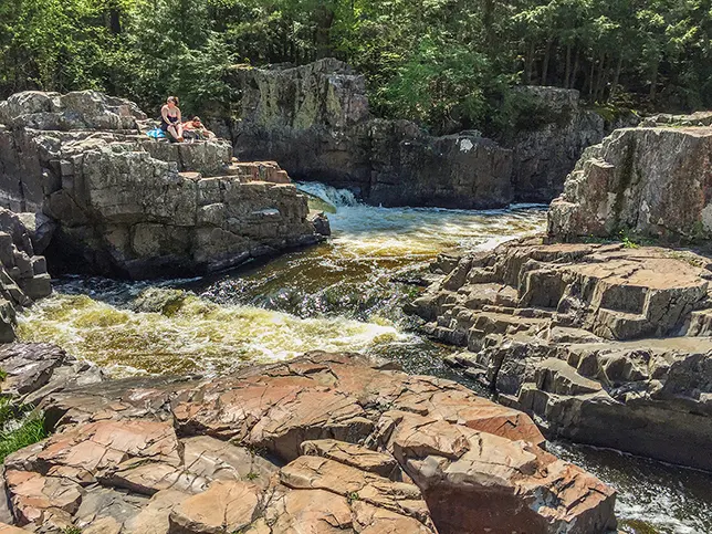
The Dells are what bring the people to this small county park. The rocky outcroppings and resulting cascade allow people to interact with and be surrounded by the river.
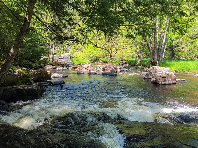
The Ice Age Trail segment that passes through here is an easy 2.6 miles linear. It courses over and alongside the Eau Claire River most of the way. Camping and other services for through hikers are available in Eau Claire Dells County Park.
advertisement

|
|
|
"...
Eau Claire, breathe of river’s life, through colossal hands- D.L.Curtiss The Dells of Eau Claire
your slender waters slip, loosed upon the quarry
wielding the wild of a vast ocean’s tide.
That which springs forth the flower swifts
into the pool where white-tail drink. With the current,
all will flow, and reach to drinking lips wherever channels row."
read the complete poem at dcurtiss00

|
|
|
It is a hard land of rock and stone and steel - Northern Wisconsin. The red ore of these iron infused rocks bakes beneath the sun - and tints the rivers of Wisconsin. Wisconsin translates to "The Red River". Glaciers of the last ice age sheered away all but this bedrock.
The factories of nature mine the stone; the roots of pine trees grind it into sand and lost waters of sculpt and carve. I say the lost waters - because truly they are. with bedrock at the surface rainwater cannot easily permeate down into aquifers, and the rivers that form on top the rocks twist and turn desperately seeking enough gravity to guide them out of a geological maze.
This phenomena is evident here at the Dells of the Eau Claire, where the river makes a roaring 90 degree turn to both the left and right. It is a violent pounding at a relentless impediment. And just a few feet to the sides of this thundering battle of time sit idle and still ponds in pacific eternity. There is something immediately sacred at the Eau Claire Dells - where a god has cast both the impatient rush of time and timelessness together in perfect contradiction. It is a spectacle of nature, a drama worthy of Shakespeare.
To leap from the cliffs into these still ponds is irresistible. And, though signs point to dangers of undercurrents - swimming here is both legal and sometimes done. The most dangerous threat is that some large piece of debris has been washed into one of the swimming holes and lurks beneath the surface. With that in mind, before you leap it would be best to do an in-the-water survey of the depths.
Most visitors to the Eau Claire Dells hike a short portion of the Ice Age Trail up to the footbridge, and from there they round the opposite bank. But, the trail continues for miles along the river - passing beneath old growth pines all the way. It is not a challenging path by elevation - though it is rocky and requires some fancy footwork.
It was pleasant all the way. I only wish that it was longer before I came to roads with signs announcing the end of this segment.

|
|
|
Overview: Ice Age National Scenic Trail - Eau Claire Dellls Segment
COUNTYMARATHON COUNTY
COMMUNITIES
ANTIGO, ANIWA
TOTAL MILES
3.6-MILE POINT-TO-POINT
DIFFICULTY
EASY
LOWEST ELEVATION
1350 AMSL
HIGHEST ELEVATION
1600 AMSL
TOTAL ELEVATION GAIN
1000 FT
TOTAL ELEVATION LOST
-880 FT
CAMPING
Dells of the Eau Claire County Park - drive in sites/self registration
POINTS OF INTEREST
Eau Claire River, Dells of the Eau Claire, 45th parallel, Beach
NEXT IAT SEGMENT EASTBOUND
THORNAPPLE CREEK SEGMENT
NEXT IAT SEGMENT WESTBOUND
PLOVER RIVER SEGMENT
Directions and Trail Map
DOWNLOAD PRINTABLE PDF USGS TOPOGRAPHIC MAPHOGERTY QUADRANGLE
Click Map Image to load the full interactive map.
Address for your GPS: P2150 County Road Y, Aniwa, WI 54408
| coordinates: N45.007327, W089.335598 |
| From Milwaukee | 3 Hours |
| From Madison | 2.5 Hours |
| From Green Bay | 1.5 Hours |
| From Wausau | 20 Minutes |
| From Minneapolis | 3.5 Hours |
| From Chicago | 4.5 Hours |
Photos

|
| Eau Claire Dells - Antigo Wisconsin |

|
| Eau Claire Dells - Antigo Wisconsin |

|
| Eau Claire Dells - Antigo Wisconsin |

|
| Eau Claire Dells - Antigo Wisconsin |

|
| Eau Claire Dells - Antigo Wisconsin |

|
| Eau Claire Dells - Antigo Wisconsin |

|
| Eau Claire Dells - Antigo Wisconsin |

|
| Eau Claire Dells - Antigo Wisconsin |
Links
The Dells of Eau Claire County Park
Ice Age National Trail - National Park Service
Ice Age Trail Alliance

