

The Northern Blue Hills Segment of the Ice Age Trail is a 9.2-mile footpath through the Rusk County Forest in Northwest Wisconsin near Rice Lake. It connects directly to the Hemlock Creek Segment at its Northwest trailhead and is separated by a short road connection to the Southern Blue Hills Segment at its Southeast trailhead.
The Northern Blue Hills is a stand-out segment for scenery. While not too hilly, this difficult segment traverses a winding, bumpy, narrow, and often muddy footpath that crosses creeks, beaver dams, and alongside other wetlands and the Murphy Flowage. Thick forest cover closes in and crackles with color in autumn.
Parking lots are provided at the Northwest trailhead on Bucks Lake Road, and a large lot is near the midpoint of the segment at the end of Stout Road. There is (technically legal) limited and precarious shoulder parking available on Highway F about a quarter mile west of the southeast trailhead.
Dispersed camping is allowed anywhere between Bucks Lake Road and Devils’ Creek along this segment. However, there are no established primitive camps. A few drive-in campsites are located nearby at Murphy Flowage Recreation Area, which is also the nearest location for restrooms, potable water, and shelter.
{tocify} $title={Table of Contents}
$ads={1}

I saved some of the best for last. When I was requesting time off in early 2023, I knew I’d be finishing my remaining hikes of segments of the Ice Age Trail that Fall. I had scheduled a 4-day weekend in late September to catch peak fall colors while I completed the IAT segments in Rusk County. Indeed, I correctly predicted peak fall color. Unfortunately, I had not predicted four consecutive days of downpouring rain.
Camped at Murphy Flowage, my tent lasted halfway through the first night and a relentless storm before springing leaks. To salvage what was left of my vacation I moved to one of my favorite AirBnB’s in an apple orchard near the IAT trailheads. From that warm, dry, and comfortable staging point, I made multiple trips to the IAT to complete Blue Hills Segments in a series of out-and-backs.
I relied on the parking lot at the end of Stout Road. One morning, I started from Stout Road, hiked about 5 miles north to Bucks Lake Road, and then returned. Later that afternoon, I hiked south from Stout Lake Road to Devil’s Creek and back. This grueling day of hiking added up to 20-plus miles.
In spite of the wet, cold, and gray weather, the incredible scenery of this trail encouraged me on. The trail cut along beaver dams past ponds with enormous beaver lodges that must have been generations in the making. It also traced the banks of a fork of Hemlock Creek while making multiple crossings. Devil’s Creek is even more scenic than the branch of Hemlock Creek.
The trail itself varies between the barely visible single-track footpath and two-track road. The troads made hiking easy, but also fell into mud pits and overflowing puddles in the ruts.
While hiking and contemplating the end of my journey on the Ice Age Trail, I realized that I had somehow overlooked or forgotten to hike the Sand Creek Segment. I had to return the following weekend to complete that segment. So, I intentionally left the 1-mile-long length of the Northern Blue Hills Segment between lots on South Bucks Road to catch on my way home after completing Sand Creek. This plan allowed me to complete my multi-year goal of hiking every segment of the Ice Age National Trail on that last mile of the Northern Blue Hills Segment.
Why I revered this segment I cannot say for sure. It was an elusive challenge. A formidable length that was not easy or convenient for me to access from my home in southern Wisconsin. The Blue Hills Segments loomed over me and always seemed too much to take on. At some point, I decided that I wanted my quest to hike the IAT to end on a legendary segment worthy of the long journey – and I selected this segment to provide that sense of closure.
It was a beautiful, warm, and sun-drenched autumn afternoon. Unceremoniously, I completed my last mile of the IAT, walked along South Bucks Lake Road to return to my car, rolled down the window, and sped off down County Highway F.
This completes my journey on the Ice Age Trail and the purpose of starting and writing this blog—a weblog about my hikes in Wisconsin.
But a new journey awaits.
In the ten years it took me to complete all the segments of the Ice Age Trail, I have been transformed. I have met many friends along these miles, and I have camped and vacationed in every corner of the state this trail brings us to. Over these years and with these new friends, I have discovered that my sense of adventure and wilderness camping is not satisfied by hiking in the shade of the forest.
My first wilderness backpacking trip was along the IAT Lake Eleven Segment. Since that introduction to backpacking, I have learned to be self-reliant and love the solitude of wilderness camping. My next chapters will be explorations by canoe of Wisconsin’s wild and scenic rivers and lakes. I will paddle to the islands of Lake Superior and downriver through the mighty national forests of Minnesota, Wisconsin, the Upper Peninsula … and perhaps even Ontario. The adventure that started with an afternoon stroll on the IAT in Cross Plains continues in search of bigger woods and deeper wilderness.

Ice Age National Scenic Trail Northern Blue Hills Segment
COUNTY
RUSK
COMMUNITIES
WILKENSON, WEYERHAEUSER
TOTAL MILES
9.6-MILES POINT-TO-POINT
DIFFICULTY
MODERATE
LOWEST ELEVATION
1290 AMSL
HIGHEST ELEVATION
1700 AMSL
CUMMULATIVE TOTAL ELEVATION GAIN
1650 FT
NEXT IAT SEGMENT EASTBOUND
IAT SOUTHERN BLUE HILLS SEGMENT
NEXT IAT SEGMENT WESTBOUND
IAT HEMLOCK CREEK SEGMENT
Directions and Trail Map
If viewing on a mobile device, open the trail map above to load into Google Maps App by touching the expand rectangle in the upper right corner.
Nearest address for your GPS: N6304 Stout Rd, Weyerhaeuser, WI 54895
| coordinates: 45.53925562883855, -91.46025444715012 |
| From Milwaukee | 5 Hours |
| From Madison | 4 Hours |
| From Green Bay | 4 Hours |
| From Wausau | 2.5 Hours |
| From Minneapolis | 2.5 Hours |
| From Chicago | Hours |
Photos

|
| There is a huge parking lot at the end of Stout Road. I staged two out-andm-backs from this lot in opposite directions to complete this segment. |


|
| A precarious trail over a very old beaver dam |


|
| There is parking on the shoulder at South Bucks Lake Road as well |


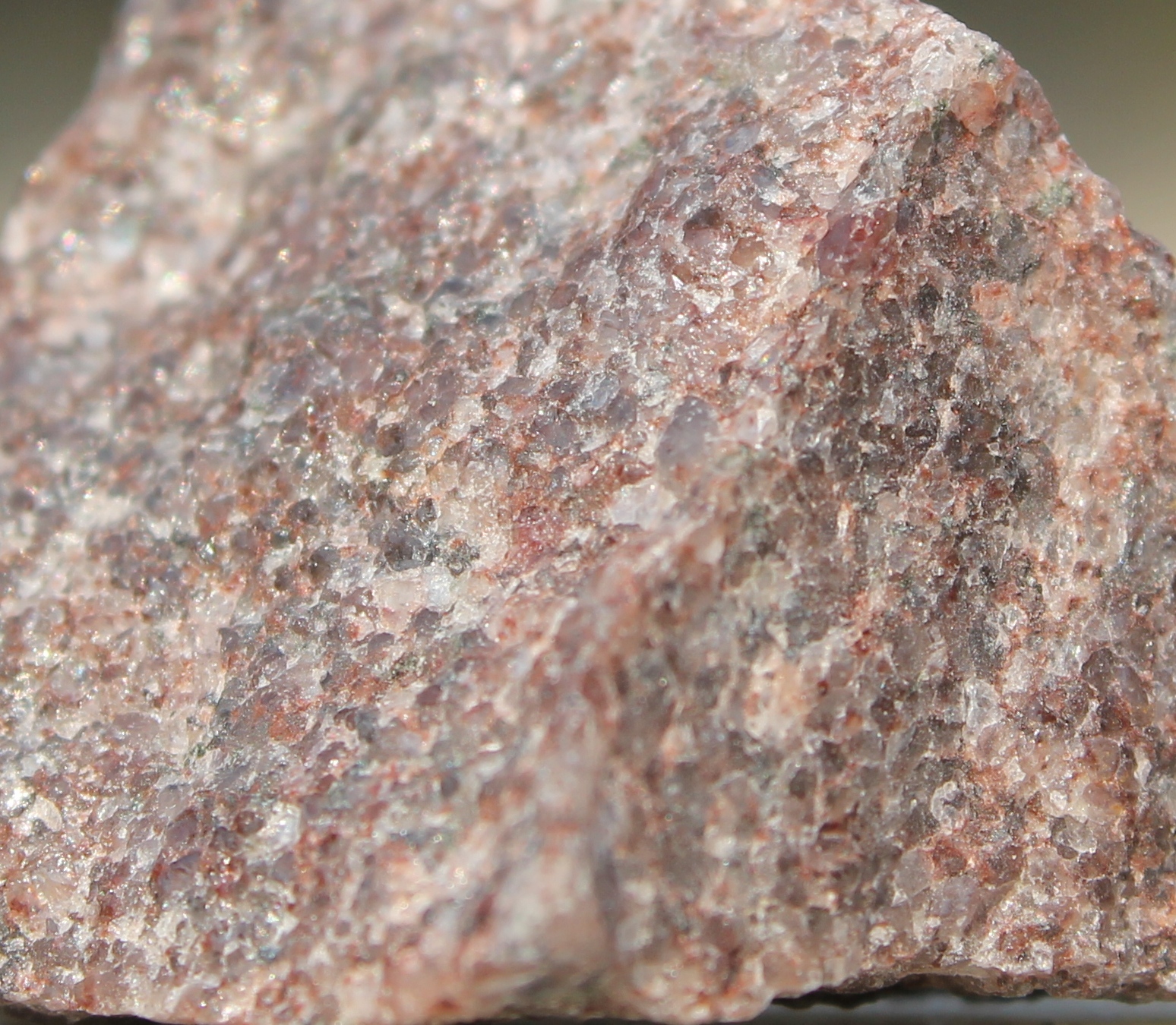
Quartzite
Metamorphic rock
A hard metamorphic rock formed from quartz-rich sandstone, characterized by interlocking quartz crystals and a glassy to granular texture.

Zircon
ZrSiO₄
A zirconium silicate mineral that forms small reddish-brown prismatic crystals and appears as heavy accessory grains in the Blue Hills quartzite.

Lake Superior agate
Banded chalcedony
A colorful variety of banded chalcedony formed in volcanic gas cavities, displaying concentric red and orange bands around a quartz core and found as glacially transported agates in northwestern Wisconsin.

Golden-winged warbler
Vermivora chrysoptera
A slender gray warbler with yellow crown and wing patches and a black facial mask that breeds in shrubby young forests but is now increasingly rare.

Scarlet tanager/p>
Piranga olivacea
Brilliant red songbird with black wings that breeds in deciduous forests and migrates to South America for the winter.

Pileated woodpecker
Dryocopus pileatus
Large black woodpecker with a blazing red crest and bold white stripes along the face that excavates big rectangular holes and resides year‑round in Wisconsin forests.