

|
| Brownstone Falls on the North Country Trail Copper Falls Section |
Wisconsin hosts 200-miles of the North Country National Tail, America's longest national trail. This hiking trail passes through Iron, Ashland, Bayfield, and Douglas Counties in Northern Wisconsin. Some of the trail is still undeveloped, but large sections of the Wisconsin portion are complete, and backpackers can hike for several days on the NCT while camping at primitive sites along the trail.
The Wisconsin Segments of the NCT routes hikers to stunning waterfalls, alongside dozens of lakes, over countless streams and rivers, on mile-long boardwalks through bogs, and deep into remote northern forests. Black bear, elk, eagles, wolves, and cougars call this trail home. Backpackers in the Chequamegon and Brule River sections of the NCT can immerse themselves completely in wilderness while hiking for up to 3 days without crossing a paved road. Day and section hikers can also string together out-n-back day hikes and a few loop routes connected to the mainline.
{tocify} $title={Table of Contents}
$ads={1}
advertisement
Trail Map

Click Map Image to load the full interactive map.
The map above is updated as of December 2024
North Country Trail Sections in Wisconsin and Articles
Hertiage Chapter Section
The NCT section between the Michigan State Line and the Chequamegon National Forest west of Mellen is maintained and managed by the Heritage Chapter of the North Country Trail Association - a nonprofit volunteeer group. The Heritage Chapter section features Lake Superior shoreline and passes through the expansive Iron County Forest along scenic rivers past waterfalls and through Copper Falls State Park.
Michigan State Line to Gurney WI (UNDEVELOPED)
COUNTYIRON COUNTY
COMMUNITIES
SAXON HARBOR, CEDAR, GURNEY
TOTAL MILES
Undeveloped
DIFFICULTY
Easy - on roads
CAMPING
Saxon Harbor Campground, Potato River Falls Campground
POINTS OF INTEREST
Lake Superior, Iron County Forest, Potato River, Potato River Falls

(NCT) Gurney to Foster Falls Segment
COUNTYIRON COUNTY
COMMUNITIES
Gurney
TOTAL MILES
UNDEVELOPED
DIFFICULTY
MODERATE
CAMPING
Dispersed Camping along full route in Iron County Forest, Hemlock Glen Primitive Campsites (2),
POINTS OF INTEREST
Potato River, Foster Falls - 3 pitches (upper, middle, and lower falls), Loggers Cabin
Opening in 2025, this segment immerses hikers in the lush Iron County Forest along the rock-strewn Potato River. Three waterfalls along the trail delight hikers. There are more potential dispersed campsites than can be counted on both banks of the Potato River. Two excellent primitive first-come-first-serve campsites have been established.

(NCT) Foster Falls to Wren Falls Segment
COUNTYIRON COUNTY
COMMUNITIES
SAXON
TOTAL MILES
8.4-MILES POINT-TO-POINT
DIFFICULTY
MODERATE
CAMPING
Dispersed Camping along full route in Iron County Forest, Wren Falls Primitive Site, Goldmine primitive Site, Tilted Gabro primitive site, Foster Falls drive-in primitive site
POINTS OF INTEREST
Wren Falls, Tyler Forks of Bad River, Iron County Forest, Casey Overlook, Goldmine, Upson Overlook, Upson Lake, Potato River, Foster Falls
A newer section of trail, completed in 2020, connects two scenic waterfalls. There are five primitive campsites along this section, four of which are located at positions alongside Iron County's famously scenic rivers. This section is a perfect one-night backpacking route. It is shorter, but packs in scenery and hill climbs. This trail section will give you a taste of Wisconsin backcountry hiking at its best.
ARTICLE (WISCONSIN-EXPLORER)

(NCT) Porcupine Hill Segment
COUNTYIRON COUNTY, ASHLAND COUNTY
COMMUNITIES
MELLEN
TOTAL MILES
5.7-MILES POINT-TO-POINT
DIFFICULTY
DIFFICULT
CAMPING
Dispersed Camping along full route in Iron County Forest, Wren Falls Primitive Site, Porcupine Hill Prmitive Site
POINTS OF INTEREST
Porcupine Hill, Wren Falls, Tyler Forks River, Iron County Forest
This relatively short segment carries hikers through the Iron County Forest between Wren Falls and Copper Falls State Park. Porcupine Hill is the central feature of this segment. It is not particularly high in elevation and doesn't have any outstanding overlooks, but the trail generally meanders up, over, and down the hill on both approaches.
This segment is bookended by crossings of Tyler Forks - a scenic tannin dyed river. This segment is easy to access with large parking lots at each end. It also includes two primitive campsites for overnight backpackers - both near reliable drinking water sources (always filter your drinking water).
ARTICLE (WISCONSIN-EXPLORER)

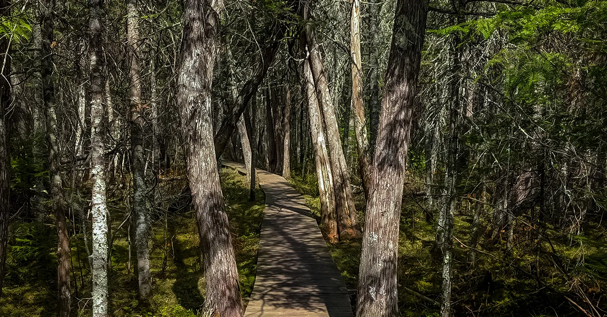
(NCT) Copper Falls Segment
COUNTYASHLAND COUNTY
COMMUNITIES
MELLEN
TOTAL MILES
10.5-MILES POINT-TO-POINT
DIFFICULTY
MODERATE
CAMPING
Copper Falls State Park, Copper Falls State Park Remote Site, Dispersed Camping Area
POINTS OF INTEREST
Bad River, Tyler Forks of the Bad River, Brownstone Falls, Copper Falls, Copper Falls State Park, Loon Lake, Mellen
This section of the NCT begins at the Highway 169 Trailhead and meanders through Copper Falls State Park alongside the Bad River.
Most visitors to Copper Falls State Park will hike a small portion of the NCT that parallels The Doughboy's Trail. This scenic park trail loops around the confluence of Tyler Forks of the Bad River and The Bad River. Two of the Midwest's most magnificent waterfalls are viewed from this trail.
ARTICLE (WISCONSIN-EXPLORER)
(NCT) Copper Falls to Penokee Trailhead Segment
COUNTYASHLAND COUNTY
COMMUNITIES
MELLEN
TOTAL MILES
4-MILES POINT-TO-POINT
DIFFICULTY
EASY
The NCT continues on off-the-road trails from Copper Falls State Park towards Mellen, with the trail following within view of Highway 169. At Mellen, the route of the trail follows sidewalks and roads for three miles before turning off into the Chequamegon National Forest. After a brief walk through the woods the trail reaches the Penokee Ski Trail Trailhead at Highway GG.
Chequamegon Chapter Section
The NCT section between the Penokee Mountain and Ruth Lake is maintained and managed by the Chequamegon Chapter of the North Country Trail Association - a nonprofit volunteeer group. NCT segments in the Chequamegon National Forest feature deep woods hiking to panoramic overlooks, wilderness northwoods lakes, scenic rivers and streams, historic sites, old growth forest, and two non-motorized federal wilderness areas. This is the heart of the North Country Trail in Wisconsin.

(NCT) Chequamegon: Penokee Mountain Ski Trail Segment
COUNTYASHLAND COUNTY
COMMUNITIES
MELLEN, FOSTER JUNCTION, MORSE
TOTAL MILES
3.1-MILES POINT-TO-POINT
DIFFICULTY
MODERATE
CAMPING
Primitive Camping anywhere along this route in the Chequamegon National Forest. Penokee Adirondack Shelter
POINTS OF INTEREST
Penokee Overlook
These first miles of the NCT in the Chequamegon may seem unremarkable as they follow wide, often swampy, and unscenic ski trails. A single track trail cuts from a small parking lot on Kornstead Road over to the larger Penokee Mountain Trailhead lot where there is a vault toilet and parking area. There is a short side trail up wood steps to the Penokee Overlook from the Penokee Trailhead Lot. That will be your only shot at scenery along this section. Otherwise, the trail follows ski trails upwards towards the Penokee Warming Shelter which can be used for camping in spring, summer, and fall.
ARTICLE (WISCONSIN-EXPLORER)

(NCT) Chequamegon: Hanson Field Segment
COUNTYASHLAND COUNTY
COMMUNITIES
MORSE
TOTAL MILES
4.2-MILES POINT-TO-POINT
DIFFICULTY
DIFFICULT
CAMPING
Primitive Camping anywhere along this route in the Chequamegon National Forest
POINTS OF INTEREST
Hanson Field, Overlook
The Penokee Warming Shelter is near the begining of the Hanson Field Section. Between this shelter and the Beaver Lake Campground there are few established campsites and you will be hard pressed to find a good place to setup for an overnight. From Penokee Shelter the trail gradually descends to a heavy flowing branch of Trout Creek where there is a new bridge. This is a great place for a water refill and a scenic landing for photos.
The trail then climbs into the Penokee Range where random projections of rock emerge from the forest floor. An overlook above the trees greets hikers at the top of the next high point. The trail then descends to cross Hanson Road. Another set of hills awaits across the road before the trail levels out as it passes through Hanson Field, a grassy stretch that is a former homestead. It would be comfortable to setup a campsite at Hanson Field, but a primitive site hasn't been established yet.
ARTICLE (WISCONSIN-EXPLORER)

(NCT) Chequamegon: Brunsweiler River Segment
COUNTYASHLAND COUNTY, BAYFIELD COUNTY
COMMUNITIES
MORSE, MARENGO
TOTAL MILES
3.8-MILES POINT-TO-POINT
DIFFICULTY
DIFFICULT
CAMPING
Primitive Camping in most areas along this route in the Chequamegon National Forest
POINTS OF INTEREST
Brunsweiler River, Lake Three
The Brunsweiler River Section crosses through a pine plantation across a second cossing of Hanson Road. The trail crosses Hanson Road a third time before climing to heights above Beaverdam Lake. It then descends gradually to an old railroad grade and finally to a bridge crossing the scenic Brunsweiler River. This river is beleived to be the place where Chief Namekagon collected pure silver rocks which made him locally famous.
There are remnants of a fire circle and apparantly a primitive campsite on the west bank of the river near the bridge, but the area is strewn with rocks and in the shadow of steep escarpment which could shed water and quickly flood this site out in a strong rainstorm. Be careful not to camp on the north side of the trail which is private property along the river.
From the Brunsweiler Bridge the NCT climbs steeply and rides a ridge down towards Lake Three. Lake Three used to have an excellent campground and recreation area, but it has been closed by the Forest Service. There remains a vault toilet in the abandoned campground, and a lake access ramp. The water pump has been locked. You'll have to dip into the lake for a water refill.
ARTICLE (WISCONSIN-EXPLORER)

(NCT) Chequamegon: Marengo River Valley Segment
COUNTYBAYFIELD COUNTY
COMMUNITIES
MARENGO, MASON
TOTAL MILES
9.8-MILES POINT-TO-POINT
DIFFICULTY
DIFFICULT
CAMPING
Primitive Camping in most areas along this route in the Chequamegon National Forest, Beaver Lake Campground, Marengo Adirondack Shelter
POINTS OF INTEREST
Beaver Lake, Swedish Settlement, Marengo River, Juniper Overlook, Marengo Overlook
From Mineral Lake Road the trail is wide and easy, climbs a few bumps and crosses streams on bridges. These fast flowing streams are great for water refills. After two quick miles you will reach a spur for Beaver Lake where there is shoulder parking near the trailhead, a small popular campground that is usually filled to capacity, water pumps, and two vault toilets. Otherwise, the trail continues to wind along the north end of Beaver Lake and begins to climb long hills. Be prepared to climb again after reaching the bottom of valleys.
Hikers will cross two seperate branches of Whiskey Creek, a branch of the Marengo River, and the Marengo River proper on this trail. The trail reaches impressive heights above the Marengo River Valley where there are a series of grand overlooks. Near the overlook is a network of side trails leading to the ruins of a former Swedish Seettlement.
If you bypass the Swedish Settlement you will descend a massive hill though pine plantations to the steep banks of the Marengo River where you will find the Marengo Shelter tucked into the pines. The trail then regains heights at the Juniper overlook, a bald outcropping with long views of the Marengo Valley and Chequamegon Forest. From there its only a mile to reach the very spacious Swedish Settlement Parking Area which is one of the best places to park a vehicle for accessing these deep woods sections of the NCT.
ARTICLE (WISCONSIN-EXPLORER)

(NCT) Chequamegon: Long Mile Lookout Segment
COUNTYBAYFIELD COUNTY
COMMUNITIES
MASON, GRANDVIEW
TOTAL MILES
9.8-MILES POINT-TO-POINT
DIFFICULTY
DIFFICULT
CAMPING
Primitive Camping in most areas along this route in the Chequamegon National Forest, East Davis Lake Primitive Site
POINTS OF INTEREST
Twentymile Creek, Longmile Lookout, East Davis Lake
Heading west from Swedish Settlement hikers will endure another course of hill climbs eventually culminating at Longmile Lookout Tower. The trail crosses the fast flowing Twentymile Creek beside Forest Road 378/ Wisco Road which has cold water for filtering - a special treat on a hot day.
Longmile Lookout will leave you wanting for long views, but instead, hikers will simply return to the shade of hardwood forest and descend a long gradual hill to reach East Davis Lake where there is a nice campsite with room for four tents on graded pads. It may be hard to spot them tucked in beneath the pines, but they are only a few steps off the trail next to the lake.
ARTICLE (WISCONSIN-EXPLORER)

(NCT) Chequamegon: Porcupine Lake Wilderness Segment
COUNTYBAYFIELD COUNTY
COMMUNITIES
DRUMMOND
TOTAL MILES
4.3-MILES POINT-TO-POINT
DIFFICULTY
DIFFICULT
CAMPING
Primitive Camping in most areas along this route in the Chequamegon National Forest, Primitive sites at Porcupine Lake
POINTS OF INTEREST
Porcupine Lake, Porcupine Lake Wildernes
The Porcupine Lake Wilderness is thick with vegetation, and in summer it feels jungle-like, with fern covered forest floors and dark shade on blue sky days. There are at least two established campistes at Porcupine Lake. The night life beside Porcupine Lake is very active and filled with Owl and loon calls from dusk to dawn. Listen for wolf howls from the Porcupine Lake Wolf Pack.
Hikers cross Porcupine Creek and Eighteenmile Creek on primitive 'bridges'. Both streams are heavy flowing and great sources for drinking water. A 1-mile long spur trail cuts off towards Two Lakes Recreation Area and Campground.
ARTICLE (WISCONSIN-EXPLORER)

(NCT) Chequamegon: Lake Owen Segment
COUNTYBAYFIELD COUNTY
COMMUNITIES
DRUMMOND
TOTAL MILES
5-MILES POINT-TO-POINT
DIFFICULTY
MODERATE
CAMPING
Two Lakes Campground, Primitive Camping in some areas along the trail in the Chequamegon National Forest. Be careful to avoid private land along this route.
Between the Porcupine Lake Wilderness and the Lake Owen Picnic Grounds a gentle trail passes through dark hemlock groves where prehistoric American Indian settlements once stood on the shore of Lake Owen. This is a popular day hike between the Picnic Grounds and the absolutely gorgeous and whisper quiet Two Lakes Campground.
ARTICLE (WISCONSIN-EXPLORER)

(NCT) Chequamegon: Drummond Ski Trails Segment
COUNTYBAYFIELD COUNTY
COMMUNITIES
DRUMMOND
TOTAL MILES
5.5-MILES POINT-TO-POINT
DIFFICULTY
MODERATE
CAMPING
Primitive Camping along the trail in the Chequamegon National Forest. In the winter skiing season camping in the ski area should be avoided.
The NCT trail widens onto grass tread as it shares the XC ski trail routes in the Drummond Ski Trail Area. Navigation of this maze of ski trails is easy with a map and day hikers can make a loop hike in the ski trail area.
ARTICLE (WISCONSIN-EXPLORER)

(NCT) Chequamegon: Drummond Area Section
COUNTYBAYFIELD COUNTY
COMMUNITIES
DRUMMOND
TOTAL MILES
6.1-MILES POINT-TO-POINT
DIFFICULTY
DIFFICULT
CAMPING
Primitive Camping in most areas along this route in the Chequamegon National Forest, Primitive sites at Long Lake Branch Creek and Mirror Lake
POINTS OF INTEREST
Drummond Woods State Natural Area, Long Lake Branch Creek, Esox Lake, Mirror Lake, Overby Lake
The Drummond area trail crosses through one of the last three remaining virgin forests in Wisconsin. White pine, three feet in diameter, tower overhead. The trail then negotiates a network of interconnected lakes where you will find a number of established primitive campsites.
ARTICLE (WISCONSIN-EXPLORER)

(NCT) Chequamegon: Rainbow Lake Wilderness Segment
COUNTYBAYFIELD COUNTY
COMMUNITIES
DRUMMOND, DELTA
TOTAL MILES
6.1-MILES POINT-TO-POINT
DIFFICULTY
EASY
CAMPING
Primitive Camping in all areas along this route in the Chequamegon National Forest, Primitive sites at Reynard Lake, Rainbow Lake, Anderson Lake, and Tower Lake
POINTS OF INTEREST
Rainbow Lake Federal Wilderness, Nelson Lake, Stratton Ponds, Reynard Lake, Wishbone Lake, Bufo Lake, Anderson Grade Trail, Rainbow Lake, Tower Lake,
Leaving the roads behind, hikers enter one of the most remote areas in Wisconsin, the Rainbow Lake Wilderness. Listen for bugling elk and keep an eye out for black bear and wolves as you weave between lakes. On the banks of Rainbow Lake you will find two primitive campsites.
Anderson Lake, and Tower Lake also host campsites. The best one is said to be at Anderson Lake, but you will have to hike 1-mile west along the Anderson Grade to reach it. Going east along the Anderson Grade for 2-miles will take you to the Perch Lake Campground and Recreation Area. North of Tower Lake is a 1.5-mile trail to a parking lot.
ARTICLE (WISCONSIN-EXPLORER)

(NCT) Chequamegon: Ruth Lake Segment Segment
COUNTYBAYFIELD COUNTY
COMMUNITIES
DELTA, BRULE, IRON RIVER
TOTAL MILES
7.5-MILES POINT-TO-POINT
DIFFICULTY
EASY
CAMPING
Primitive Camping along the trail in the Chequamegon National Forest and Bayfield County Forest
Hikers leave the Chequamegon behind and enter the Bayfield County Forest. The Ruth Lake Segment is an easy to access segment with parking areas at each end. The trail is straight, flat, and wide.
ARTICLE (WISCONSIN-EXPLORER)
Brule-St Croix Chapter Section
The NCT section between the Chequamegon National Forest and the Minnesota State Line is maintained and managed by the Brule-St Croix Chapter of the North Country Trail Association - a nonprofit volunteeer group. The Brule-St Croix Section features sun drenched walks from hilltop to hilltop in the Brule County Forest, then descends along one of the most historic routes in the United States towards Solon Springs. From the quaint trailtown of Solon Springs the trail passes through Douglas County Wildlife areas and forest to meet the St. Croix National Scenic River before cutting north past towering waterfalls and eventually joining the famed Superior Trail in Minnesota.

(NCT) Erick Lake Segment
COUNTYBAYFIELD COUNTY
COMMUNITIES
BRULE, WINNEBOUJOU
TOTAL MILES
11-MILES POINT-TO-POINT
DIFFICULTY
MODERATE
CAMPING
Primitive Camping along the trail in the Bayfield County Forest, Primitive Campsites at Erick Lake, Morse Pond, and Winneboujou
Heading west from a trailhead at Bayfield County A you'll grow fond for the wilderness and national forest land you left behind. Heavily logged out forest has resulted in low visibility thicket tunnels of young aspen and oak and sun-exposed clear-cut scraplands.
But a pair of beautiful campsites at Erick Lake and Morris Pond welcome tired and thirsty hikers 4-5 miles in. The NCT continues its westward trek another 7-miles through plantations before reaching the Winneboujou Trailhead and parking lot on Samples Road.
ARTICLE (WISCONSIN-EXPLORER)

(NCT) Brule River State Forest Segment
COUNTYBAYFIELD COUNTY, DOUGLAS COUNTY
COMMUNITIES
BRULE, WINNEBOUJOU, HIGHLAND, SAUNTRY
TOTAL MILES
15-MILES POINT-TO-POINT
DIFFICULTY
MODERATE
CAMPING
Primitive Campsites at Winneboujou Bluff, Paul Schoh, Highland, and Jersett Bluff
Through the thick and wild Brule River State Forest the NCT parrells the Brule River at a distance and ontop the valley bluff. There are four primitive campsites that break up this section. Drinking water sources are few and far between, but there is a good stream at Jersett Creek near the Jersett Bluff Campsite.
ARTICLE (WISCONSIN-EXPLORER)

(NCT) Historic Brule-St Croix Portage Trail Segment
COUNTYDOUGLAS COUNTY
COMMUNITIES
SOLON SPRINGS
TOTAL MILES
1.9-MILES POINT-TO-POINT
DIFFICULTY
MODERATE
POINTS OF INTEREST
Bois Brule River, Headwaters of the Bois Brule River, Headwaters of the St. Croix River, Historic Portage Trail
The most historic hiking trail in Wisconsin is the Brule-St. Croix Portage Trail established as a fur trading route in 1680 by the French and used as a portage route by American Indians for thousands of years before that. Today it remains a footpath connecting two of the most scenic rivers in America.
ARTICLE (WISCONSIN-EXPLORER)
(NCT) Brule Bog Segment
COUNTYDOUGLAS COUNTY
COMMUNITIES
SOLON SPRINGS
TOTAL MILES
2-MILES POINT-TO-POINT
DIFFICULTY
EASY
CAMPING
Primitive site at Catlin Creek
POINTS OF INTEREST
Brule Bog, St. Croix River, Catlin Creek
A 2-mile long boardwalk crosses a dense cedar bog on the north end of Lake St. Croix. This trail is an easy walk for family excursions.
ARTICLE (WISCONSIN-EXPLORER)
(NCT) Solon Springs Segment
COUNTYDOUGLAS COUNTY
COMMUNITIES
SOLON SPRINGS
TOTAL MILES
7.5-MILES POINT-TO-POINT
DIFFICULTY
EASY
CAMPING
Aden Creek Campsite, Lucius Woods Campground
The Solon Springs Section follows along roads and through a couple of parks in Solon Springs before crossing Highway 53. Camping is available at Aden Creek Primitive Site and at Lucius Woods Park.
(NCT) The Bird Sanctuary Segment
COUNTYDOUGLAS COUNTY
COMMUNITIES
SOLON SPRINGS
TOTAL MILES
6-MILES POINT-TO-POINT
DIFFICULTY
EASY
CAMPING
Primitve Campsites at Leo Creek, Rovers Lake,
From Highway 53, the trail heads south through a series of wildlife and natural areas before entering the Douglas County Forest. There are primitive sites at Leo Creek and Rovers Lake.

(NCT) Rovers Lake to Gordon Dam Segment
COUNTYDOUGLAS COUNTY
COMMUNITIES
SOLON SPRINGS, GORDON
TOTAL MILES
5.25-MILES POINT-TO-POINT
DIFFICULTY
EASY
CAMPING
Primitive site at Rovers Lake, Gordon Dam Flowage County Campground
POINTS OF INTEREST
Rovers Lake, Douglas County Wildlife Area, Douglas County Forest, St Croix Flowage
From restored prarie to meandering boardwalks through wetlands, wildlife is prolific on this short segment approaching the St Croix River.
ARTICLE (WISCONSIN-EXPLORER)

(NCT) St. Croix River Segment (Gordon Dam to Mail Road)
COUNTYDOUGLAS COUNTY
COMMUNITIES
GORDON
TOTAL MILES
2.5-MILES POINT-TO-POINT
DIFFICULTY
EASY
CAMPING
Gordon Dam County Park Campground, Primitive site at Scotts Rapids
POINTS OF INTEREST
St. Croix National Scenic River, Gibson Cabin, Gordon Dam County Park
One of Americas's first Wild and Scenic Rivers the St. Croix River begins at Gordon Dam where you can also begin a route of the North Country Trail. This portion of trail features a few views of the St. Croix, a historic log cabin to explore, and a rustic campsite beside Scotts Rapids.
ARTICLE (WISCONSIN-EXPLORER)

(NCT) Pattison State Park Segment
COUNTYDOUGLAS COUNTY
COMMUNITIES
SUPERIOR
TOTAL MILES
1.5-MILES POINT-TO-POINT
DIFFICULTY
EASY
CAMPING
Pattison State Park Campground
POINTS OF INTEREST
Black River, Big Manitou Falls, Little Manitou Falls, Pattison State Park
The North Country Trail spans between two magnificent waterfalls in Pattison State Park. The length of the trail follows the scenic Black River. The park offers amenities and campsites.
ARTICLE (WISCONSIN-EXPLORER)
(NCT) Macquarrie Ponds Segment
COUNTYDOUGLAS COUNTY
COMMUNITIES
SUPERIOR, DEWEY
TOTAL MILES
4-MILES POINT-TO-POINT
DIFFICULTY
MODERATE
CAMPING
Primitve Campsite
A scenic corner of the state, the area between the Namadji River and along Clear Creek hosts a winding section of the NCT along with a new primitive campsite before crossing the border to Minnesota.
You have done a wonderful presentation in this blog. Is an excellent resource for the subject matter presented. Thanks for sharing.
ReplyDelete